
-
 4556 Hits
-
 84.82% Score
-
 19 Votes
|
|
Mountain/Rock |
|---|---|
|
|
46.77902°N / 12.23675°E |
|
|
Hiking, Skiing |
|
|
Summer, Fall, Winter |
|
|
7096 ft / 2163 m |
|
|
Overview
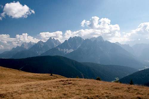
 The Roßzogel summit plateau with the Villgraten and Rieserferner Groups behind The Roßzogel summit plateau with the Villgraten and Rieserferner Groups behind |
Roßzogel, sometimes also Roßkogel or in Italian Monte Cavallo is the westernmost mountain of the Riepenspitze Group, a subgroup of the Villgraten Group in the southern Hohe Tauern. It is located above Pustertal / Val Pusteria and is the cornerstone mountain, where Gsieser Tal / Valle di Casies joins the broader Valley. Actually a lower ridge of tree covered mountains separates Roßzogel / Monte Cavallo from Pustertal / Val Pusteria but it is of little geographic importance (though historically it is interesting since an old Roman highway traverses its ridge).
Roßzogel / Monte Cavallo is a long stretched mountain with a barely pronounced summit, which is set back from both aforementioned valleys. At 2163m it barely passes the timberline and the summit area looks like a wide meadow, which in fact it is, at least in the summer months when you can find herds of cattle grazing up there. From the summit a ridge turns eastward, connecting it with Golfen / Monte Calvo and Hochhorn / Corno Alto. There the ridge connects with the Riepenspitze Group main ridge, which runs north to south but bends eastward in this point.
 |  |  |
Roßzogel / Monte Cavallo is part of Toblacher Höhenweg, a two day hiking / trekking trail, which traverses the complete south of the southern Riepenspitze Group. The ridge traverse ascends twelve summits and is wonderfully panoramic. The sole place of accommodation is Pfannhornhütte / Rifugio Corno Fana to the south of Toblacher Pfannhorn. The first five summits can be climbed during a long day tour, for which you have to account some 1800m elevation difference.
Roßzogel / Monte Cavallo itsef is the lowest of teh summits on Toblacher Höhenweg and thus offers only modest views. Still thanks to the fact that the Sexten / Sesto Dolomites tower south of Pustertal / Val Pusteria and the Rieserferner Group is located across Gsieser Tal / Valle di Casies the mountain is also an interesting destination in itself. In winter it is often climbed as a ski or snowshoe destination, though most of the times only as a stage during the Hochhorn / Corno Alto climb.
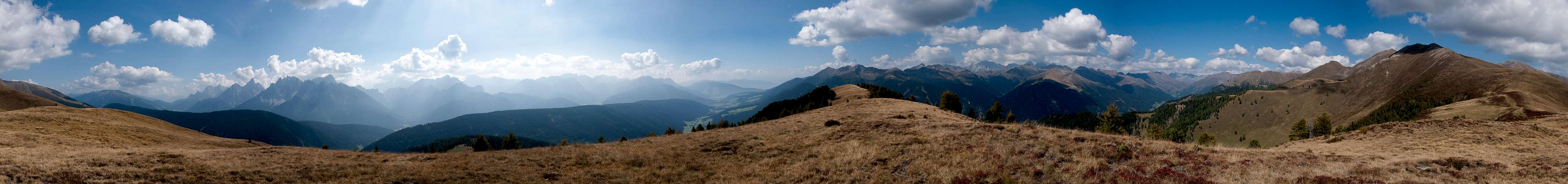
360° Summit Panorama
  |
Getting There
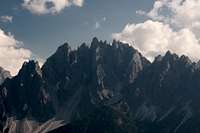
 The Sexten / Sesto Dolomites seen from Roßzogel / Monte Cavallo
The best starting points for an ascent of Roßzogel / Monte Cavallo are at Toblach / Dobbiaco in its south-east or Gsies / Gasies to its west.
- Leave the Brenner Motorway near Brixen / Bressanone and follow SS49 to the east through Pustertal / Val Pusteria.
- For the Gsies / Casies trailhead switch to SP46 at Welsberg / Monguelfo
- For the Toblach / Dobbiaco trailhead drive to the town, then turn northwards onto SP67 for Silverstertal Valley / Valle San Silvestro
- Park your car at the bridge across Silvesterbach Creek
- From Kitzbühel
- Take B108 through the Felbertauern Tunnel to Lienz
- Then southeast to Oberdrauburg (B110)
- Turn on to B100 west into Pustertal.
- Go through the city of Lienz until you get to Toblach / Dobbiaco.
- SP67 into Silvestertal.
- For the Gsies / Casies trailhead switch to SP46 at Welsberg / Monguelfo
- From Salzburg
- Take motorway A10 to Spittal.
- Turn west on B100 to Oberdrauburg, Lienz, Sillian and Toblach / Dobbiaco or Gsies / Casies.
Red Tape
No red tape here. However, remember that you are in the border region between two countries. Carrying an ID is not a bad idea.Accommodation
Weather Conditions
 |
Maps & Books
Maps
- Sextener Dolomiten / Dolomiti di Sesto
1:50000
Kompass Map WK58
Kompass Verlag
ISBN: 3-87051-065-X
- Bruneck - Toblach / Brunico - Dobbiaco
1:50000
Kompass Map WK57
Kompass Verlag
ISBN: 3-85491-064-9
Books
- Osttirol Süd / Tirolo Orientale Sud
W. Mair
Rother Verlag
ISBN: 3-7633-4132-3
ISBN: 3-7633-4307-5 (Italian)
- Pustertal
E. Hülsler, M. Kostner
Kompass Verlag
ISBN: 978-3-85026-015-2
- Rother-Skifuehrer "Pustertal"
Rudolf and Sigrun Weiss
Rother Verlag, 2004
ISBN-3-7633-5911-7