
|
|
Mountain/Rock |
|---|---|
|
|
35.28206°N / 120.67932°W |
|
|
Download GPX » View Route on Map |
|
|
San Luis Obispo |
|
|
1292 ft / 394 m |
|
|
Overview
Along With Bishop Peak, Cerro San Luis is one of San Luis Obispo's most famous land marks. Located near the geographic center of the San Luis Obispo metropolitan area, the peak is a 1200 foot volcanic plug. The summit is part of a chain of volcanic plugs known as the Nine Sisters, (also known as the Moros). Given its urban location the peak sees a lot of traffic. The summit offers excellent views of the city and the surrounding hills. A lot of locals use this peak for regular exercise. Cerro San Luis from the south
The mountain is roughly elliptical in shape, and appears to have a slim and rugged profile when viewed from the downtown area, while seeming very large and bulky from most other sides. Its eastern side is home to a large “M” made of concrete and plaster. The M stands for Mission school which is located near the base of the peak. Just below the summit is a large stage. This is used for Easter Sunday church services on the summit. During the weeks prior to Christmas the summit is decorated with lights in the shape of a Christmas tree, which is visible throughout the town.
Getting There
There is only one legal access point to Cerro San Luis.Heading North on US 101 through San Luis Obispo take the Marsh Street exit number 202A. Almost immediately turn at the first gravel road just as the ramp joins the other lane, before going under the overpass. This can be a difficult turn to make in high traffic.
 From Terrace Hill
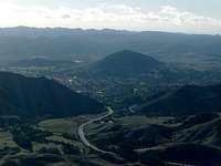
 Northern San Luis Obispo
The main summit trail is a wide dirt road that corkscrews its way around the mountain. From the trailhead follow the most obvious dirt road to small grove of oak trees near the base of a ravine. From here you'll come to a junction with the “M” trail. Continue heading on the main road and crawl under a gate. After another mile you'll arrive on the summit.
Other Hiking trails
Lemon Grove loop: This loop leaves the main trail just after leaving the trail head. It meanders along the lower south east flanks of the peak. The trail leads to an old lemon grove near the base of the concrete “M”. This trail is very popular with mountain bikes. 2 miles round trip.
M trail: Head up the main trail, after a mile you enter some trees in a ravine, the “M” trail turn off is signed here. The trail leads to the concrete “M” on the side of the mountain. 2.5 miles round trip.
Red Tape
 From Cuesta Ridge
http://www.slocity.org/parksandrecreation/cerro_san_luis.asp
The upper mountain is owned by the Madonna family (of the Madonna Inn). Unlike most property owners in the area they tend to have a more relaxed attitude toward allowing access. As a result this is one of the most popular hikes in the San Luis Obispo area. Literally hundreds of people hike to the top of this urban summit every day. Given this areas popularity is is especially important to keep any impacts minimized. Stay out of singed off areas, do not spook cattle, and try to minimize erosion. Also keep in mind that the owners can choose to prohibit access to the summit at any time for any reason.
 Bishop Peak From Cerro San Luis
 Cerro San Luis From Bishop Peak
External Links
http://santalucia.sierraclub.org/ninesis.htmlhttp://www.slocity.org/parksandrecreation/cerro_san_luis.asp
http://hubpages.com/hub/San-Luis-Obispos-Nine-Sisters-Part-2