
-
 4803 Hits
-
 82.48% Score
-
 15 Votes
|
|
Mountain/Rock |
|---|---|
|
|
47.42196°N / 11.29103°E |
|
|
Hiking, Mountaineering, Via Ferrata |
|
|
Spring, Summer, Fall |
|
|
7615 ft / 2321 m |
|
|
Overview
 Sulzleklammspitze as seen from the north
The western end of Karwendel ranges is a huge and massive ridge which runs north - south and rises about 1400 m above Mittenwald valley. As this valley opens at its northern end to a broad mountain basin, this eastern Karwendel ridge, starting with Wörner summit in the north and ending at Brunnensteinspitze / Rotwandlspitze high above Scharnitz / Austria, is an impressive sight.
Sulzleklammspitze is one of the not so prominent summits within this ridge, nevertheless this peak is an impressive rock tower when viewed from the north. To the south and east there are very steep meadows between rocksteps and rockfaces, bearing an interesting mountain flora during spring and summer times.
What makes Sulzleklammspitze an interesting and often visited summit is Mittenwalder Höhenweg, an airy and sometimes exposed but not very difficult via ferrata, traversing Sulzleklammspitze and the northern neighbouring summits Nördliche, Mittlere and Südliche Linderspitze.
Mittenwalder Höhenweg ends (or starts, as you like it) at the saddle north of Brunnensteinspitze / Rotwandlspitze which is called Brunnensteinanger (Anger means alpine meadow).
The easy accessibility of Mittenwalder Höhenweg is guaranteed by Karwendelbahn cableway, making its way from Mittenwald up to Karwendelmulde, a little cirque below Westliche Karwendelspitze (a summit which can easily be bagged with Mittenwalder Höhenweg) and Nördliche Linderspitze, the starting point of the via ferrata. The true mountaineer will start from the valley ground. Thus Mittenwalder Höhenweg is a long tour which tests you stamina: with Westliche Karwendelspitze you will have about 1900 meters of altitude difference to overcome.
My advice: if you plan to summit Sulzleklammspitze / Mittenwalder Höhenweg from the valley ground, start early and do the traverse south to north: you avoid the masses of people starting the via ferrata at the Karwendelbahn summit station. You will meet them at Sulzleklammspitze where you take your well deserved break. Go on when the first clutter and confusion is over. From Westliche Karwendelspitze walk down to Mittenwalder Hütte or via Dammkar to Dammkarhütte for a cool beer - thus you will have a great day without queuing up in front of the iron ladders.
Getting There
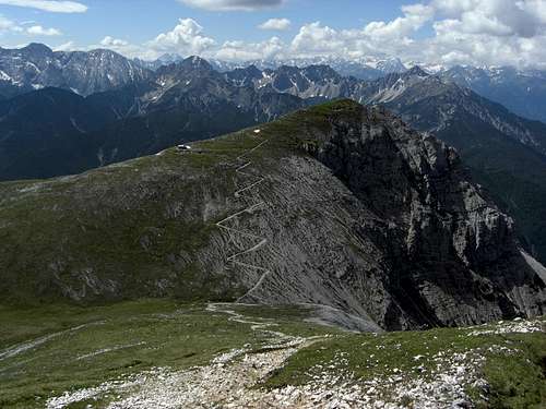
 Sulzleklammspitze and Kirchlspitze as seen from the south
You reach Mittenwald or Scharnitz
All trailheads can be reached with railway, too.
See the railway schedule here .
Routes Overview
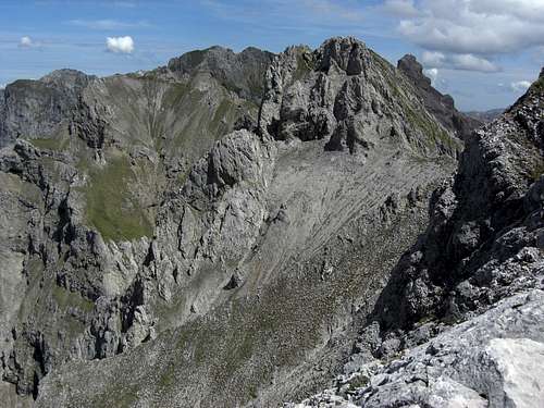
 A view from Sulzleklammspitze to the south
Sulzleklammspitze normal route is Mittenwalder Höhenweg - the via ferrata traverses the summit.
Valley ground trailheads are:
 Sulzleklammspitze south ascent Sulzleklammspitze south ascent |  Sulzleklammspitze north face - via ferrata Sulzleklammspitze north face - via ferrata |  Sulzleklammspitze north face - via ferrata Sulzleklammspitze north face - via ferrata |
Main trails and routes
Red Tape & Accommodation
 Sulzleklammspitze
Red Tape
Sulzleklammspitze and the whole of Mittenwalder Höhenweg is part of the “Alpenpark Karwendel”, an important and strictly protected national park.
There is no entrance fee for the park but many regulations to follow.
Camping is forbidden within the parks boundaries.
Accommodation of all kind can be found at:
Leutasch
Seefeld
Scharnitz
Mittenwald
Garmisch-Partenkirchen
The following mountain huts offer food and lodging:
Dammkarhütte (private hut)
Mittenwalder Hütte
Brunnsteinhütte
Tiroler Hütte on the top of Rotwandlspitze (only food)
Larchetalm (private hut)
Shortly southwest of Gamsangerl col there is an emergency shelter shack below an overhanging cliff.
Gear & Mountain Condition
Sulzleklammspitze is normally accessible in late spring through summer and autumn until the first heavy snowfalls by using Mittenwalder Höhenweg. This via ferrata is not very difficult, beginners, however, should use full via ferrata gear.In spring and early summer snow is lingering on the northeast slopes of Sulzleklammspitze thus making the approach more difficult. Crampons and an ice axe can be advisable in these times of the year.
 Brunnensteinspitze as seen from Sulzleklammspitze south ascent Brunnensteinspitze as seen from Sulzleklammspitze south ascent |  Brunnensteinanger Brunnensteinanger |
Mittenwalder Höhenweg can be a winter adventure for the experienced, too. Please remind that this is a difficult undertaking and that the fixed ropes and iron ladders are not maintained during winter times.
Current Weather:
Map & Guide Books
 Sulzleklammspitze and Linderspitzen
Map
Alpenvereinskarte
Karwendelgebirge, West
Scale 1 : 25.000
Deutscher Alpenverein, 2005
Guide Books
Heinrich Klier, Fritz März, und Walter Klier
Karwendelgebirge. Alpenvereinsführer alpin: Ein Führer für Täler, Hütten und Berge. Verfaßt nach den Richtlinien der UIAA
Bergverlag Rother
2005
Bernd Eberle, Peter Mair, Mike Rutter, und Ralf Sussmann
Kletterführer Karwendel: Alpine Ziele & Klettergärten incl. Martinswand
Panico Alpinverlag
1. june 2004