
|
|
Mountain/Rock |
|---|---|
|
|
38.90670°N / 120.13093°W |
|
|
El Dorado |
|
|
Hiking |
|
|
Summer, Fall |
|
|
9579 ft / 2920 m |
|
|
Overview
Janine Peak is the unofficial name for Peak 9579, which is the summit that rises above the east side of Dicks Pass across from Dicks Peak 9974’. While certainly overshadowed by its larger neighbor, it has a prominence of 390’ making it a true mountain in its own right. It is the forgotten middle child between Dicks Peak and Mount Tallac 9735’ for which it also shares a ridge at about the 9,000’ level. Tallac is a little less than two miles away from Janine Peak.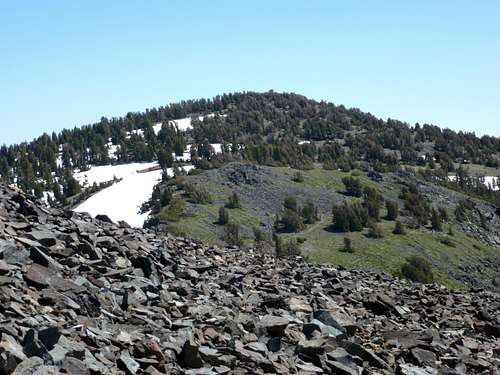
Looking down at Janine Peak on the way down Dicks
The reason to hike Janine Peak is that it only adds 10-20 minutes to a hike up to Dicks Peak (or for any trip that involves crossing Dicks Pass) and it has stellar views of Lake Tahoe and other lakes in the Desolation Wilderness such as Kalmia Lake, Azure Lake, Snow Lake, and Cascade Lake. Furthermore, the summit is an easy walk up, which feels good after climbing Dicks Peak.
Snow stays on the route to Dicks Pass for quite some time, and if you want to approach mostly snow free, you need to wait until late July/early August. Early fall is also a great time to hike in this area.
Getting There
From Truckee head south on Highway 89 to Emerald Bay. From South Lake Tahoe head north on Highway 89. From Reno, Nevada the fastest way there is via I-80 through Truckee. From Carson City, Nevada the fastest way is US 50 through South Lake Tahoe. From Sacramento, US 50 is the most direct option.There are two primary trailheads to Dicks Pass: The Eagle Falls Trailhead and the Bayview Trailhead. The two are separated by less than a mile. Bayview is south of Eagle Falls. Both trails eventually meet up after a little less than 3 miles. Parking at both trailheads fill up fast on summer weekends, so get there before 9:00am if going during that time.
Route Information
The route to Janine Peak follows the same approach as the Northeast Ridge of Dicks Peak via Dicks Pass.From the Bayview or Eagle Falls trailheads continue through this magnificent wilderness following signs to Dicks Lake and Dicks Pass. The trail is usually crowded on weekends, but when it is not crowded, or there is snow, it can get confusing. My recommendation is to bring a trail map. In late summer, the trail is usually snow free until you begin to switchback to Dicks Pass. If you get stuck in snow, head generally towards the pass, which is visible on the way up the trail. Once at Dicks Pass, Janine Peak is a leisurely ¼ mile and 190’ up.
If climbing Janine Peak with Dicks Peak, the total elevation gain is about 3,850’ for both peaks one way, unless you climb Janine Peak after climbing Dicks Peak, and then it over 4,000’ - but you would do that anyway when returning to Dicks Pass, whether you climb Janine Peak or not, so it doesn't really make a difference. Although the Bayview trailhead starts at a higher elevation than the Eagle Falls Trailhead, it does not cut elevation gain overall due to an elevation loss on the trail.
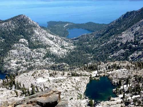
Kalmia Lake, Cascade Lake, and Lake Tahoe from the summit
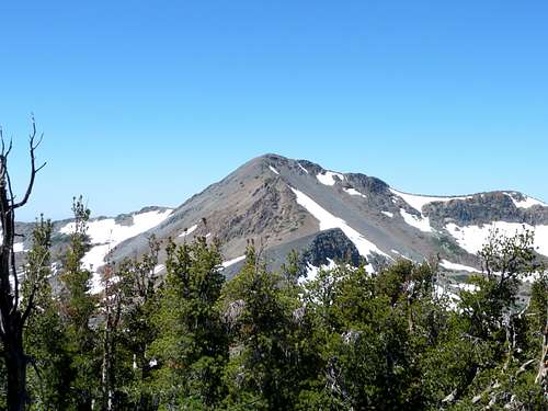
Dicks Peak 9974' from the summit