-
 6968 Hits
-
 87.31% Score
-
 24 Votes
|
|
Mountain/Rock |
|---|---|
|
|
45.76471°N / 11.20571°E |
|
|
Veneto |
|
|
Trad Climbing |
|
|
Spring, Summer, Fall |
|
|
5069 ft / 1545 m |
|
|
Overview
Campanile di Val Fontana d’Oro 1545 m
Campanile di Val Fontana d’Oro - meaning Golden Fountain Valley Needle - is located inside the Monte Forni Alti Subgroup and is famous as one of the finest needles lying in the Pasubio Group, a fascinating pre-alpin group situated along the border between Trento province on the NE side and Vicenza province on the SW side, close to Little Dolomites. Mountains full of history, just because in these places there were years of hard fighting during the World War I. According with the late SOIUSA alpine and pre-alpine subdivision, the Little Dolomites and the Pasubio Group are now considered as a unique group, taking the name of Prealpi Vicentine, but in common usage the old names are still used. An interesting classic route on good quality “dolomia” runs on the SSW face of the pinnacle, gaining its airy summit with moderate climbing difficulties.

|

|
First ascent of the spire: V. Costa – F. Thaler – V. Pozzer 1905
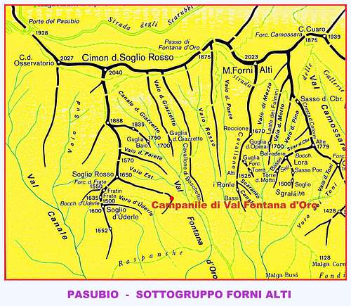
Getting There
Road access

Rovereto side (NE side)
From Rovereto mt. 201 follow SS46 rising along the green valley named Vallarsa and reaching San Colombano – here is situated an ancient hermitage with the same name - Valmorbia mt. 649 - a little village celebrated by the poet Eugenio Montale in “Ossi di Seppia” - Anghebeni mt. 632, Foxi mt. 674, Raoxi mt. 724 and finally Pian delle Fugazze Pass mt. 1162 (km. 26 from Rovereto). From the pass follow the road to Vicenza, going down from some kilometers and reaching the locality named Ponte Verde. From Ponte Verde leave the main road and turn to left, following the road to Colle Xomo. After about 1 km. turn to left again and follow a gravel forestal road (CAI white and red marks), not very good in upper part. Before the road is becoming worse, turn to left following for few meters another road - going down - and park the car nearby a wide meadow.
Vicenza side (SW side)
From Vicenza follow SS46 to Schio mt. 209, rising along Val Leogra and reaching Valli del Pasubio mt. 342, S. Antonio mt. 567, lower Ponte Verde and upper Ponte Verde mt. 901. Turn to right following the narrow road to Colle Xomo. After about 1 km. turn to left and follow an unpaved forestal road (CAI white and red marks), not very good in upper part. Before the road is becoming worse, turn to left following for few meters another road - going down - and park the car nearby a wide meadow.

Valmorbia
by Eugenio Montale (Nobel Prize for Literature) – from “Ossi di Seppia”
Valmorbia, discorrevano il tuo fondo fioriti nuvoli di piante agli asòli. Nasceva in noi, volti dal cieco caso, oblio del mondo
Tacevano gli spari, nel grembo solitario non dava suono che il Leno roco. Sbocciava un razzo su lo stelo, fioco lacrimava nell’aria
Le notti chiare erano tutte un’alba e portavano volpi alla mia grotta.
Bortolan - Padovan Route report
Bortolan - Padovan Route report
Summit altitude: 1545 m
Difficulty: AD sup., III, III+, IV UIAA
Equipment: belays equipped with cemented anchors, some normal pegs along the pitches
Climbing length: 160 m
Exposure: SSW-
First ascent: G. Bortolan – F. Padovan 1927
Starting point: forest road to Raspanche
The Bortolan-Padovan Route on Campanile di Val Fontana d'Oro – the Normal one of the needle – is a classic and frequented climb, well equipped and on good “dolomia”. Climbing way is very pleasant, mainly inner, along chimneys and cracks. The environment is pre-alpine and remarkable.

|

|
Approach - From the parking go back few meters to the marked road and follow it as far as a ford (about 500 meters from the parking). Turn to right, following the track to Val Fontana d’Oro (sign 322). The track rises steeply along some wooded slopes, heading towards Soglio Rosso and our well evident needle. After half an hour leave the main track and turn to left, going up along a rocky gully - rather wide at first and skirting the North side of the peak – then becoming very narrow and skirting the West side of the peak. Scramble up the gully, rising steeply and leading to Forcella della Teleferica, a narrow rocky saddle with some war works, between Campanile di Val Fontana d’Oro on the left-hand side and Soglio Rosso on the right-hand side. Go down 5 mt. in the opposite side. Anchor.
L1 – Climb the chimney-bottom, then its right edge, reaching a terrace (II, III+, peg). Now climb a crack (IV, pegs,) leading to a grassy slopes and to the belay. II, III+, IV, 25 m.
L2 – Up on easy ground towards a large chimney with a blocking rock in its upper section, rising between the needle’s face on the left and a detached pinnacle on the right Climb the chimney-bottom, then its right edge, pass the block and belay on a little terrace on S Face. III, IV, 25 m.
L3 – Climb straightly the slab over the belay – crux – then climb a bit slantways towards left along the slab with some thin cracks leading to a narrow vegetated ledge. Traverse left below a characteristic little pine tree – in italian “mugo”, reaching a small shoulder on SW side. IV+, IV, III, 30 m., pegs.
L4 – Straightly over the belay climb a fine crack, at least slanting toward left and reaching a little terrace. Up straightly along solid grey rocks, reaching a little grassy ledge. IV, III, 20 m., pegs.
L5 – Traverse 10 m. left along the ledge, then climb up along solid grey rock slants toward right, leading to a good stance below the top. II, III, 20 mt.
L6 – A track towards right - along a ledge surrounding the summit peak – is leading to the magnificent flat top. I, 15 m. Summit bell and Summit Book.

|

|
Descent: from the top scramble down to reach last belay. From here four abseils (20 mt.+ 20 mt.+ 50 mt., a short scramble to reach the first belay, then last 25 mt. abseil along the starting chimney) lead to Forcella della Teleferica. An eventual other 30 mt. abseil is possible from Forcella della Teleferica down along the upper part of the narrow gully.
Other routes
- Balasso Brothers VII, VI obbl., 300 m.
- Carlesso South to Forcella Teleferica IV, V, 120 m.
- South Face V, VI, 230 m.
- ENE Route (First climbers’ route) II, 200 m.
- NE Chimney IV, 150 m.
- NE Face V, VI, A1 200 m.
- North Chimney IV, 190 m.
- West Face III, IV, 140 m.

|

|
Red Tape
No particular restriction in climbing and hiking
Where to stay
- Rifugio Balasso m. 983 - Valli del Pasubio (Vicenza)
- Alberghi Pian delle Fugazze m. 1163 s.l.m. - Passo Pian delle Fugazze, Vallarsa (Trento)
When to climb

Best season goes from May to October
Flora
, Little Dolomites")
|

|
Meteo
Guidebooks
"Piccole Dolomiti e dintorni" - Arrampicate scelte by Guido Casarotto - seconda edizione aggiornata
"Arrampicate nelle Piccole Dolomiti" by Guido Casarotto
"Piccole Dolomiti - Pasubio" by Gianni Pieropan - Collana Guide Monti d'Italia CAI-TCI


Maps
"Pasubio-Piccole Dolomiti" 4LAND sheet 118 1:25.000