
-
 7612 Hits
-
 86.85% Score
-
 23 Votes
|
|
Mountain/Rock |
|---|---|
|
|
47.55846°N / 12.35653°E |
|
|
Hiking, Mountaineering, Trad Climbing, Aid Climbing, Scrambling |
|
|
Spring, Summer, Fall |
|
|
7320 ft / 2231 m |
|
|
Overview
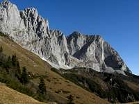
 Wilder Kaiser, Maukspitze on the left
Maukspitze is the easternmost summit of Wilder Kaiser. It rises nearly 1.000 meters above Niederkaiser, the eastern foundation for Wilder Kaiser. Maukspitze is not the highest peak within eastern Wilder Kaiser, neighbouring Ackerlspitze is about 100 meters higher. But the position at the eastern end of the fascinating Kaiser range with its many spires, turrets, peaks, rock faces, is like a last dramatic drumbeat.
Limited by Kaiserbachtal to the north, Niederkaiser and the Kohlental valley between Kössen and Sankt Johann to the east and Leukental valley with Going am Wilden Kaiser to the south, Maukspitze has, despite of the high col between our summit and Ackerlspitze with only 100 meters of altitude difference, a detached and isolated but also a challenging aspect.
As to the last attribute you will not be alone on Maukspitze. On the other hand you will not have the crowds of Ackerlspitze or Ellmauer Halt on top of that mountain either.
The views to the north, east and south are overwhelming. The whole Chiemgau mountains, Loferer and Leoganger Steinberge and a good part of Berchtesgaden mountains are lined up in front of you. The eastern part of Kitzbüheler Alpen, Hohe Tauern from Ankogel to Venediger mountains and the western part of Niedere Tauern can be studied thoroughly. To the west higher Ackerlspitze and the many spires of Griesnerkar cirque summits are blocking the views a bit. But that does not matter too much.
Maukspitze is one of my favourite mountains within Wilder Kaiser. Whether you hike up the southwest ramp normal route, scramble up the Niedersessel - Hochsessel trail, summit Maukspitze together with Ackerlspitze or tackle one of the many climbing routes, this mountain is not to miss.
Getting There
 Maukspitze as seen from Ackerlspitze
Trailheads for Maukspitze are:
Ellmau / Wochenbrunner Alm
Going am Wilden Kaiser
By car
By railway
The nearest railway stations are Kufstein, Wörgl or Kitzbühel
.
Look for the ÖBB scheduels here.
The bus connections can be checked here.
Route Overview
Wochenbrunner Alm trailheadFrom Wochenbrunner Alm take the supply road (trail number 812) up to Gaudeamushütte. Follow the trail via Baumgartenalm and Freiberghaus and Ackerlhütte. After Freiberghaus you reach “Brennender Palfen” (or Pölven), a meadow col with a cross to your right (and with a fantastic view to the Kitzbüheler Aps). Turn left and ascent to Wildererkanzel. Above Wildererkanzel take the right hand trail at a trail junction and traverse the steep south slopes (with some fixed iron ropes) to Westliches and Östliches Hochgrubachkar.
Going / Prama trailhead
Follow the forest road (trail number 813) until you reach a road junction. Take the forest road to your right up to Regalm. Take the right hand trail up to Ackerlhütte and to Östliches Hochgrubachkar, where you meet the Wochenbrunner Alm ascent route.
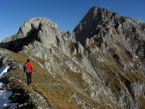
 Maukspitze as seen from Brennender Palven Maukspitze as seen from Brennender Palven |  Ascent to Niedersessel Ascent to Niedersessel |  South rockface of Maukspitze South rockface of Maukspitze |
Summit routes
From Hochgrubachkar and the location of old Ackerlhütte follow the scree trail up to steep rocks and meadows. Climb this rock face (UIAA grade I) up to Niedersessel, a cirque between the stepp to perpendicular rock faces of Ackerlspitze and Maukspitze. Go on to the trail junction in the middle of the cirque.
Hochsessel route
Ascend the Niedersessel cirque directly up to a steep rock face by following the left hand trail. Climb this rock face by following the red-white-red marks (UIAA grade II to II+), there are some iron grips at the most difficult parts.
Climb the chute (UIAA grade I) up to Hochsessel, the upper cirque between Ackerlspitze and Maukspitze. Follow the trail to the col between Ackerlspitze and Maukspitze. There is a trail junction and a signposts “Maukspitze”. Take this right hand trail along the west ridge of Maukspitze with some nice scrambling and a rock window to pass through. Follow a steep trail up to the summit.
 Rockface between Nieder- and Hochsessel Rockface between Nieder- and Hochsessel |  Chute up to Hochsessel Chute up to Hochsessel |  Maukspitze as seen from Hochsessel Maukspitze as seen from Hochsessel |
Southwest ramp route
At Niedersessel cirque trail junction follow the right hand route to the beginning of the broad southwest ramp below the perpendicular rock face of Maukspitze. Follow a rather good trail in zigzags up that ramp - there always is a bit of rock scrambling involved but the trail is not very difficult. You reach the meadows of the southeast ridge of Maukspitze. After a short traverse to the west you reach the summit via a rock chute (easy rock scramble) and some steps on the east ridge.
Traverse option
Take the Hochsessel route up and the northwest ramp route down. Combine this traverse with a quick detour to nearby Ackerlspitze (+1,5 hours) as a cherry on the top.
 Upper south ramp Upper south ramp | 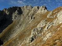 Summit as seen from upper south ramp route Summit as seen from upper south ramp route |  South ramp to Maukspitze and Alpenglow South ramp to Maukspitze and Alpenglow |
Climbing routes
I took the following routes and the UIAA grades from Klettern im Kaisergebirge of Markus Stadler, which gives, in my opinion, a very good overview of the many climbing routes of Wilder Kaiser. For more information go and buy the still available mountain guide Kaisergebirge extrem, which is mentioned in the Map & Guide Book - section of this page.
Upper south face routes (via Niedersessel route and southwest ramp route):
Plattenzauber: UIAA grade VII+
Goinger Weg: UIAA grade VII
Southwest pillar: UIAA grade VI-
Plattenzauber: UIAA grade VII+
Schnapsidee: UIAA grade VI+
Fairplay: UIAA grade VIII-
Plattenzauber: UIAA grade VII+
Clever und Smart: UIAA grade VII
South face, Göttner route: UIAA grade VII-
 Summit break, view to the east
Lower south face routes (rock face below southwest ramp):
Dickes Ende: UIAA grade VII-
Don Promillo: UIAA grade VII
Peter Gogl Gedächtnisweg: UIAA grade VI+ / A2
Mauerläufer: UIAA grade VIII+
Huber / Manzl: UIAA grade V+/A1
Spenglerkamin: UIAA grade VII
Illusion 89: UIAA grade VIII-
Pantherschreck: UIAA grade VIII
Zurück in die Zukunft: UIAA grade VIII+/IX-
Tom und Herry: UIAA grade VI+
Mauk Westwand „Buhl“: UIAA grade VIII+
MIHO: UIAA grade VII / A0
South pillar: UIAA grade V+/A1
Herbsttraum: UIAA grade IX- / A0
Kronthaler / Haselsberger: UIAA grade VI+
Lower south face dihedral: UIAA grade VI+
Lower south face: UIAA grade III+
South ridge: UIAA grade II / III- (parts)
Southeast ramp: UIAA grade IV
East face: UIAA grade II
North face: UIAA grade IV
Red Tape & Accommodation
 West ridge from Hochsessel
Red Tape
The summit and all routes are lying within the nature protection reserve “Kaisergebirge”. There is no entrance fee for the area. All plants and animals are strictly protected. There may be more restrictions, e.g. of camping, fire, firearms, noise, littering. Please respect the protected area and stay on the trails - as long as it is possible (off-trail ascents to climbing routes).
Accommodation
All kind of accommodation can be found at:
Ellmau
Scheffau
Söll
Sankt Johann in Tirol
Mountain huts:
Gaudeamushütte
Ackerlhütte
Freiberghaus
Fritz-Pflaum-Hütte
Gear & Mountain Condition
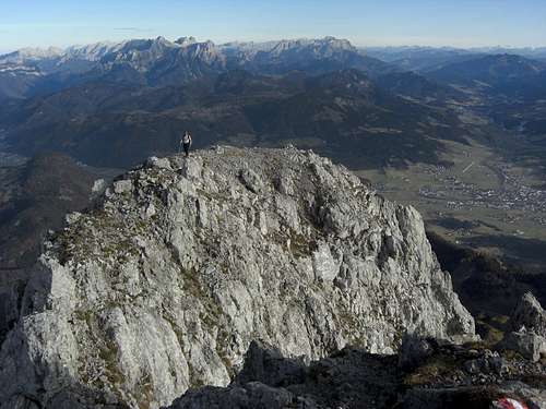 Summit view to the east
Maukspitze is a late spring, summer and autumn tour. Due to the extreme southern exposition of the normal route an early spring or late autumn ascent can be possible, depending on snow condition.
Maukspitze need full hiking equipment and good shoes. A helmet is recommended.
Maukspitze needs climbing abilities up to UIAA grade I and II / II+ on the normal routes. There is one difficult rock face between Niedersessel and Hochsessel (not part of the southwest ramp route!); a steep and exposed south face of about 30 m which can be rated II / II +. There are some fixed iron grips at the most difficult parts of the ascent but you need to manage this terrain. With wet, snow or icy conditions this rock face can be really difficult.
Furthermore you have to deal with exposure in steep terrain (Maukspitze west ridge, Maukspitze southwest ramp).
All climbing routes need of course full climbing gear and the necessary climbing skills.
Current Weather:
Map & Guide Book
 Upper southwest ramp route; fine view to the south
Maps
Alpenvereinskarte, scale 1 : 25.000, number 8, Kaisergebirge, with trails and ski routes; 2005
Guide Book
Horst Höfler, Jan Piepenstock: Alpenvereinsführer, Kaisergebirge alpin (mostly without climbing routes), Bergverlag Rother, München, 12th edition, 2006
Pit Schubert: Alpenvereinsführer, Kaisergebirge extrem (with all major climbing routes), Bergverlag Rother, München, 12th edition, 2000
Markus Stadler: Kletterführer Wilder Kaiser, volumes 1 and 2, Panico-Verlag, 2004 and 2009