
-
 5361 Hits
-
 85.87% Score
-
 21 Votes
|
|
Mountain/Rock |
|---|---|
|
|
31.88030°N / 111.2065°W |
|
|
Pima |
|
|
Hiking |
|
|
Spring, Fall, Winter |
|
|
5940 ft / 1811 m |
|
|
Overview
 Placer Peak from the east
Placer Peak is a relaxed little rounded mountain in the Sierrita Mountains west of the communities of Green Valley and Sahaurita in Arizona. The peak is blanketed in desert grasses and speckled with pi ñon, juniper and scrub oak. From the summit, across the sprawling valley of the Santa Cruz River, there are nice views of the Santa Rita Mountains. The view southward down Ox Frame Canyon and onward into Mexico is stunning. The surrounding rolling hills may make one think more of parts of the Bay Area in California than of southern Arizona.
Few make the short journey from the dirt road system to the summit of Placer Peak. Expect to have this grassy perch all to yourself to take in the views in all directions.
Rank: Unranked
Prominence: 160 feet
USGS Quad: Samaniego Peak
Rank & Prominence: Lists of John
Getting There
 Approaching Placer Peak from the north
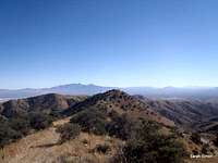 Placer Peak from UN 6180
Primary access from the east is via McGee Ranch Road.
From I-19, take exit #75 (Helmet Peak Road, Sahuarita Road). Take Helmet Peak Road west for approximately 5 miles. Turn left on Mission Road. You will reach a locked ranch gate at a water tower about 4.5 miles west of Mission Road. Parking is available around the water tower.
A route combining this peak with UN 6180 will be posted shortly.
 Place Peak Summit Cairn Place Peak Summit Cairn | 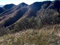 Across Ox Frame Canyon Across Ox Frame Canyon | 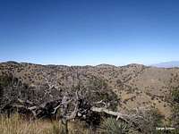 NNE from Placer Peak NNE from Placer Peak | 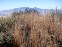 Grassy summit area Grassy summit area |
Red Tape & Land Ownership
 Santa Rita Mountains from Placer Peak
Property ownership of and public access to the Sierritas is, as they say, clear as mud. Property holdings are a checkerboard of confusion with private (including family ranch lands and corporate mining claims) and public holdings (Bureau of Land Management as well as State Trust Lands – which may be under lease) intermingled. Access, particularly from the east via McGee Ranch Road, has traditionally not been an issue. Please be friendly and respectful to all people you encounter and clean up after yourself, your party and others to ensure continued enjoyment of this area for the public.
Not the only privately-owned land in the area, but probably the best known is the area collectively knows as the McGee Ranch & Settlement.
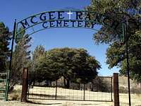 McGee Ranch Cemetery
The settlement on the eastern side of the Sierrarita Mountains dates to 1895 “when goldseekers James Riley McGee, David Lively, George Harris, and their families traveled west by wagon train toward California. When a wagon wheel broke, down at Chigger Hill, they stopped to repair the wheel and pan for gold. In 1898 they settled a permanent camp, predating Arizona statehood. Three years later a prospector guided them to an abandoned ranch where an English homesteader left a fireplace, a rock sheep and goat corral, fig and apricot trees, grape, bean, “squaw corn” fields. The settlement continues there today.*
*Green Valley, Arizona
- By Philip Goorian
Camping & Lodging
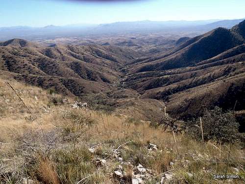 South down Ox Frame Canyon
There is no camping via the McGee Ranch and Settlement access from the east. Most visitors to Placer Peak will be residents of or visitors to the general Tucson metropolitan area and will not need overnight camping or lodging.
There are a handful of hotels in nearby Green Valley, Arizona. Visit the TripAdvisor page for this area for more information.
Weather & Seasons
| Month | Avg High | Avg Low | Mean | Precip | Rec High | Rec Low |
|---|---|---|---|---|---|---|
| Jan | 66°F | 40°F | 53°F | 0.94 in | 88°F (1927) | 6°F (1913) |
| Feb | 69°F | 42°F | 56°F | 0.89 in. | 92°F (1957) | 17°F (1899) |
| Mar | 74°F | 46°F | 60°F | 0.73 in. | 99°F (1988) | 20°F (1965) |
| Apr | 82°F | 52°F | 67°F | 0.31 in. | 104°F (1989) | 27°F (1945) |
| May | 92°F | 61°F | 77°F | 0.23 in. | 111°F (1910) | 32°F (1899) |
| Jun | 100°F | 69°F | 85°F | 0.20 in. | 117°F (1990) | 43°F (1908) |
| Jul | 100°F | 75°F | 88°F | 2.25 in. | 114°F (1995) | 49°F (1911) |
| Aug | 97°F | 73°F | 85°F | 2.39 in. | 112°F (1993) | 55°F (1917) |
| Sep | 95°F | 69°F | 82°F | 1.29 in. | 107°F (2000) | 43°F (1913) |
| Oct | 85°F | 57°F | 71°F | 0.89 in. | 102°F (1993) | 26°F (1971) |
| Nov | 74°F | 46°F | 60°F | 0.57 in. | 94°F (1924) | 19°F (1921) |
| Dec | 65°F | 39°F | 52°F | 0.93 in. | 85°F (1939) | 10°F (1901) |
 Click for weather forecast | In general, expect mild temperatures in winter, often sunny and dry by day and cold and clear at night. The heat in the summer can be extreme and even dangerous. Use caution during the summer monsoon season as washes can flood during heavy rains. |  Click for weather forecast |
Baarb - Jan 8, 2012 9:32 pm - Hasn't voted
Mountain / town nameI would guess the name of the mountain and settlement relate to placer mineral deposits in the area - gold perhaps given some of the history that you've mentioned. Not sure if such info would be worth adding in / looking into. Cheers.
Sarah Simon - Jan 8, 2012 11:33 pm - Hasn't voted
Re: Mountain / town nameBarb, Thanks for the suggestion. I agree with you the Placer name is likely a mining reference. I'll see what I can find. While little is written about the mountains in this range, there is at least one history book published on the area. I'll see what I can scare up! If you find something, however, please feel free to post it / share it! Sarah