Overview
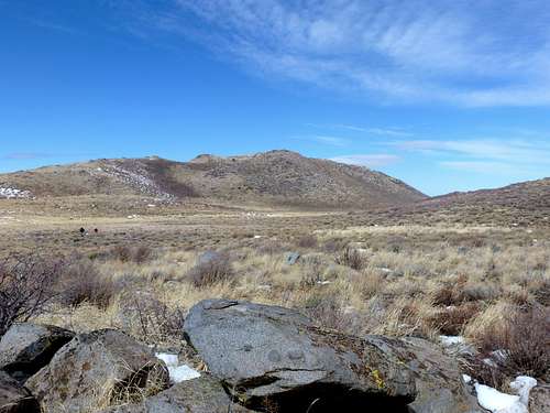
![View north to Petersen Mountain High Point]() View north to Petersen Mountain High Point
View north to Petersen Mountain High Point
It was an interesting day March 10, 2012 in the Petersen Mountains, with many lessons learned.
For one, we learned one safe way to access the trailhead.
Second, we learned the various summits in reach from the trailhead; and
Third, we learned always to keep track of your group, because a person may lose the group and although they are not hopelessly lost - it ends up that Search and Rescue is told to come and get them.
This was my day in the Petersen Mountains.
Finding the Trailhead
On the main page, there is a 3.4 mile 4WD driving route via a road that had been washed out, and may now be improved. This road is supposedly hard to find and unmarked off of Red Rock Road. But is an option to get to the trailhead.
We instead took Goldstone Road, about 10 miles up Red Rock Road from the Red Rock Road exit off of Highway 395.
Goldstone Road is a well graded dirt for the first couple miles or so. It then gets into single track. The road is washed out a bit, but very suitable for 4WD. The problem for us on March 10, 2012 was the fact that some recent snow and apparently little-to-no road maintenance left plenty of divots in the road, and a mud crossing. Still, it wasn’t too bad driving the final 3 miles or so to the actual trailhead.
We got there with a group of 14 and readied ourselves to tackle whatever the Petersen Mountains had to offer. It was a very nice day, with some wind, but in the 50s most of the day.
Bagging a few summits
Naturally, the first place we went was to the Petersen Mountain High Point.
At 7857’ and 3 miles from the trailhead, it was pretty straightforward.
There was a trail much of the way, although some easy off-trail walking was required.
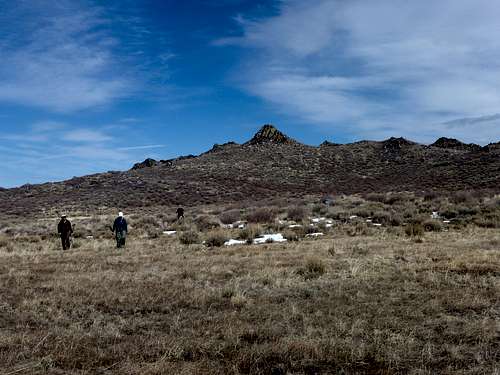
![The group heading up the final slope to the summit of Petersen Mountain High Point]() Heading up to Petersen's highest point - our first summit of the day.
Heading up to Petersen's highest point - our first summit of the day.![Almost at the summit of Petersen Mountain High Point]() Almost at the summit
Almost at the summit![Adams Peak 8,197 from the Petersen Mountain High Point]() On the summit, looking towards Adams Peak 8,197'
On the summit, looking towards Adams Peak 8,197'
I had planned to take the group to Point 7765 across the way from the Petersen Mountain High Point. However, we decided instead to climb a rock tower to the south of the actual Point 7765. The rock tower was at 7655’, with a required scramble of about 60’. Well, actually, I took the steep 60’ Class 3 route. Others took an easier route up the rock tower. We all took photos of the more rugged south side, but none of us climbed it that way.
![Point 7655 is a rock formation 1/2 mile from the summit]() The rock
The rock![Coming down of the big rock]() Coming down off the rock
Coming down off the rock
Next we hiked down from the rock and rested for awhile below, waiting for others to catch up, and peeing behind the only trees we could find, although these trees had no leaves.
![In the meadow/valley looking up at Point 7655]() Heading to the meadow after getting off the rock
Heading to the meadow after getting off the rock
We walked up the two tracks that used to be a road, and got to the base of the 2nd highest summit in the Petersen Mountains, Point 7803. From the meadow, we hiked about 350’ up to Point 7803. We first climbed over a lower rock; Point 7796; before we bagged the real summit, only 7’ taller. The lower rock was fun; another Class 3 jaunt for me. Class 2 for others.
![Heading up and over the lower rock less than 2 miles from the trailhead]() Looking north back to Point 7796
Looking north back to Point 7796![The group heading off Point 7803 - second highest summit in the Petersen Range]() Looking back north to Point 7803
Looking back north to Point 7803Losing Hiker #14
It was only when we were on top of Point 7803 that I learned of our missing hiker. I won’t go into details, since I don't have all the facts, but I was told he was doing his own thing and lost track of us after we descended from the rock tower (Point 7655’). It appears one culprit was distraction of technology – making calls and listening to music…while hiking. This should always be discouraged on a group hike. A hike like that is time to put the technology away and enjoy the outdoors. Your friends not hiking with you can wait for you to return before bothering you with calls and texts. I did not know all the details, just that technology was a distraction and this probably wouldn't have happened if it wasn't being used too profusely.
We perhaps could have gone back for him, or started making calls then. We probably should have. But we didn’t. We waited until we were back the trailhead, and could not find him. Then we tried to call him, but most of our cell phones did not have service. This is probably because we were a dead zone in the shadow of several hills.
Fortunately, my Verizon service worked when I walked partway up a nearby road heading north. My phone battery was nearly dead, but somehow I managed to get the gentleman’s girlfriend on the phone – got his number – and was the first of the hikers to call him.
When I called, I learned he was still where we left him. His girlfriend had called Search and Rescue (SAR). Perhaps an overreaction led by emotional response, but oh well. I wish I had a girlfriend who cared so much. The gentleman lost told me that the SAR was coming and asked for guidance down the mountain, which I gave. He then suggested not all of us wait for him. Me being a tad selfish, and eager to get out of there, decided not to be the one to wait. After all, I had made the calls necessary to get connected with him, get the necessary information to know he was safe (it was perfect weather, in the high 50s on the mountain, with plenty of daylight to go, plus he was pretty close to getting back). Further, I have gotten lost WAY WORSE than he was and I was not in any doubt of his safety. Keep in mind, Petersen Mountain is very simple. From the trailhead you follow a trail up to the ridge, then head right. That’s it! Not too tricky. Anyway, they found him totally safe and fine a little over an hour after he called. They were about to mobilize a rescue effort when they saw him walking towards them.
Still, I have to say that next time I organize a group hike, I will make strict rules that people do not wander off, and to follow the group when we head off a summit. Things like that can cause serious problems, and we were lucky that it wasn’t worse situation than it was. I learned that all the pride in the world can't make up mistakes we make because we don't think something like this will happen. Even a hike up a simple mountain can cause confusion. This was the case with Petersen Mountain because it has a trough in the middle, with summit on the east and west sides of the range. Therefore, someone has to climb up east in order to see the valley to the east, and vice versa.
Lesson learned.
Summary
I ended up hiking about 7 miles, and gained about 2400’. We could have done Point 7765, a little further north of the rocky Point 7655, but we didn’t feel the desire. Further, we could have done Point 7801 further south from Point 7803, but felt we had done enough for the day.
Overall, I felt like a bit of jerk. But some of my favorite female hiking buddies grilled me on the way back in the car. They also talked about how good looking the dozens of SAR guys they saw driving up to find the lost gentleman.
By the way, March 10, 2012 precedes a night where Daylight Savings came in and took an hour away from our weekend. A good day for a significant experience.
Comments
No comments posted yet.