In 2005 an event stunned the mountaineering community way beyond the French Alps: the Bonatti pillar on the Drus was totally washed away by a series of huge rock falls between June and September. Succeeding to 2003, one of the driest and warmest summer of the century, with constant rock falls all over the Alps ranges, an ‘annus horribilis’ for all climbers, with many routes totally impracticable as far too dangerous, including the ‘classic’ approach to Mont Blanc by the Gouter couloir, banned for most of the summer, this exceptional event put to light the damaging impact of the Global warming on the Alps and consequently on all mountaineers. Hence this question: and what about the future?
Up to then, the typical layman believed such events as quite normal and part of the fact that the Alps were "young" mountains still growing etc... when the most recent explanations given by the scientists - their leading reseachers being Ludovic Ravanel and Philip Deline - aside when caused by earthquakes (which on The Drus seems only to have caused the 1905 rock fall), were the result of a more complex dual movement:
During warm summers the sun heats the rock stretching it particularly in permafrost zones (permanently iced) and closing flaws. On The Drus the presence of permafrost was observed above 2700/2800 m (subsurface layer affected by the seasonal ice melting) and generally in the Alps on rock walls exposed North at around 3000 m on a depth of 4,5 to 7 m depending on the year (Gruber and al., 2004).
On the opposite when the rock cools off, flaws reappear. It is this alternate movement of opening and closing which slowly modifies the geometric layout of the depths in the flaws, with the consequence in turn of a loosened rock.
The Drus before and after 2005 - Ludovic RAVANEL and Philip DELINE work on the Drus
The Drus before 1977
The Drus after June 2005
But scientists now start to have some ideas (although still with uncertainties) of what is really at stake underground at high altitude.
For Philip Deline (CNRS 26th January 2011, Domancy - Haute-Savoie) the study of the rock falls in high altitude and the degradation of permafrost encounters 3 specific problems :
Permafrost being a thermal state is not visible to “the naked eye” contrarily to other high mountains phenomena (glacial, avalanche prone, torrential, etc…), particularly on rock walls. Taking into account permafrost implies first of all to find out its localization, its depth distribution and its evolution over time.
Then one has to clarify its connection to the frequency of the falls and the eventual degradation of the permafrost (particularly occurring with the ice melting inside the cracks in the walls).
As far as the rock falls are concerned, one must find out if those phenomena are more frequent today and if their magnitude increases or not.
The work done by the young Chamonix scientist (geomorphologist) and mountain guide, Ludovic Ravanel with Philip Deline (who wrote in 2003 a superb thesis on the same subject covering the Italian side of the Mont Blanc), both from the Laboratoire EDYTEM, université de Savoie, CNRS, 73376 Le Bourget-du-Lac, on the evolution of the Drus has allowed a much better understanding of those rock falls and how in the future it will increase with the Global warming.
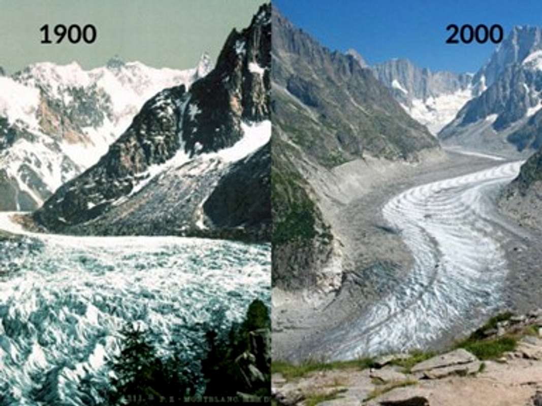
Thanks to the unique mass of photos and testimonials existing on the Drus which he gathered, Ludovic has managed to describe the evolution of the Drus over the last 150 years (being from one of the oldest Chamonix family with many generations of mountain guides - today they are 9 Ravanel at the Chamonix guides company - was certainly of great help to his work). One thing he states for certain is that “the ice acts as cement in the flaws of the rock. But when temperatures increase near to 0°C, it does not play anymore its cementing role”. And since 1936, the overall temperature in the Mont Blanc range has increased by 2° C. So the phenomenon considered for very long as a natural process and hazard is drastically increasing.
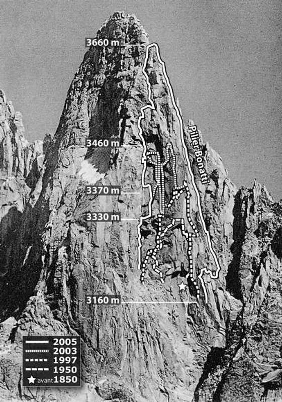
From 1860 till 2005 - Successive Rock falls on the Drus from 1850 until 2005 (Ludovic Ravanel and Philippe Deline)
From Ludovic Ravanel, we learn that from 1860, date of the first valid photo of the Drus until the beginning of the 20th century nothing much happened. From 1905 untill 2011, 11 major rock falls occurred. The first one - 20 000 m3 - in 1950 modified the West face of the Drus over a 100 m between the heights of 3 220 m and 3 330 m.
The second significant rock fall - 27 000 m3 - occurred in September 1977. Two alpinists were bivouacking on the face. They were be taken off by helicopter.
To visualize the volume represented note that 1 000 m3 of rock fall is equivalent to at least a block of 10x10x10 m. The Drus is of course not the only mountain to suffer. In 1997, 2 millions m3 disappeared from the Brenva on the Italian side of Mont Blanc. However, it is the best observed and best researched of all, so greatly helping the understanding of the causes. Pillars and crests are the most exposed parts of the mountains.
In 2003, the summer was so warm, that rock avalanches occurred everywhere. The danger was such that even the classic route of the Mont Blanc by the Gouter couloir had to be banned. A rock fall of 6 500 m3 occurred on the Drus but went unnoticed as the mountain range was deserted due to the very high rock fall threats. On the summit of the Matterhorn, 1 000 m3 of rock fell down requiring the rescue of 90 alpinists by helicopter (see more about this event on the link supplied by Hansw in the 'links' section).
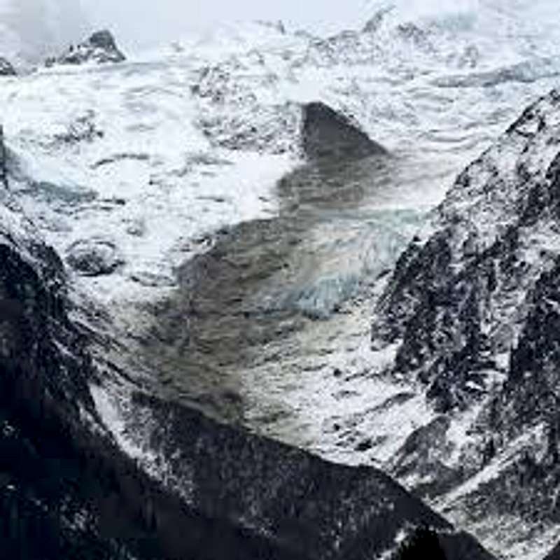
Two years later, on the 29th and 30th of June 2005 a series of huge rock falls destroyed completely the Bonatti pillar - Between June and October 2005 in all 265 000 m3 of rocks fell down. The damage covered over 600 m in height and 100 m wide and two more followed in September.
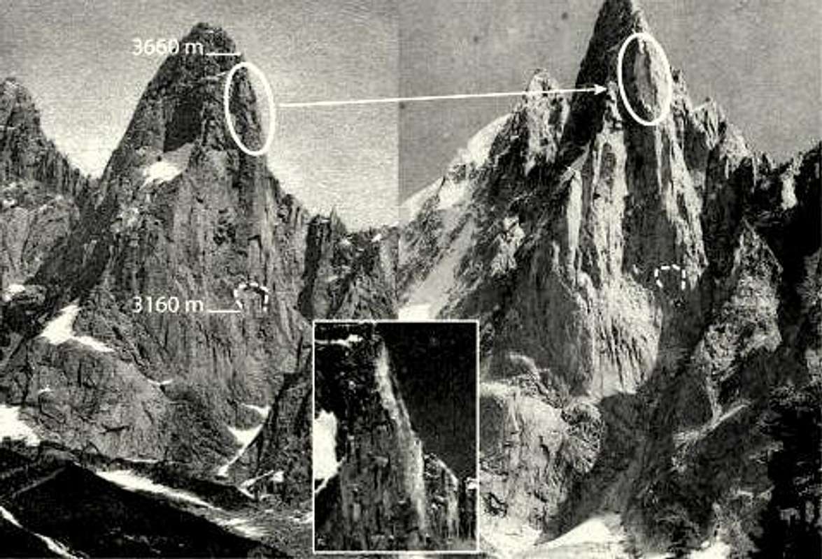
1905 Rock Fall
Left:ca1900 (Jullien brothers) from la Pierre à Bayer, 2090 m a.s.l, view angle, N115°;
Right:1908 (unknown author) from le Montenvers, 1913 m a.s.l, view angle, N100°;
Centre: the 1905 rockfall scar, seen during the 1905-1906 winter (unknown author);
Dotted line: scar of a rockfall that occurred before the end of the LIA (Little Ice Age).
The 1905 event was due to an earthquake which distroyed the Argentière church tower. Of a magnitude estimated at 5-6 and an intensity in Chamonix of VII, it also caused the top of the Sans Nom Peak to be shortened of 9 m (15 m in 1860). No more rock fall did occur until the middle of the 1930s.
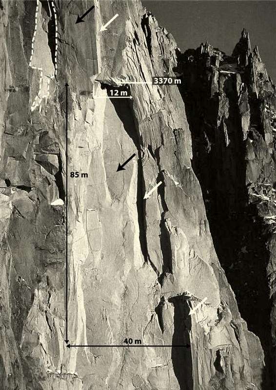
1997 rock fall detailed impact
DETAILS OF THE 1997 ROCK FALL
Upper half of the rockfall scar of September 1997 (ph. J.-C. Marmier, 1998).
White arrows: fractures plans N 30°E – 75°N.
Black arrows: fractures plans N 120°E – 80° NW.
Dotted line: scar of the 1992 rock fall.
2005 Rock Fall detailed view
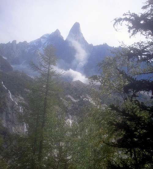
In June 2005, rock falls increase until those of the 29th and 30th of June. They took away the South-West pillar climbed solo by Walter Bonatti over 6 days in 1955 and known to everyone as The Bonatti pillar.
3 rock falls occur on the 29th: at 11h03, the 2003 formed overhang goes up 120m; then at 13h53, the West half of the pillar falls down; at 14h22, the first part transformed in an overhang falls down, 150 m higher than in 2003.
The largest fall occurs on the 30th at around 03h00 washing away the rest of the pillar.
Up until the end of July 2005, blocks will continue to fall, followed by several ones at the beginning and end of September resulting in a total of 265 000 m3.
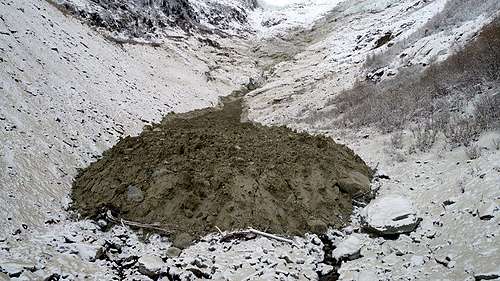
On the pictures to the right one can see the rock dumps which extended itself over 90 000-95 000 m2 on the Drus glacier and its moraine system. Distances covered were of 1 200 m vertically and 1 330 m in length.
The largest blocks - 30-35 m3, up to 100 m3 - are in the center: those megablocks cover smaller ones. The thickness, over 5 m on average goes up to 10 m locally.
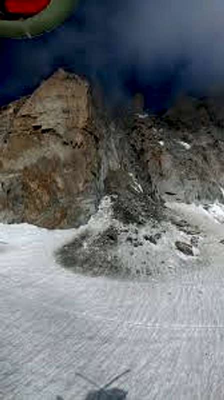
The 2011 rock falls
11th of June 2011 - a rumbling noise...
During 6 years, nothing much happened.
Then, on the 10th and 11th of September 2011, 43 000 m3 of rock fell down. Ice appeared from the crack: the PERMAFROST!
I took this photo on the 11/09/2011 at 13h26 from Les Mottets facing the West face of the Drus, after having climbed the 'Caline' route.
Suddenly we heard a huge and continuous rumbling noise and grey clouds covered the West face of the Dru. (They lasted the hour we stopped at the place and much longer after we departed).
We then saw several huge blocks as big as houses coming off from where the top of the Bonatti pillar used to be!
The Future
Conclusion by the specialist Ludovic Ravanel:
From 1855 until 1950, the situation stayed stable. Then in the second half of the XXth century the rock falls continually increased. During the two decades of 1990 and 2000, the warmest, "they exploded in frequency and volume".
"The falls occur during the warmest periods or at the end of them".
"The permafrost is the triggering factor".
"The global warming +2% in Chamonix since 1936 will increase the phenomenom".
"Most probably rock falls high in our mountains will occur more frequently and be bigger according to the increase of temperatures, even during the colder seasons".
Did Georges Livanos caused a big rock fall in 1952?
To end on a humourous tone, Pierre Alain had a story running that two climbers from Marseille, Georges Livanos and Robert Gabriel who were trying to make the first ascent of the West face of the Petit Dru had put so many pegs that it made the whole wall unstable hence one of the next big rock falls. "The Greek" never denied that story.
Links
For those who want to know much more, read the work of Ludovic Ravanel, Philip Deline and their colleagues made accessible in two cases in English as well as in French
c. Also published in 2009 by 8 scientists of whom Ravanel and Deline (French and English) giving a more general view of rock landslides with examples in the Himalayas (Daulaghiri) and in the Alps (Brenva glacier and The Drus): Geomorphic impacts of large and rapid mass movements: a review
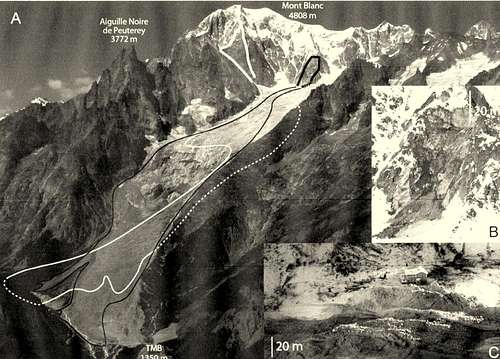
Appendix 1 The Brenva spur and glacier
A huge rock fall estimated at 2 million m3 on the Brenva spur triggered a snow avalanche and land slide on the 18th January 1997 killing 2 skiers and damaging a hotel.
Characteristics of the last rock avalanches on the Brenva Glacier (Mont Blanc massif).
A: scars (thick lines) and tracks (thin lines) of the rock avalanches of the 19 November 1920 (white lines) and 18 January 1997 (black lines).
B: 1997 scar on the Eperon de la Brenva (G. Mortara, February 1997); C: 25-m-high ridges of the 1997 mixed deposit in the distal area (E. Dal Molin, 18 January 1997).
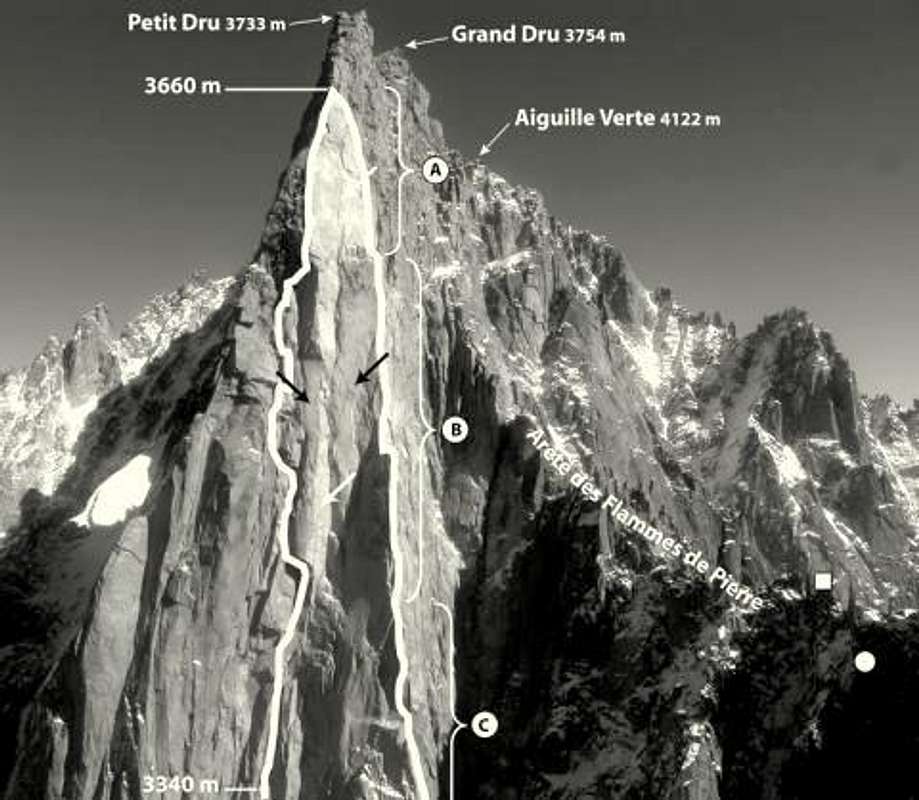
Appendix 2 - The Drus analyzed in 2006
Upper part of the West Face of Les Drus (October 2006).
White line:2005 rockfalls scar;
white square: location of the laser scanner;
white point: temperature sensor implanted in the NW face of les Flammes de Pierre;
white arrows: fractures plans N30°E-75°NW; black arrows: fractures plans N120°E-80° NW; A, B and C: see text below.
As with other parts of the Mont Blanc range, the Aiguille Verte - the Drus has very steep slopes - their average steepness is 75° with for The Drus (3 754 m high) of more than 1 000 m of height.
The Petit Dru is a monolith well separated on the West-South-West horn of the Aiguille Verte (4 122 m). Its West face is made of compact rock, while the adjacent faces are more fractured. The North face is quite broken with an ice-nival niche resulting from a flow. The West face is currently marked on two-third of its height by a large light grey surface 70 m wide, testimony of the 2005 Bonatti pillar disparition.
This galling scar, high of 600 m can be divided in 3 parts.
The lower quarter (section C) corresponds to a N30°E–75°NW vast fracturing plan revealed by several rock falls.
In the central (section B) the galling scar is constituted by 2 parallel dihedrals, the largest results from the section C fracture plan. The other goes up into the superior quarter of the scar (section A) and delimits the upper part of the 2005 rock falls. So 3/4 of the galling scar are orientated West-North-West and the upper quarter South-South-West.
A 2019 Update on the Impact of Global Warming on the Mont Blanc massif and its activities
Impact on climbers and mountain guides
The global warming observed in the Mont Blanc range being 2 times + greater than in the plains (average of + 2.1°C in the Mont Blanc range since 1900 for around 1°C for the whole of France and 0.6°C worldwide) and less freezing winters (I personally experienced that in the last 10/15 years, we never had even a full week with -25°C and only one to two weeks with -15°C, while some 30 years back we experienced one to three weeks at -25°C and 4 to 8 weeks with -15°C) has resulted in high altitude routes permafrost (the key mountain cement) melting. As Ludovic Ravanel stated: "If the mountains' cement is weakened, whole faces can start moving, some can separate themselves. This is what happens today with the mass increase of scorching periods." (on Radio France 19/11/2019).
This has had such an impact on routes in the Mont Blanc range that out of the 100 best routes published by Gaston Rebuffat in his famous guide book "Le Massif du Mont Blanc - Les 100 plus belles courses", some 30 are unclimbable in summer (with several which do not exist anymore such as the Dru Bonatti pillar which was washed away) some being far too stone falls prone that they must be avoided in the middle of the summer (such as the Tour Ronde normal route which is now more a massive scree than the snow route it used to be). Last year for a period of two weeks at the end of July, the Compagnie des Guides du Mont Blanc refused to lead customers on the Mont Blanc by the Gouter route so dangerous had become The infamous "Couloir du Goutet".
Cosmiques ridge rock fall August 2018
Soon after, the classic "Cosmiques ridge" route to the Aiguille du Midi was banned by the Compagnie des Guides for a period of time after a series of huge rock slides in its middle which occured in August 2018.
Taconnaz spur land slide 24/11/2018
And this phenomenon can only accelerate. On the 9 the January 2018 at 7.15 am a large powdery avalanche fell from the Gouter ridge, along the Bourgeat couloir the heavy snow well stopped by the avalanche barriers (estimated mass stopped of 150 000 to 200 000 m3) but for the light powdery plastering with snow some 40 chalets and destroying a large number of trees. The barriers well so filled up that the risk of another avalanche was serious enough to evacuate the inhabitants of several chalets for a time. This event has put in question the limits of the Bourgeat couloir avalanche barrier which was built prior to the Taconnaz avalanche barriers and did not benefit from the lessons of the 1999 winter and the technical advances gained since [Testimonial of Daniel, Les Houches ski patrolman: https://www.youtube.com/watch?v=jfH0aiQ8DsU]
A huge land slide occurred on the 24/11/2018 between 4 and 5 am on a spur on the left of the top of the Taconnaz glacier (altitude 2750 m, 700 m from the Grands Mulets refuge), a volume of several ten thousands of Cubic meters slided over 1.9 km ending at the Taconnaz mountain stream, 850 m before avalanche barriers.
The permafrost melting phenomenon has imposed changes in the guiding trade with a choice of routes less prone to rock falls in the summer and a choice of different periods for many routes previously done in mid July and August. It is now much safer to climb Mont Blanc in May or October than in the middle of the summer. Climbers coming to Chamonix with specific climbing targets in mind will find very useful to go to the OHM "La Chamoniarde" (same building than the Chamonix Guides Company) whose personnel will inform them on the risks involved, route per route, some of which will have to be avoided so high the risks are. Information on mountain conditions to all climbers wherever they come from has been their prime target when created (1972 by Gérard Devouassoux from the Compagnie des guides de Chamonix, two years before his death on the Everest West ridge) and their close links with the Chamonix Guides Company allows them to give climbers the best information on mountain and routes conditions.
low end of the Taconnaz spur slide 24/11/2018
Impact on mountain Infrastructures
The permafrost melting is also impacting key mountain infrastructures' sites. Some 148 out of 947 ski lifts, pylons, ski stations of arrival and refuges erected on icy ground are concerned now.
Two of the most known in the Mont Blanc range are the Cosmiques refuge (3613 m) and the Aiguille du Midi's station of arrival (3842 m). Both are now being scientifically surveyed (some 10 extensometers on the Aiguille du Midi) and structural strengthening planned and carried out. 40 other sites have been reinforced. Luckily the scientists implied are sharing all their knowledge and the French will be able to benefit particularly from the Swiss who have been a prime research force to analyse the permafrost and develop techniques to strenghten the infrastructures' sites thanks to their SLF resarch centre (https://www.wsl.ch/en/snow-and-ice/permafrost.html).
In 2010, the Swiss scientists did establish a guide on how to build on permafrost describing the techniques to be used and how to adapt. Some have already been used on the Mont Blanc' sites or are planned to be used to counter the permafrost melting consequences, but adaptation will be key to counter the progression of the global warming intensity. As Ludovic Ravanel states:"We will need to be more watchful than in the eighties. High mountain changes and we must adapt."
Those who would like to know more about the work being done can look at the following videos in four episodes to understand the Permafrost melting impact on mountains and glaciers with The Aiguille du Midi, The Cosmiques refuge and the Cosmiques ridge rock land slide (in French):
and the survey from Emmanuel Salim, Jacques Mourey, Ludovic Ravanel, Pietro Picco et Christophe Gauchon about the changes which have occurred in the Chamonix and Courmayeur guiding habits:
2022 Ludovic Ravanel Impact of Global Warming on the Alps North faces
In an article published in La Montagne et Alpinisme (August 2022), Ludovic Ravanel summarizes the work done to study the impact of global warming on themajor North faces of the Alps which were not much known up to now. This is what he states to start with:
'What are the common characteristics of the four greatest Alpine North faces, theMatterhorn (4478m), the Grandes Jorasses (4208m), the Eiger (3967 m) and the Drus (3754m)? Of course, their length, their steepness and their altitude; thefact that they were all climbed in the 1930; but also, the ice which covers a part more or less important of their surface. Those covers of Ice and snow [CIS - CGN in French for Couvertures de Glace et de Neige] are present in many north faces which are above 3200m of altitude, but also on more sunny faces at higher altitude. They contribute to the beauty of high mountain landscapes and to their appeal for alpinists. However, for several decades, those wall ices do not seem to be protected anymore by their altitude . They have started to melt, and even to disappear as at the end of the 2017 summer when the North face of the Grands Charmoz (3445m) above the Mer de Glace became entirely rocky, a totally unheard-of situation since the beginning of the Montenvers activity, centuries ago. Elsewhere where the ice still resists, belays used by climbers some twenty years ago are today ‘perched’ several metres above theice, an announcement of its disappearance to come.'
Ludovic indicates that since the 1990s, all CGN did withdraw. ‘The Tour Ronde and the Triangle du Tacul have had a mean average loss of surface of more than 1% per year between 1984 and today, the Grandes Jorasses at 0,8% per year. The rate for the Grands Charmoz was 5% per year till its total disappearance in 2017.' Ludovic indicates that CGN only exists in a Permafrost context, that their poor thickness is often less than 10 to 15m and that their ice glued on the rock (called the cold ice) is negative (-5°C measured at La Tour ronde where the ice meets the rock underneath). Due to their steepness (between 40° and 80°) and this cold, their surface is “icy” and smooth, offering little possibility for snow to stick on it.
Amongst the discoveries he and his friends made is the age of the ice of those CGN, older that the ice of main glaciers such as La Mer de Glace and the Miage glacier (around 500 years) against an average of 600 and 800 years for ice at the surface of CGN, and at the Triangle du Tacul where the ice is in contact with rock its age was measured as 6200 years. As Ludovic states:
‘Currently we anchor our ice axes in a very old ice… The oldest surface ices are not at the front of the glaciers, but in the north faces!’
His conclusions for the climbers are quite definitive:
'Gaston Rébuffat - who was the first to climb the four great north faces mentioned above - published in 1973 'Le massif du Mont-Blanc - les 100 plusbelles courses.' Fifty years later we have studied the evolution of the routes described. 50% were run through CGN and their recent evolution make those ascents more difficult technically and more dangerous. In terms of difficulty, it means steeper slopes. While those covers were most often in easy snow to 'crampon' up to the beginning of the 2000, ice is now predominant, requiring a full mastering of ice climbing techniques (increase of the difficulty level). For dangerousness, on top of the previously mentioned factors which increase the risk of falls, the withdrawing of the CGN tend to favour stones falls and landslides.... While the CGN were climbed all the year round up until the 1990s/2000s, one must now take advantage of good conditions when they occur, most often in winter and at the beginning of spring.'
2022 Impact of Global Warming on the Ecrins massif (Oisans)
Global Warming in the Oisans massif
Early August this year an article was published in Le Monde newspaper noting the critical situation of the Oisans largest glacier, ‘Le glacier Blanc’and the whole of the massif. The glacier went back one kilometre over the last 25 years and its front is now drawing back at an average rate of 60m per year; in thickness it loses 2 m of ice a year and its global surface diminishes ever more rapidly. Over a century its mass losses were multiplied tenfold and the more rapidly in recent years. 2022 will result in the worst aggravation ever with temperature up to 30°C on the glacier during the day and 15°C at night. So, the melting of the glacier occurs also during the night when beforewith a negative temperature the ice could regenerate itself! Seracs falls with major blocks of ice happen daily. The guardian of the Glacier Blanc refuge was forced to bring up water tanks with 2x10000 litters as he is getting very little water from the glacier névés. If this goes on he will be forced to close the refuge.
The Global warming which has been of +2°C in forty years at 3000m of altitude, has impacted the whole of the massif. Half of the ice surfaces have gone, and projections show that 90% to 95% of the ice volume in the massif will disappear by 2100. Of the 120 glaciers of the massif, half have already disappeared, and the rest do not have accumulation zones any longer i.e., they do not make ice anymore and live on their reserves.
For alpinists, all routes are more difficult and more dangerous, so much so that guides books are now said to be obsolete. Even trekking, you have to walk on ice slippery as ice of a skating ring. Visitors have diminished by a factor of ten on the Glacier Blanc states his refuge guardian. The season for alpinists has now moved from summer to spring and autumn. Last year the Pilate refuge (2577m) had to be closed down as built on a rock block which became unstable with the melting of the glacier. However, Ludovic Ravanel stated that the other refuges of the massif are not threatened, and the overall risk of rock major collapses is less than in the Mont-Blanc massif. As Mathilde Dahuron, the guardian of the La Pilatte refuge stated:
‘This year, one cannot avoid the reality of the climate crisis!’
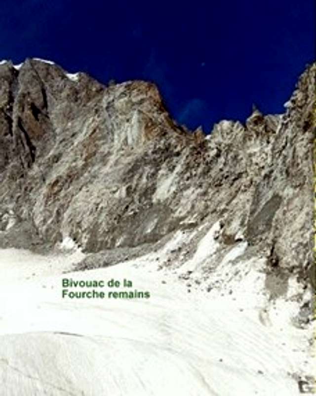
The mythical refuge-bivvy used for climbing the great Mont Blanc Italian routes such as the Brenva, the Pear, the Major and the Central Frêney pillar, collapsed with its rockbase. It had been highly unstable for some time as its nearest route the Kuffner ridge. The rest of the bivvy which had been fully renewed in 1985 lay 300m down the Italian side on the Brenva glacier.
“The permafrost melting further down and the Brenva glacier thickness reduction, four episodes of extreme heat this did cause this fall” stated Ludovic Ravanel. «It is not a large collapse, compared as an example with the one which occurred on the Tour Ronde North face. But one expects more of such events till the end of the summer, as there is enormous energy in the walls, which will inevitably free itself at any time. » Though two climbers stayed at the bivvy a few days earlier noting its high instability, there has been no victim. Very few other climbers did use it since this area was well known for its rock fall high risks.
Among advises to mountain guides and alpinists given by Ludovic (himself a member of the Compagnie des guides de Chamonix) this past summer were:
·Avoid North faces above 2,300m due to rock falls risks.
·Avoid ridges because of the heat on each side.
·Avoid couloirs due to faults creating instability and debris being channelled.
·South faces OK, but ice approaches could be problematic and keep an eye above
·Beware of signs of potential rock falls (gravel in cracks, water running down cracks, rumbling noises, fresh rock on ledges etc…).[1]
·For the future Ludovic advocates a change of season for the peak climbing activity, towards the end of spring when the rock is coolest.
[1] Talk with Ludovic Ravanel organised by Andy Perkins and Martin Elias (IFMGA guides based in Chamonix) published in Alpine Club News Autumn 2022.
Some sources of Ludovic's work in English:
Journal of Glaciology (777-789) Variations in surface area of six ice aprons in the Mont-Blanc since the Little Ice Age.
Arctic. Antarctic and Alpine Research, 51(1): (176-189)The effects of climate change on high mountain envronments - Evolution of mountaineering routes and their conditions of use in the Mont-Blanc massif over half a century.
Read also the excellent UKC article from Natalie Berry 28th July 2022: Climbers and Guides Adapt to hanging Climate and Landscape in the Alps: UKC Natalie Berry article
Hi my friend,
i notice you that several recent rock-falls are reported regarding also the limestone of Eastern Alps: i report Pelmo last summer, Cinque Torri in 2010 and today the Guglia del Milite in Little Dolomites...
I'm afraid, but the permafrost's problem is touching even Eastern Alps...
Cheers
Oh, with all one's heart i wish it may be as you say! Yes, the phenomenous is more clamorous in Western and Central Alps, but unfortunately permafrost does exist also in Eastern Alps and in 2009 the Meteo Station of Arabba (Dolomites) had published a research about the liaison with the increasing rock-falls in the Dolomites and permafrost's warming...
All the best.
Thanks for this excellent history regarding all Petit Dru rockfalls. Today i've just add a picture at the bottom of your article, taken during the bivouac at Flammes de Pierre in 1985. The title is "When Petit Dru was still intact...".
Ciao
alberto rampini
Thanks Alberto. Tell me how I can get hold of your 1985 picture and I will add it. I see that you are going quite often to the Calanques. Next time you come, go and climb the "Renard spur" (Morgiou). It is easy (grade 5) but spectacular on magnificent rock. I did its 1rst ascent in 1970 with 1 peg only (the 2nd pitch - the crux then). Now it has become such a classic that there are a bit too many bolts, but they are for protection only so the climbing is still as nice. Rgds
I've given you the edit privileges on the picture. Now if you want you can add it to your page. In spring i often go to climb in Calanques. Next time i'll climb this route.
Thanks and ciao
alberto
the data Zermattfan has posted for the Gornerglacier. There has been three clear glacial maxima separated by minima during the last 1000 years, all nearly identical, only the last of the minima could have had anything to do with anthropogenic warming. My bet is that the present minimum will also be followed by a maximum, let's just hope it will not go so far as one of the maxima where the end of the glacier was just 200 meters above Zermatt.
what was the brand of Bonatti's smashed beer can? It would sure make an excellent added picture to this wonderful essay......as I think his thumb is already well healed....
Parents refers to a larger category under which an object falls. For example, theAconcagua mountain page has the 'Aconcagua Group' and the 'Seven Summits' asparents and is a parent itself to many routes, photos, and Trip Reports.


Comments
Post a Comment