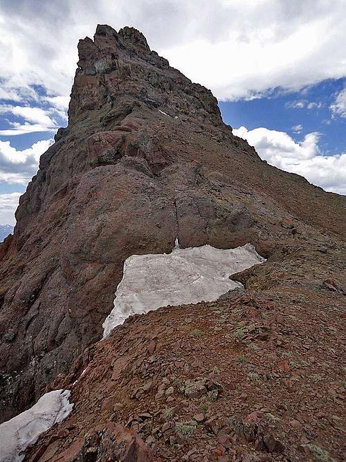
Dead Indian Peak
I got my first look at
Dead Indian Peak when I was about twelve years old; from the turnout at the top of the Chief Joseph Highway, tourists and locals alike are captivated by the splendor and beauty of the rugged peaks surrounding Sunlight Basin. The mountain's sharp spire made an impression on me, and although I didn't summit my first peak for another fourteen years, I always had a longing to see those mountains up close. In 2009 I climbed nearby Trout Peak, which is the highest peak in the North Absarokas, and the summit view convinced me that I had to climb Dead Indian in the near future.
I made plans to climb it in July 2010 with Bob Sihler, and we hauled heavy packs up 4000 feet through dense, trail-less forest, only to be stopped a half mile from the top the next morning by snow and dense fog (
Tim Was Right and I Was Wrong). In August 2011, Bob and I tried it again as a dayhike, but a knee injury forced me to turn back as Bob successfully reached the top (
Onward Alone and Closing the Deal). I've never failed three times on any mountain, and so the stage was set for 2012.
Background
I met Chris (SP member
Morlow) through a forum post he put up looking for climbing partners in the Yellowstone area. We discovered a wide variety of shared interests and both enjoy the same kinds of peaks and routes, and we made plans to do several trips in summer 2012. I had planned on something else with another friend on the last Monday and Tuesday in June, but after he bailed I texted Chris on about five days notice and asked if he wanted to try Dead Indian, and he agreed. Rather than try it as a day trip and risk an attempt being foiled by thunderstorms, we decided to do the heavy pack thing in spite of the fact I had sworn to never again bring a pack up that ridge. Two years had pretty much erased the memories of the sweat and misery involved!
We met in Sunlight Basin on Sunday night and drove out to Gravelbar Creek, where we spent the evening chatting before sleeping in our vehicles; the weather was promising to hold up, and we were both too excited to get much sleep...
![Dead Indian Peak]() Dead Indian Peak
Dead Indian PeakThe Climb
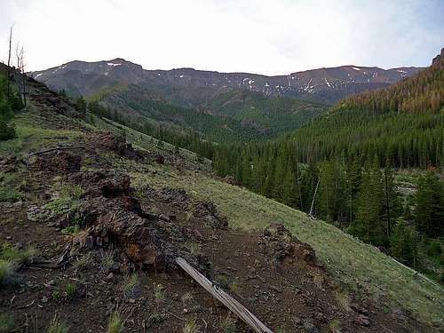
After a 4:45 alarm, we were on the trail by 5:30 and hit the knee-deep stream crossing of Gravelbar Creek about thirty minutes later. There is nothing that wakes you up quite like fast and freezing water! After several more miles, we crossed another large stream that comes down from the slopes way above, and decided to start heading up the next ridge.
![Looking at the ridge]() Which spur to take? (Photo by Morlow)
Which spur to take? (Photo by Morlow)
If you have read Bob's trip reports and his Dead Indian Peak page, you will know that gaining the ridge is the most difficult part of the climb; there are numerous forested spurs from which to choose, and they all suck! This was the third different spur I'd ascended in my three tries, and true to form, it sucked. We toiled up for 500 vertical feet through deadfall and close pine branches before reaching a small clearing at about 8500 feet. We decided that the ridge we were on might get too tricky higher up, and so we traversed over to the next spur on the right, trying to lose as little elevation as possible.
![Dense bushwhacking]() Chris fighting the trees
Chris fighting the trees![Chris]() Chris posing by the stream
Chris posing by the stream
After topping off all of our water in the stream between the spurs, we started up another horrible section of dense forest and finally came out in a clearing at about 9200 feet.
![Nearing the ridge top]() Looking up at the ridge (Photo by Morlow)
Looking up at the ridge (Photo by Morlow)![Gravelbar Creek]() Looking up the Gravelbar Creek drainage (Photo by Morlow)
Looking up the Gravelbar Creek drainage (Photo by Morlow)
The views from this spot are immense; the Beartooths stretch out over the northern horizon and Pilot and Index Peaks stand just to the left of them. The path to the ridge was now clear, but the slope steepens to about 35 degrees, and the mix of the higher elevation and the heavy pack make it feel like you will never reach the top! Chris was leading, and it was very clear that he was moving much faster than I was; the extra 35 pounds I have on him and the fact I've only been above 10,500 feet once in the last two years didn't factor in my favor, and surely beer and donuts can't have that much of an effect on your cardio, right? Anyway, he beat me to the top of the ridge by a good fifteen minutes at least, but I eventually dragged my sorry butt up, knowing that once I topped out on the ridge I could drop all of the heavy stuff and go for the summit with a light pack!
![Tim and Dead Indian]() Ready to head for the top! (Photo by Morlow)
Ready to head for the top! (Photo by Morlow)
We choose a campsite at about 10,700 feet near the ridge top, dumped the tent, sleeping bags, and extra clothing and headed for the summit at about 11:30. The weather was holding, though clouds were forming around us. We were only about three miles from the summit, but it seemed to take forever to get there as the wide open bowl under the peak plays tricks on your depth perception!
![Final scree slope]() Nearly there...
Nearly there...
The final scree slope under the summit rocks starts at about 11,600 feet, and climbs steeply up to 12,000 feet. Chris kicked my butt once again, and I felt like absolute crap as I labored up the slope, stopping every twenty or thirty steps to gasp for breath and try to get my heart rate down. The clouds were starting to look a little darker but luckily weren't really growing upward much. I knew Chris's biggest fear is lightning, and so I pushed as hard as possible to assure that we could get up and down before a storm hit. I was so close to achieving this summit that I'd thought about nearly every day for the last two years, and there was no way anything was going to stop me - lightning or no lightning!
At last we were standing of the base of the 200-foot summit nipple. I dropped my pack and Chris started up onto the first ledge. The first four rocks he grabbed onto pulled right out of the mountainside, but once he got started, the rock turned out to be very solid. On fun scrambling terrain we swung left, traversed to the right, went back left again, and then right around to last few easy rocks to the top, where the astounding view was well worth the huge effort of the day!
![Scrambling]() Chris ready for some scrambling
Chris ready for some scrambling![Summit!]() Chris on the summit!
Chris on the summit!![Enjoying the summit]() Sharing the victory!
Sharing the victory!
I let out more than a few whoops, knowing I'd finally conquered a mountain that had seemed just out of reach for so long. Bob mentions that the summit register was jammed very tightly shut, and we weren't able to open it until I got the idea to stick the top between the summit rocks and twist; Chris's brawn won over the stubborn tube, and we added our names to the list.
![Summit views]() Summit views
Summit views![On the descent]() Heading down...
Heading down...
We didn't spend a ton of time on the summit due to the more serious-looking clouds that were piling up, and we beat a hasty retreat down to camp, which we reached about 4:30 after nearly eleven hours of continuous movement. After a short rest we set up camp, cooked dinner, and retired to our sleeping bags at about 8:00. The storms never materialized, and we had beautiful views of Mount Dewey and Dead Indian until sunset.
![Camp]() Camp
Camp
Tuesday morning we packed up and headed down the ridge about 7:00, dropping 2,000 feet in the first hour. The next 1,000 feet took well over an hour, as reaching Gravelbar Creek through all that forest just isn't fun. A word of wisdom to anyone attempting Dead Indian: don't descend off the spurs down into the creeks, as you will cliff out at waterfalls and be forced to climb way back up and around!
![Crossing Gravelbar]() Chris crossing Gravelbar Creek
Chris crossing Gravelbar Creek
We reached our vehicles at 11:00, very tired, weary, and footsore, but pretty exhilarated about our successful outing! Our total trip was about 16.5 miles and 5600 feet of elevation gain. I promised Chris I'd work on my cardio and try to do something to get rid of my "fat lard" status in time for our next adventure in a couple of weeks...
Cheers!


Comments
Post a Comment