
-
 14522 Hits
-
 79.04% Score
-
 10 Votes
|
|
Mountain/Rock |
|---|---|
|
|
37.32360°N / 121.2258°W |
|
|
Stanislaus |
|
|
Hiking |
|
|
Spring, Summer, Fall, Winter |
|
|
2074 ft / 632 m |
|
|
Overview
At an elevation of 2072 feet, Orestimba Peak stands above lowland hills that rise out of the San Joaquin Valley in western Stanislaus County. It is an isolated Diablo Range peak located on private ranchlands once part of the original 26,668-acre Mexican land grant Rancho Orestimba y Las Garzas. The word Orestimba is also used in the naming of Orestimba Creek which flows south of the peak, as well as the Orestimba Wilderness, a 22,000-acre section of Henry Coe State Park located eight miles to the west of the peak. Summits within the vicinity of Orestimba Peak include: Mount Oso, 15.1 miles to the north, Crevison Peak, 9.4 miles to the south, Mustang Peak, 12.1 miles to the southwest and Mount Stakes 10 miles to the west. Looking south from slopes below Orestimba Peak
 Sloping ridgeline leading towards Orestimba Peak
Getting There
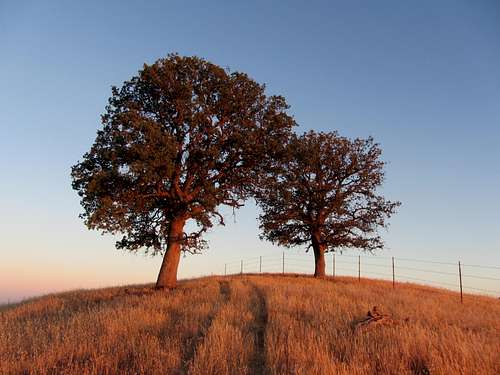
The shortest route to Orestimba Peak is to travel approximately five miles west on Orestimba Road to a point where a steep ridgeline ascends directly to the peak. Pass through the gate and follow the wide gravel road as it parallels the creek which is dry most of the year. A grove of ancient, large sycamore trees grows alongside the creek providing shade during the day. The valley here is wide and surrounded by treeless, golden-brown hills that are grazed nearly bare by summer. Nearing the four-mile mark, the hills--now plentiful with oak trees--rise to greater heights, and the creek narrows as the canyon walls steepen. The road crosses the creek bed two or three times and then veers north. You will pass large outcroppings of rock and notice small cave-like formations where swallows and other birds nest. A ridgeline with a raised, vertebral column of sandstone rises to the northwest. Look on the topo map for indication of a benchmark at 340 feet. This is the point at which the road heads west again. You will arrive at a hunter’s shack painted red. Leave Orestimba Road and gain a ridgeline just east of an unnamed creek that intersects Orestimba Creek. The route is obvious from this point forward. Continue to ascend the ridgeline, following the outlines of a rarely used jeep trail. There are a couple of fence-crossings. The jeep trail eventually arrives at the summit of Orestimba Peak after two miles of ascension. Look for a benchmark that states the elevation to be 2073 feet cemented into a mid-size rock.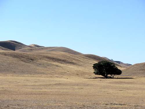 A lone tree north of Orestimba Creek
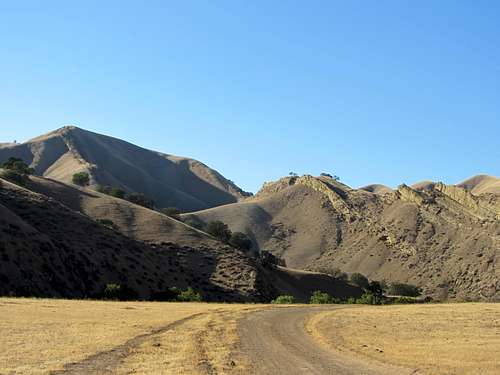 Where Orestimba Road heads north.
Driving Directions
Take the Newman exit off Interstate 5 and go east on West Stuhr Road. At the first intersection turn right onto Bell Road. Drive one-half mile, then turn right onto Orestimba Road. After one mile you will reach a bridge that crosses California Aqueduct. There are various places to park before crossing the aqueduct. Regardless of arrival time you may notice local residents fishing in the aqueduct who will potentially contact the Fish & Game Department if they observe trespassing. If you continue over the bridge you will soon reach a locked gate posted with “no trespassing” signs. There has been poaching in the area so the property owners have zero tolerance for trespassing.Orestimba Creek
Orestimba Creek, originally Arroyo de Orestimba, is a tributary of the San Joaquin River which drains eastern slopes of the Diablo Range. The creek has its source at the confluence of the north and south forks of Orestimba Creek which both begin and flow through the Orestimba Wilderness in Henry Coe State Park. The creek was historically the northern boundary of Rancho Orestimba y Las Garzas as well as its primary source of water. An ancient grove of sycamore trees grows alongside the creek to the point at which the creek enters the steep canyon named Orestimba Narrows. The creek was historically a watering place on El Camino Viejo, the primary road of travel between Los Angeles & Monterey during the time of Alta California. Looking northwest of Orestimba Creek.
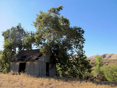 Old shack near Orestimba Creek.
The Historic Westside of the San Joaquin Valley
El Camino Viejo, the old road of Spanish and Mexican periods, followed the west side of the San Joaquin Valley and crossed many creeks that are known today by their Spanish names. Among those in Stanislaus County are Arroyo de las Garzas (“the herons”); Arroyo de Orestimba (“the meeting place,” so called because the padres, when first gathering Indian neophytes in the region, made an agreement with the remaining natives to meet them there again the following year); Arroyo Salado Grande (“big salty creek,” where the pioneer known as “Salty” Smith settled in 1855); Arroyo del Puerto (“the gate,” so named because of the natural cut in the hills west of Patterson through which the creek flows in the rainy season); and Arroyo del Hospital (named for the experience of a party of Spaniards who, overcome by sickness, rested beside this stream and were healed).Spanish settlement on the west side seems to have had an early beginning, for at least one Spaniard, a deserter from the cavalry, settled on Arroyo de las Garzas as early as 1820. A battle took place in the vicinity that year, when a detachment of Spanish troops came to get both the fugitive soldier and some Indians who had run away from the missions. American pioneers in 1852 found the mestizo son of this former cavalryman living in an adobe on Arroyo de las Garzas just across the line in Merced County several miles west of the present town of Gustine.
Above the sycamore grove on Arroyo de Orestimba stood the ranch house of Rancho Orestimba y las Garzas, granted in 1844 to Sebastian Nunez, a son-in-law of Francisco Pacheco. Jess Hill, on of the owners of Hill’s Ferry on the San Joaquin River, settled on the Arroyo de las Garzas in 1854, where he built a house from lumber brought around the Horn and hauled to Las Garzas by ox team. The site was later occupied by one of the Simon Newman Company sheep camps.
[Mildred Brooke Hoover, Douglas E. Kyle, Historic Spots In California, 5th Edition, (Stanford University Press, Stanford California 2002), pg. 517]
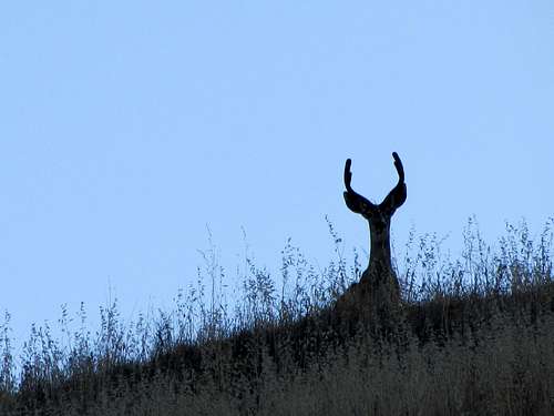 young buck on slopes nearing Orestimba Peak.
 Windmill near Orestimba Creek.
William Brewer at Orestimba Creek
We passed up about fifteen miles, then turned up the Orestimba Canyon and camped about three miles from its mouth. Here we were on a cattle ranch, away from the infernal sheep. We struck a good place to camp. It was a lovely Saturday night. We had wood, and built a bright camp fire, the first we had had since striking the San Joaquin plain—except that one back in the mountains. But the feed was poor, so, early in the morning of Sunday, June 15, we raised camp and moved up the canyon about a mile to where the feed was better and camped in a most charming spot—a little plain with high hills each side, feed tolerable (though dry as hay), a clear stream of pretty good water, and a great sycamore for shade. We were in camp again and all in order before ten o’clock.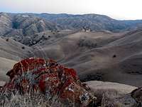 Southwest view.
 Southeast view towards Orestimba Creek.
It was a lovely and quiet Sunday. It followed a hard week’s work, and was spent quietly as could be—no one but ourselves to molest. The day was intensely hot, we could see the Sierra with marvelous distinctness out of the mouth of the canyon, which expands to over a mile wide, and the night which followed was yet clearer than the day—the sky of the intensest blue, and the stars as numerous as on a clear winter’s night at home.
As we came on farther and farther, the air grew day by day hotter and drier, and all the evidences of a drier climate increased. All the herbage on the hills was dry enough to burn, and the plain brown and dry as hay. At Orestimba the ranch runs to the river, six or eight miles distant, and often for several summers in succession all the cattle must be driven there for water. Until this past winter and spring it has been five or six years since there was water in the canyon where we were now camped!
Monday, June 15, we climbed some hills about 2,200 feet high, a few miles from camp. It was intensely hot. I know not how hot, but over 90 degrees all day in camp where there was wind, and vastly hotter in some of the canyons we had to cross. It was 81 degrees long after sunset. The Sierra seemed but a few miles away, and the night was intensely clear.
Tuesday, June 17, was still hotter. Hoffman and I rode a few miles up the canyon, then a laborious walk up a ridge 2,400 feet high, to get bearings. Whew, how hot it was! On the top, where there was a breeze, it was 89 degrees. How hot it was in some of the still canyons I have no idea, but in one, not the hottest, I got in the “cool shade” of a tree, where there was some breeze and found it 105 degrees. It seemed positively parching. But on sinking into the deep, narrow canyon we came to a stream, found a deep hole, and took a most delicious bath. We saw a deer, also a panther—were quite near the latter, but he made off. This is the panther which is known here as the California Lion. I have heard much of them, but had no idea that they were such formidable looking animals. This fellow could have carried off a man easily. Bear signs were numerous.
A hot night followed this hot day—few slept well. Mosquitoes, numerous, huge in size, and ferocious in disposition, haunted us, but they molest me less than the other men.
[William Brewer, Up and Down California in 1860-1864: The Journal of William H. Brewer. (University of California Press, Berkeley 1966, 1974) pgs. 283-284.]
 Oaks on hills near Orestimba
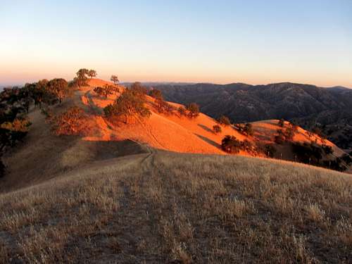 Sunset on hills near Orestimba Peak
Orestimba Etymology
An arroyo de Orestimac is mentioned in Father Viader’s diary of Oct. 1810 (Arch.MSF 4:92). A diseno of the Rancho del Puerto (1843) shows an Arroyo de Horestimba, and a diseno of the Orestimba land grant (Feb.21, 1844) shows an Arroyito de Orestinoc. The name contains Costanoan words, the first being ores ‘bear’ (Kroeber). A tributary is called Oso (‘Bear’) Creek, and a nearby mountain is Mount Oso. Locally the stream has been referred to as Orris Timbers Creek. [Erwin G. Gudde, California Place Names (University of California Press, Berkeley 1949, 1998), p.271]Camping
Campsites are available in the nearby towns of Gustine and Newman. Use googlemaps.com to search for campsites.Red Tape
You will need permission from the property owners to hike here.External Links
List of Stanislaus County PeaksOrestimba Peak stats.