
|
|
Mountain/Rock |
|---|---|
|
|
39.19820°N / 119.85989°W |
|
|
Washoe |
|
|
Hiking, Bouldering, Mixed, Scrambling |
|
|
Spring, Summer, Fall |
|
|
8208 ft / 2502 m |
|
|
Overview
Hidden from the vanguard of the Tahoe Rim Trail is a lesser known backcountry area leading from the Washoe Valley up to the Hobart Creek Reservoir. A charming little lake in the middle of the forest east of the Carson Range crest east of Lake Tahoe. In fact, Snow Valley Peak 9214’ is about 3 miles to the west.A road leads all the way to the Hobart Creek Reservoir. The unnamed Hobart Peaks are located east of the reservoir, towering about 650’ above it. The views from the summit are tremendous, surrounded by rolling hills. Washoe Lake and the Virginia Range are viewed to the east, and the Mount Rose Wilderness to the north. The Carson Range high peaks are visible to the west.
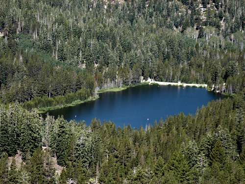
View down to Hobart Creek Reservoir
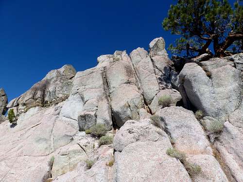
The lower peak (Peak 8205) is on the southeast side of the Hobart Creek Reservoir. It can be considered the "Hobart Peak Towers", because it is a series of large rock towers, with class 3 and class 4 climbs up solid rock. Unfortunately, the hand holds and foot holds aren’t very good, which makes reaching the summit require perhaps light class 4 moves, if not very difficult class 3 moves. The lower south tower is definitely class 4. This peak is also quite accessible from Ash Canyon in Carson City.
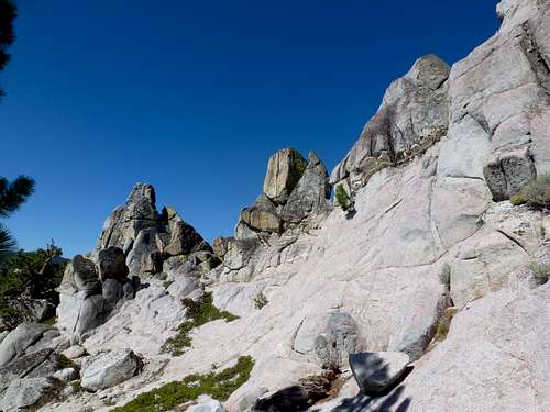
Rocky towers
The higher peak (Peak 8208) is on the northeast side of Hobart Creek Reservoir. It involves some scrambling, but is mostly sand and brush.
Each peak involves about 450’ of elevation gain from the road. They are just over ½ mile from each other. Although the peak on the northeast side is listed as higher by USGS, it is debatable which is actually taller. They are basically the same height. The towers might even be higher.
This area is a great for mountain biking, hiking, and rock climbing – at least for the towers that make up Peak 8205. Running the road is a also popular option.
Typically the best time to hike or bike in the Hobart Creek Reservoir area or alternatively Ash Canyon is April through early June and late August through mid-November. It is better in fall when the weather is a little more temperate. Avoid the hottest part of summer.
The coordinates for Peak 8208 are: 39.198197, -119.859885
The coordinates for Peak 8205 are: 39.192096, -119.85312
Getting There
The road to the Hobart Creek Reservoir and the Hobart Peaks is situated just off of Highway 395, and accessed just north of Carson City. Whether coming from Reno or Carson City, the objective is to get off at the East Lake Blvd exit (Exit 44 off of Highway 395). Take a right once off the exit, and then an immediate left going south on 429, which parallels 395. Take the second right on Hobart Road, and drive a little less than 1 mile to the end. There you will find a trailhead with enough space for 15 cars or so, including parking on the side of the road. The trailhead is at 5425’ or so. You will see a sign saying “Hobart Creek Reservoir 4.9 miles”.If just hiking to the towers, Ash Canyon is also an option. From north Carson City take Winnie Lane to Ash Canyon Road. Drive to the water tank. You can park near the water tanks or just past them in the nearby parking areas. Be careful of the divots in the pavement heading to the water tanks. They can do some damage to your car if driving too fast.
Route Information
From the Hobart Creek Reservoir trailhead, start up the road leading north along the hillside. It starts off steep for the first 1/3 mile or so, and then flattens, then gradually climbs. There are a number of large hills after this, leading up to another flat part at around 3 miles up. Follow the flat part of the road as it winds north, and eventually leads up to a gate with a sign at a junction saying "Hobart Creek Reservoir 1.5 miles". The road climbs again to about 7770’. Then descends for about ½ mile to the reservoir at 7542’.Climbing the peaks from Hobart Road
Once near the high point of the road, you will see a road on your left. This leads up towards Peak 8205 and a series of rock towers. They are not visible from the road. Or at this point, you can look to your right and see the craggy, sandy Peak 8208.
Peak 8205
Follow the road for ¼ mile or so until it appears to top out. Head left up the slope, and you will start to see the towers above you. The first tower looks daunting, and it is - definitely requires some sort of rope, harness, and helmet, if you want to be really safe. Fortunately for peak baggers, this is not the true summit. However, the true summit is no picnic itself. It is just a tiny bit further north of the first big rock tower. Head another 30 feet, and you are at the base of the summit. This is where it gets complicated. Climbers will have to figure out the best way. Hand holds and foot holds are tricky. There is at least one easy class 4 move possibly required near the summit itself. I didn’t find this too dangerous, and did it without rope. A helmet might be worth a try. Of course, I would recommend this as a climbing destination, so feel free to bring climbing gear and explore all these rocky towers have to offer.
From the road, the total distance one way to the summit is only about 0.4 miles.
View up the rock towers that make up the summit of Peak 8205
Peak 8208
The supposedly higher peak on the north side of the road is far more easily reached. It just requires dealing with some brush and sandy slopes that can be frustrating to maneuver through. The top is a bit rocky, and requires some scrambling, but nothing like dealing with the rock towers.
From the road, the total distance one way is only a little over a third of a mile.
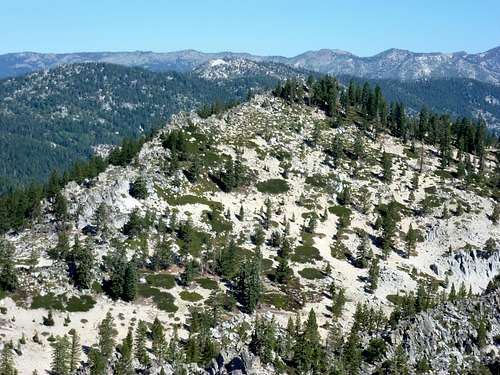
Peak 8208 from Peak 8205
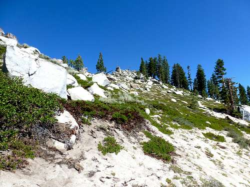
Final sandy, brushy slope up to Peak 8208
Distance/elevation gain
If visiting both summits and the Hobart Creek Reservoir, the round trip mileage is about 12 miles. The distance assumes walking an extra 1/4 mile each way to the east side of the reservoir, where the road ends and there are nicer views. The total elevation gain is about 3,500’. If skipping the reservoir, you cut out about 250’ of elevation gain and 1 1/2 miles of hiking distance.
Ash Canyon
From the water tanks, a 4WD can take the steep road up, or you can walk up the road. After 3 1/2 miles, the road climbs 2,600' and reaches the base of Peak 8205. The road turns left heading west. From here you can scramble up the terrain to the towers. Round trip, the hike is about 8 miles, gaining 3,000'. If visiting Peak 8208 this way, you add 1 1/2 miles, and about 450' of elevation gain. So about 9 1/2 miles total, which would be about 11 miles if also visiting Hobart Creek Reservoir. This makes Ash Canyon even shorter, and probably just as good a route.