Blue Moon C2C (Cactus to Clouds) Hike
C2C is a classic Southern CA hike that is said to have the longest continuous gain of any trail in the continental U.S. with a vertical elevation gain of a little over 10,300 ft. from its start to summit, not counting any additional gain due to downhill sections, with a total mileage of 24 miles based on 12 miles to the tram and another 12 miles roundtrip from the ranger station to the summit. A good cite with much information about this hike begins at http://www.mtsanjacinto.info/skyline/skyline.html and then gives you details upon correctly answering 4 questions.
This hike took place on August 31, 2012 which had a blue moon. A blue moon is defined as a second full moon in a month, so it is relatively rare, which has led to the vernacular phrases regarding a blue moon.
Keeping with the blue moon, my brother Ed, Mark J and I headed out to Palm Springs on August 30 from Glendale, CA, at around 11:30 a.m., and were treated to what I will call once upon a blue moon weather. When we got to the Morongo casino, it began raining. The weather report had given the chance of rain at 20% for all relevant times for our trip. As we headed into Palm Springs, the sky looked very threatening. We went to the Palm Springs Art Museum and casually hiked up several hundred feet to see what the beginning of the trail looked like. We then went to the Chamber of Commerce, a block away, to inquire about any street parking restrictions. While we were there, the wind began howling, the sky darkened, and it started raining again. We saw a restaurant cabana structure being blown down the street. As we started driving down the street, the clouds burst open, and the streets started to flood. It was dark enough to be evening, but it was early afternoon, and the temperature was nowhere near the 105 predicted for the day. Here is an early picture in the rain:
![Palm Springs Deluge]()
So we were not feeling very good at all about the weather. Unfortunately, we could not change our trip, as my brother had flown in from Chicago in the morning and we had an entry permit into the Sierras on Monday, so it was the next day or miss C2C with Ed. After we got a hotel, we went to dinner, the weather was starting to clear, and some Internet research led us to believe we would be okay with the weather, although the chance of rain was the same as for the day. (Subsequent research lists the rain received by Palm Springs on Aug. 30 as 0.6 inches; not a lot by many standards, but a lot in Palm Springs, especially when it occurred so quickly.)
We got to sleep a little after 6 pm and woke up at 1 am. Although we were in Palm Springs in the heat of summer, it was extremely humid. We got to the trailhead at 2:20. There is a very good map of the very beginning of the trail at the trail head. It indicated that three trails converge at what might be described a roundabout like one might see for traffic, so we figured that we should go left, right and then left again when we hit converging trails. This was good information to remember when we subsequently hit the three trail junctures.
Within 15 minutes of beginning our hike, none of us had a stitch of dry clothing, and it stayed this way all throughout what we had hoped would be a good time to be hiking. The humidity, combined with the desert heat, was a killer. Although we had been prepared for heat, we were not prepared for the humidity, which was a constant problem until later in the day when the sun came out and baked the moisture out of the ground.
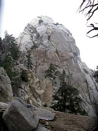
Everything you read about the many cut switchbacks is true, but it wasn’t too hard to keep to the trail up to the picnic tables by watching for white dots. It did take some work to find the trail again from the picnic tables. Other places we had some trail finding issues were around 4400 feet and around 7300 feet or so before we could clearly see the Potato. During such times, it was nice to have three people so one person could stay put and the other two could branch out looking for the correct route. We may have had some issues from the heavy rain the day before washing out areas where you might otherwise have seen the trail, but such incidents did not last very long. Here is the first view of the tram; it is visible if you look hard just to the left of where the white cloud intersects the mountain (although I never could get my brother to see it).
![View to Tram Top]()
As we were approaching the Potato clouds started coming in and we started to become concerned about the weather, especially after our experience the day before. At one point visibility became very limited, but then everything cleared up, and weather was never an issue again for us. Here is the limited visibility and the Potato:
![This is Desert Hiking in Summer?]()
![The Potato]()
The hike from the Museum to the tram is not as steep as the hike up big Iron Mt., but it is much longer, and you never really get the sustained steepness you do on Big Iron. It is the key portion of the hike. Once you get to the tram you can relax and get food from a cafeteria. If you go on, the next portion of the hike is the same mileage, but nowhere near the hike coming up. The hike after reaching the tram appears to be designed so that it can connect with all areas of interest in San Jacinto Park and be easy enough for tourists who come up the tram. It is an enjoyable hike, but nowhere near the challenge of coming up to the tram. It seems to me it would be possible to make a more direct trail to the summit in far less than half the distance. While the hike on top is quite nice, I can see why locals who like to hike C2C on a regular basis do not regularly complete this portion of the hike.
Now for some statistics. I drank 1 liter of Gatorade on the way to the Museum trailhead, 4 liters of Gatorade plus 2 liters of water on the way up to the tram, 1 liter of liquids (plus ice cream) at the tram cafeteria, and 1 liter of Gatorade plus 1.5 liters of water on the next leg. We started at the Museum trailhead at 2:20 am, made the picnic tables in 52 minutes, and reached the tram cafeteria at about 12:30. We hit the next trail at 2 pm, took a 15 minute restroom break on the way up (yes, the second trail is so touristized that it has an outhouse and a running water source, although it must be treated, a little over 2 miles in), hit the peak at about 5, stayed on the peak for about 30 minutes, and then made it back to the ranger station to turn in our permit at 7:45 pm.
When we got back down from the tram we were utterly amazed at how dry the air was; it was not anything like the night before. So we hiked C2C on a blue moon with a once upon a blue moon weather story to match. We all enjoyed the hike and thought we might do it again another time, circumstances permitting.


Comments
Post a Comment