
-
 23255 Hits
-
 90.81% Score
-
 33 Votes
|
|
Mountain/Rock |
|---|---|
|
|
37.77666°N / 107.69562°W |
|
|
San Juan County |
|
|
Hiking, Mountaineering, Skiing |
|
|
Spring, Summer, Fall, Winter |
|
|
13160 ft / 4011 m |
|
|
Overview
Grand Turk was recently erased from SP. I will try to replace the missing information as best as I can. It was a destination for SP Colorado summer gathering in 2008.Grand Turk is located in the vicinity of town Silverton. Silverton is only 3.0 miles from its summit (northeastern direction). The peak is usually bagged with other 13ers in the area: Sultan Mountain and Spencer Peak. In fact, the trail from Little Molas Lake TH goes just below the summit of Spencer Peak and you have to ascend only about 100-150 feet to claim Spencer's summit. Spencer Peak was just recently named after mathematician who was born and educated in Colorado. Sultan is located just less then a mile to the north of Grand Turk.
Based on the peakery data, it ranks as the 448th highest mountain in Colorado and the 646th highest in the USA.
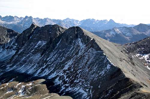 The three-pronged summit of Grand Turk puts you eye to eye with the state's densest cluster of peaks higher than 13,000 feet. Photo taken from the slopes of Sultan Mountain. The three-pronged summit of Grand Turk puts you eye to eye with the state's densest cluster of peaks higher than 13,000 feet. Photo taken from the slopes of Sultan Mountain. |
Little Molas Lake Trailhead is located on Colorado Trail, and Backpacker magazine listed Grand Turk among top 3 peaks easily accessible from Colorado Trail. The views from the summit of Grand Turk are immense in all directions. You can see Grenadier range, Needle Mountains, peaks above Silverton, Red Mountain, Ice Lake Basin peaks just to mention a few.
Grand Turk is popular with backcountry skiers in the winter. And Colorado Trail is popular with mountain bikers in the season.
 View into Ice Lake Basin - better when enlarged, many nice and popular 13ers in the area. View into Ice Lake Basin - better when enlarged, many nice and popular 13ers in the area. |
Getting There and hike information
Drive south from Silverton on US-550 approximately 6 miles to the Little Molas Lake turnoff (not Molas Lake). The turn off is well signed, and is 0.4 miles north of Molas Pass. Drive west 1 mile on a good dirt road (2 WD vehicles ok) to the lake and parking area.There is a gate at the turn off from US-550, which stays open till late November, pass this gate and drive 3/4 of a mile to the parking area by the lake. By the way, don't confuse Little Molas Lake with Molas Lake (much more commercial and right below the highway), a mile north on U.S. 550 (opposite site of road).
 Grand Turk and Sultan as seen from Silverton Grand Turk and Sultan as seen from Silverton |  Narrowing basin between two 12,000 foot peaks Narrowing basin between two 12,000 foot peaks |
Hike: Assuming that you are able to drive to the Little Molas Lake TH, the hike gains 3,600 feet in 7.7 miles round trip (the mileage includes bagging Spencer Peak and Sultan Mountain). Walking from the highway 550 (gate closure) to the Little Molas Lake TH parking adds 1.5 miles round trip and 200 feet of additional elevation gain.
The hike is mainly off-trail, but higher in the basin, when approaching the saddle between West Turkshead Peak (12,849 feet) and Turkshead Peak (12,734 feet) you will find a trail leading to Spencer Peak (you can by pass Spencer's summit on its western slopes), you have to descend into the saddle between Spencer and Grand Turk. Both Grand Turk and Sultan Mountain becomes visible once you reach the top Spencer Peak. The main trail leads to Sultan Mountain, Grand Turk is slightly to the west and there is no well defined trail. Choose the most comfortable way up its grassy southern slopes. You may need an ice ax early in the season when crossing snow slopes.
 Trail higher up in the basin Trail higher up in the basin |  Looking back to the Little Molas Lake Looking back to the Little Molas Lake |
Trailhead and Trail: You will first reach a small parking area (only a few cars, some signs) and little trail leading south to the Little Molas Lake (part of Colorado Trail), and if you continue driving on a good dirt road, you will make a loop around the campground area and come back. This road ends past the campground, and at the bend of the loop there is a large parking area with toilets.
I found a start of one trail at the camping site #1, and there is another start of the trail about 100 yards east from the main parking area (end of the loop, large parking, dry toilets). These two trails come together, but tend to disappear (at least I found myself off the trail). The route finding is not difficult. Head north and as soon as you get above the tree line head for the end at the high basin between the steep cliffs of peaks 12,849 feet and 12.734 feet. Colorado Mountain Book names them as West Turskhead Peak (12,849) and Turkshead Peak (12,734). You should be able to spot a trail at the eastern side, which leads nicely to the saddle. It may appear steep from the distance, but as you continue on the trail, the difficulty does not exceed class 2. There is a trail from the saddle leading towards Spencer Peak, which you will be able to see. As I mentioned above, Grand Turk and Sultan Mountain come to your view as soon as you get over Spencer.
 Spencer Peak as seen from the approach Spencer Peak as seen from the approach | 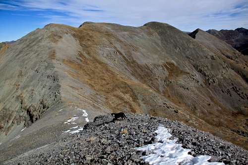 Grand Turk as seen from Spencer Grand Turk as seen from Spencer |
Red Tape
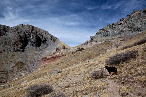
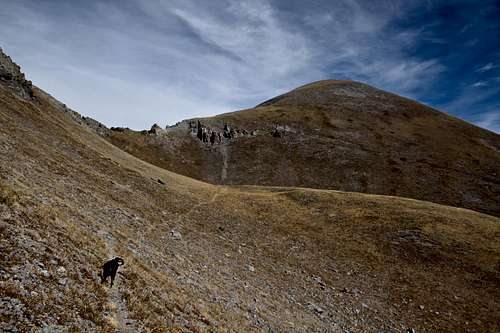
 Hike illustration
 Dog friendly hike
Little Molas Lake Trailhead is part of the Colorado Trail (from Denver to Durango).
It is a popular trailhead with mountain bikers and hikers in the summer, and back country skiers in the winter. Always check San Juan Avalanche conditions prior venturing there in the winter.
The parking is free.
Dog friendly hike, does not exceed class 2.
Camping
There is camping available right at the Little Molas Lake Campground accessible by 2WD vehicles. You can also backpack into a higher country and find many beautiful spots to spend a night.Molas Lake Campground is a well developed campground - about 2 miles drive from the TH. Supposedly rated as the most scenic campground in Colorado - views from there are indeed fantastic!.
Weather
Click for weather forecast