
-
 9092 Hits
-
 81.18% Score
-
 13 Votes
|
|
Mountain/Rock |
|---|---|
|
|
42.41046°N / 8.91161°E |
|
|
Download GPX » View Route on Map |
|
|
Hiking, Scrambling |
|
|
Summer, Fall |
|
|
7031 ft / 2143 m |
|
|
Overview
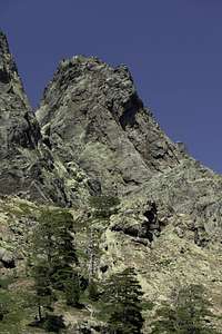
 A Muvrella seen from Punta Culaghia A Muvrella seen from Punta Culaghia |
The great Corsican trekking trail GR20 between Calenzana in the north and Conca in the south has its most difficult parts in its northern section. After three days (when starting in the north) you reach the former ski station Haut-Asco, from where the treck turns to Cirque de la Solitude, its most impressive and beautiful, but also most difficult stage. Before starting on the stage most of the trekkers take a rest at one of the few hotels / hostels in the village. However, a few years back the trekking trail didn't even touch Haut-Asco rather bypassing it by negotiating the ridge between A Muvrella and Punta Strancianone (or rather between the saddles Bocca di Stagnu and Brêche de Missoghiu. The trail is still there, fallen a bit into disrepair and certainly more difficult than it used to be. However, the whole traverse offers among the best views of Corsica's highest mountains, Monte Cinto, Capu Larghia and Punta Minuta. Thus its two highpoints Punta Culaghia and A Muvrella are among the most interesting, though relatively unknown mountains.
A Muvrella is located directly to the east of Bocca di Stagnu, the saddle through which GR20 runs. Almost none of the trekkers consider to climb the 200m to the top of the mountain, mostly since they have to prepare for a very steep and long descent to Haut-Asco. Thus mostly day tourers climb the mountain, starting at the former ski station, climbing GR20 to the saddle and from there follow apath up the west ridge of the mountain.
 |  |  |
However, the path vanishes after several swithbacks and you are left to your own devices to reach the summit. A couple we met on top told us about an easy route from the north-west but we followed the west ridge directly, a bit of exposed UIAA II+ climbing across the granite blocks along the ridge. Having left our hiking poles on the lower ridge we were forced to return the same way instead of exploring the reportedly easier route.
 |  | 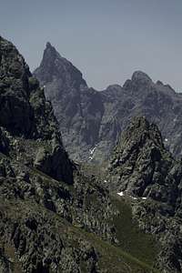 |  |
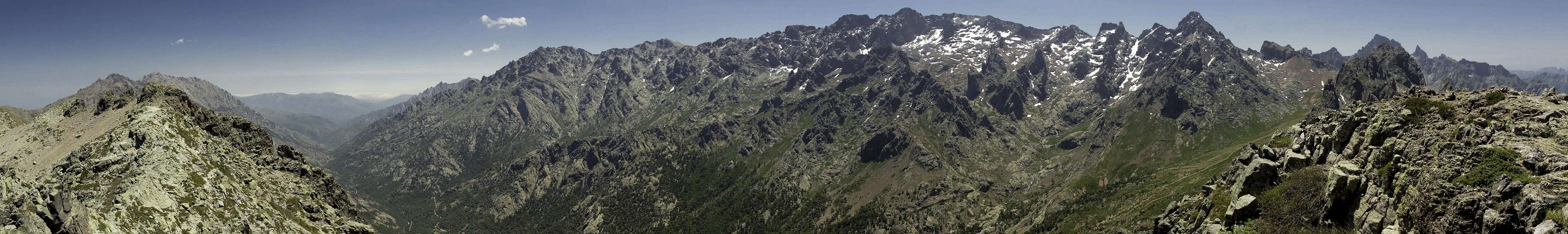
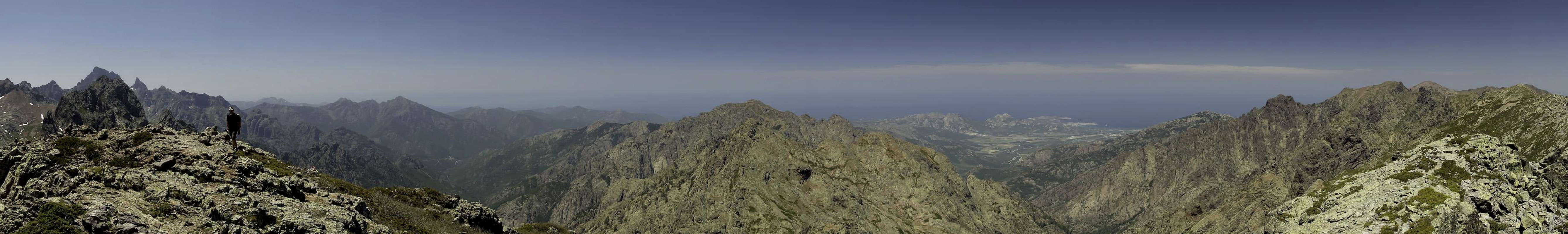
A Muvrella certainly can be called a perfect llookout: to the south you can view the barrier of the Monte Cinto Massif sretching all the way to Pagla Orba and Capu Tafonatu in the west. To the north there are the last 2000ers before the terrain quickly drops towards the sea, which is visible across the north-western city of Calvi.
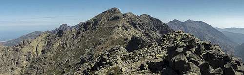
2 x 180° summit panorama
  |
 |
Getting There
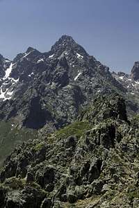
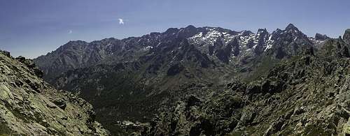 The Monte Cinto Massif as seen from Bocca di Stagnu
The closest village and trailhead is the former ski station of Haut-Asco
, right underneath A Muvrella. Since it is also one of the few places GR20-trekkers can get a hot shower and something to eat it is a veritable trekkers' base. Lots of tents, a hostel, two hotels and everywhere heavily laden people either preparing for or resting after the hardest of the trek's stages through Cirque de la Solitude.
- From the airport Bastia Poretta:
- Take N193 south, direction Corte
- At Ponte Leccia switch to 197 north, direction L'Ile Rousse.
- After a few km turn left onto D47, later D147, direction Asco and Haut-Asco.
- Take N193 south, direction Corte
- From the airport Ajaccio
- Take N193 north all the way across Col de Vizzavona and through Corte to Ponte Leccia
- Here switch to 197 north, direction L'Ile Rousse.
- After a few km turn left onto D47, later D147, direction Asco and Haut-Asco.
- Take N193 north all the way across Col de Vizzavona and through Corte to Ponte Leccia
Red Tape
 Papillo machaon
In 1971 the Parque Naturel de la Corse was established. It comprises 2500 square km, mainly in the centre of the island. A Muvrella is located within the park boundaries. Camping is not allowed in the park and apart from that the usual restrictions apply.
Accommodation
Accommodation has changed a lot during the last ten years. Today it is possible to book holiday homes, hotel rooms or apartments from any travel office. Also, there are a number of sites on the internet dedicated to Corsica accommodation. You can get apartments and holiday homes in any of the villages along the coasts.Since A Muvrella is located far away from almost all habitation there is only one possible overnight location (if you don't have a car) which is the former ski station of Haut-Asco. However, during the trekking season, you'll have trouble ggetting accommodation there. You might try Asco (still a good 10 km away) or a campground in Val d'Asco.
Weather Conditions
Maps & Books
Maps
- Corte / Monte Cinto
1 : 25.000
Carte de Randonnée 4250 OT
ISBN: 978-2114250038
Books
There are quite naturally quite a number of guidebooks, most of them in French. I found the following as good as could be expected:
- Corsica (Corse / Korsika)
Klaus Wolfsperger
Rother Verlag
ISBN: 978-3-7633-4819-0 (English)
ISBN: 978-3-7633-4907-4 (French)
ISBN: 978-3-7633-4280-8 (German)