
|
|
Route |
|---|---|
|
|
49.22096°N / 20.00370°E |
|
|
Hiking, Scrambling |
|
|
Summer, Fall |
|
|
Most of a day |
|
|
Class 4 |
|
|
comparable to via ferrata grade 2 (B) |
|
|
Overview
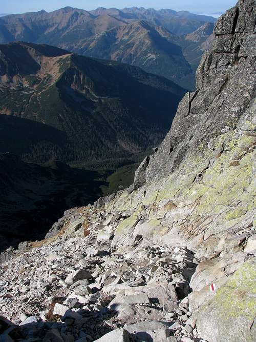
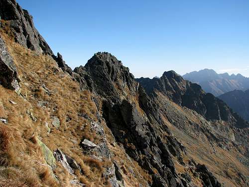
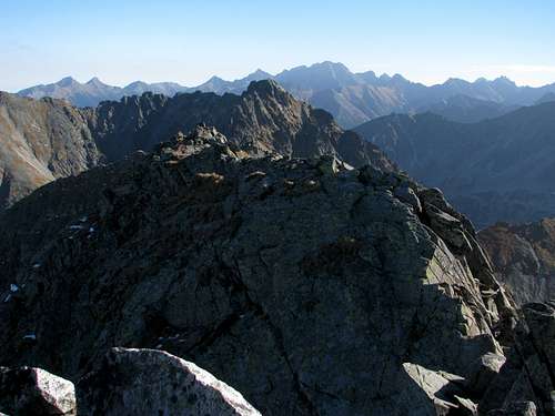
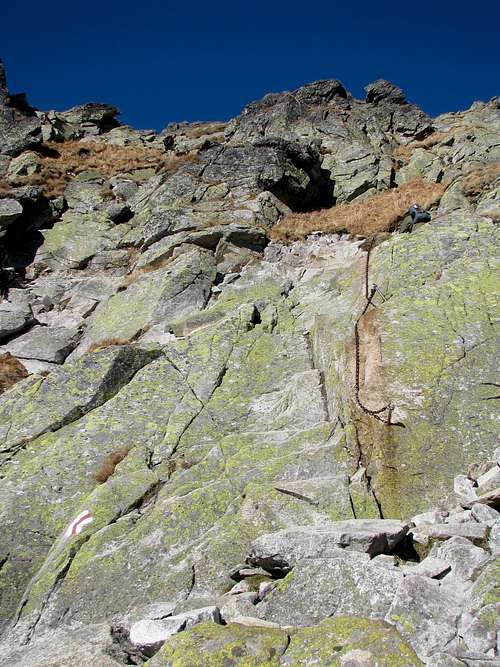
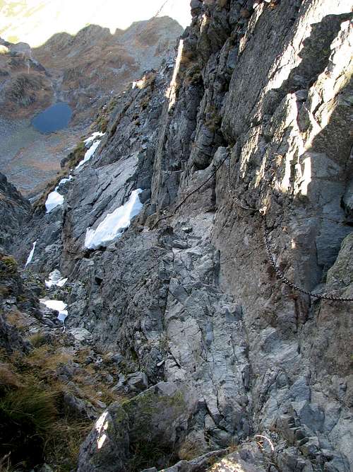
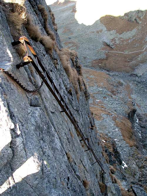
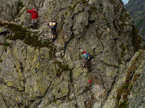
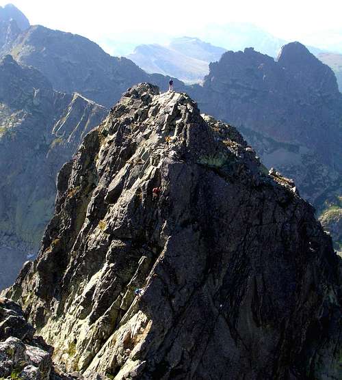
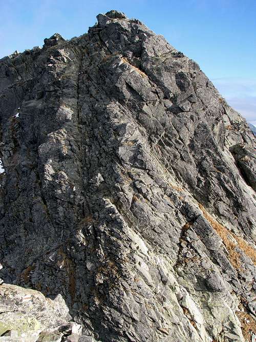
 The rockfall The rockfallDue to a sizable rockfall from Niebieska Turnia on 21 May 2018 (luckily there were no people on the trail then: Photos), the section of the trail between Świnica and Zawrat was closed for three years. Since 2021 you are only allowed to hike from Zawrat pass to Świnica, not in the opposite direction! Since 13 September 2023 the section between Zawrat and Kozia Przełęcz passes has been closed for repair work.The route described here is an attractive option for mountain hikers based in the town of Zakopane. It allows you to climb Świnica and Kozi Wierch at one go. Świnica at 2,302m dominates the panorama of the High Tatras seen from Zakopane. Kozi Wierch at 2,291m is the highest Tatra summit entirely within the confines of Poland. It rises east of Świnica and forms the east end of the most attractive, western section of the so-called Orla Perć (Eagle Path). The path, whose western section forms the second part of our route, is often called a via ferrata, which is misleading since - despite the metal chains, brackets and ladders as well as being comparable to an Austrian/German via ferrata grade 2 (B) - the Orla Perć is NOT a via-ferrata like those in the Alps. There is no cable to which you could clip yourself, which means that you are unprotected unless you clip yourself to the chains. This is possible and recommended by the national park authority but it is awkward and hardly anybody bothers to do so. The trail, waymarked with red stripes (against white background), is one-way between Zawrat Pass and Kozi Wierch. This part of our route is already briefly described on SP here. (If you come to think my page is in fact a duplicate page, please report it here.) The first part of our route (traverse of Świnica Massif), although apparently easier and a little less exposed than the second (Orla Perć), is not less deadly at all. For example, from June to September 2012 there were four fatal accidents there, while at the same time, as far as I know, two hikers perished on the second section. This may be partly explained by the fact that Świnica is more frequented than the Orla Perć. About two-thirds of all recorded accidents are triggered by slips on snow, ice (which may not be seen until you step on it) or just wet ground. 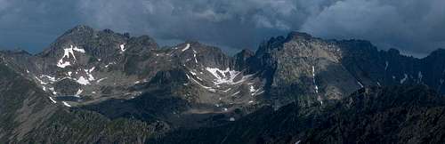
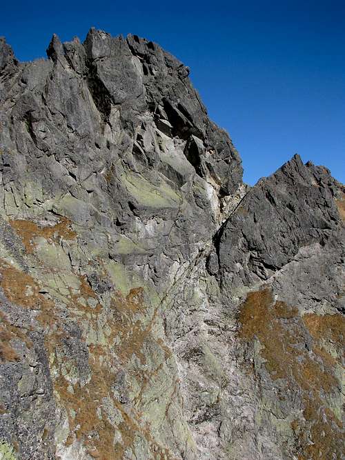
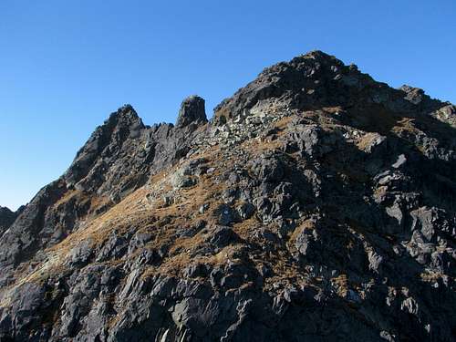
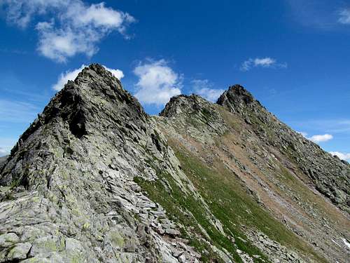
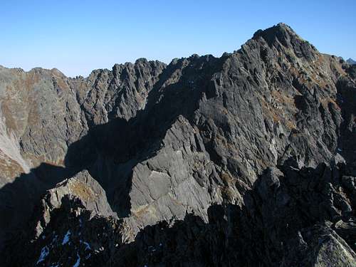
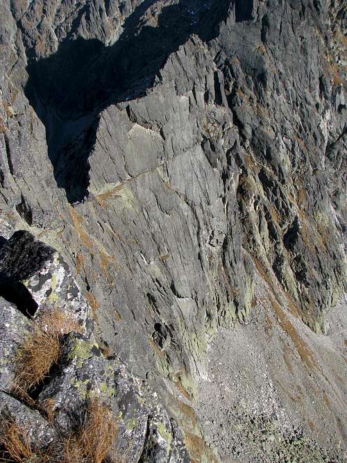
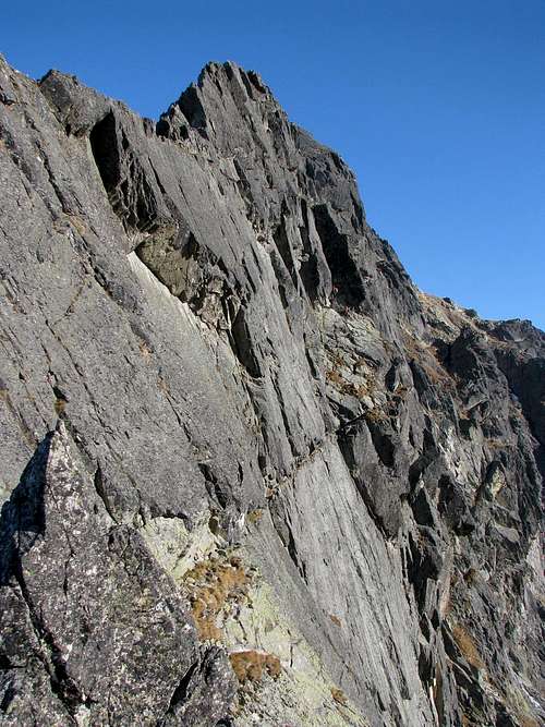
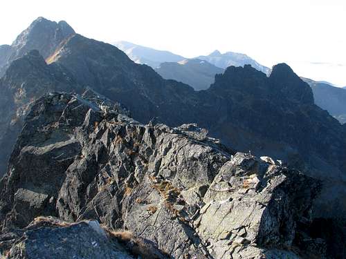
In this photo, Świnica rises on the left and Kozi Wierch is the highest peak to the right of the centre. Our path, whose parts you can try to spot in the photo if you enlarge it, traverses the south face of the Świnica Massif, descending from the main summit of Świnica, across the ribs of Gąsienicowa Turnia (the summit to the right of Świnica's main summit), to the snow patch under Niebieska Turnia (the next peak); then at the top of the talus the trail skirts the craggy slopes of Zawratowa Turnia to reach Zawrat Pass (well left of centre), which is the beginning of the Eagle Path. From then on the trail runs closer to the crest of the ridge, partly sticking to it, but often shunning its more difficult sections by traversing its northern flank.
|
Approach Routes
|
The "core route" begins at Świnicka (Świnica Pass, 2051m) on the main ridge of the Tatras, just west of Świnica. That will be three hours' walk along marked trails from the outskirts of Zakopane, i.e. from the place called Kuźnice, where there is the lower station of the cable car (aerial tramway). From the hut on Hala Gąsienicowa (Gąsienica's Pasture) it will take 1.5 hours to walk up to Świnicka Przełęcz. The quickest option - sensible only in the off-season, when there are no queues - is the cable car. A ride from Zakopane to the top of Kasprowy Wierch takes less than a quarter of an hour (you change cars halfway up, at the middle station), then it is about fifty minutes' walk - just about one hour altogether.
|


When To Climb & Essential Gear
 12 October 2008 12 October 2008 February FebruaryThis route is a hiking trail which makes sense when there is virtually no snow or ice on the ground and the rock is dry. That is why only "summer, fall" has been selected for the "season" row within the page profile at the top. The main problem with the summer is the crowds which come along with the school holidays. Weather permitting, September is better since it sees fewer people - just university students are still there. A weekday in October seems to be the best choice, however, it must be the right October and the right part of it, such as the week I spent in the Polish Tatras in the second half of October 2012 (all of my photos on this page were taken on 23rd Oct: sunny day, dry rock, no verglas, hardly any snow, hardly any people). In recent years, the Tatras have experienced very changeable weather conditions in September and autumn. Wintry spells alternate with summerish ones. If you decide to go in summer, an early start, say about 3 a.m., will let you avoid the crowds as well as a possible thunderstorm. An example of what often happens in summer is given here.
Hiking boots or approach shoes are a must. Gloves can be helpful (the chains can be cold or slippery). Consider a via ferrata set and a helmet.
In winter conditions, if there is plenty of snow and the chains, not to mention the paint marks, are buried under it (which is normal in winter and early spring, but can happen in autumn and occasionally in summer too), you would need the full range of mountaineering gear, lots of experience, a partner and avalanche awareness: Have a look at this video. If there is less snow, an ice-axe and crampons, and the skills of using them may suffice. |


Route Description
|
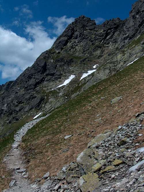
When you get to Świnicka Przełęcz (Świnica Pass) you will have your first goal - Świnica - close at hand, rising in front of you. From the pass, it is just 250m upwards to the top. You walk up, following the red stripes, along a well laid trail among blocks of granite. After a quarter-hour the trail turns right and starts a long traverse of the southern (right-hand in the photo below) side of Świnica. 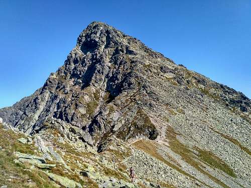
|
Descent
From Kozi Wierch you can descend south - following the black marks - to the hut in the Dolina Pięciu Stawów Polskich (Valley of the Five Polish Tarns) in an hour and a quarter. To get to Zakopane, you will have to follow the red marks of Orla Perć for about forty minutes. First go quite a bit down along with the black marks. (Careful at the start so that you will not follow the crest!) From where the red marks part with the black ones, an easy, peaceful traverse of the eastern side of the ridge will finally lead you back onto the crest just before a little col called Przełączka nad Buczynową Dolinką. Having crossed the crest you begin to downclimb Żleb Kulczyńskiego (Kulczyński's Couloir, YDS Class 3/4), in whose upper part you say goodbye to the red marks of Orla Perć and continue down the couloir via black marks, often "abseiling" by means of chains. From the bottom of the couloir a walk to the hut on Hala Gąsienicowa, past two beautiful tarns, takes five quarters of an hour, from there to Kuźnice (Zakopane) another five quarters of an hour.
|


Red Tape
Wandering off the waymarked trail and bivouacking are forbidden. The second part of the route is one-way.
Maps
A 1:25,000 map of the Polish and Slovak Tatras, such as this one by WiT, is good enough while a 1:50,000 is NOT. Usually several versions are available at the bookshops, souvenir shops and street stands in Zakopane. There is a special, 1:5,000 map of the Eagle Path and Świnica Massif by Sygnatura. Another map at a scale of 1:5,000 has been published by WiT. It is less detailed, but made of plastic and has a 1:30,000 map of the Polish Tatras on its back.
Mountain Conditions
 23 October 2012
- Current weather conditions and live webcam views
- Forecast for Kasprowy Wierch
- Forecast for Zakopane
- Avalanches?
- Conditions on the trails in Polish
- Mountain rescue team's phone number: (+48) 601 100 300
Accommodation
 'Murowaniec' Hut