This PAGE is DEDICATED in MEMENTO of MARCO COSSARD (* Aosta June 23th, 1949 - † Aosta Jenuary 16th, 2013). Questa PAGINA é DEDICATA alla MEMORIA di MARCO COSSARD (* Aosta 23 Giugno 1949 - † Aosta 16 Gennaio 2013).
Marco Cossard
Overview
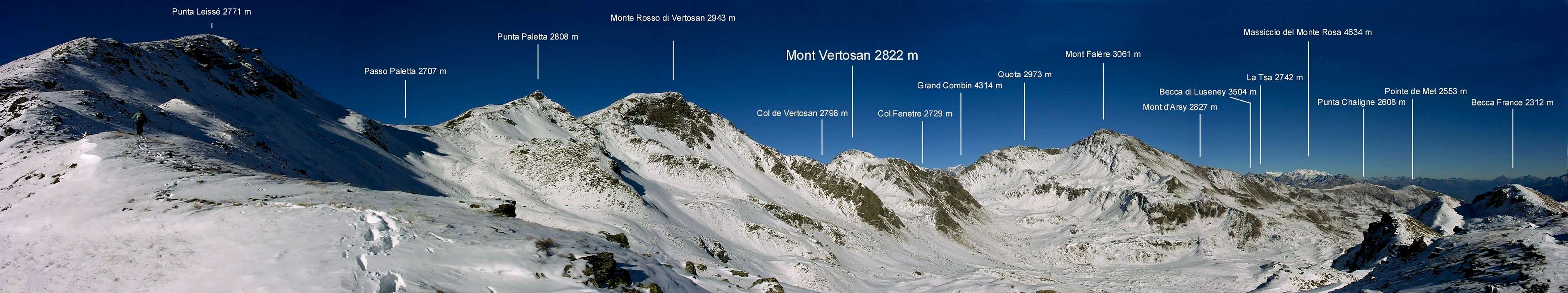
Enough elevated mountain (2.821 meters or 2.822 meters according to I.G.M.) that however curtains to disappear, since subjugated by the most imposing masses of the Mont Fallère (3.061m) and of the Red Mountain or Mont Rouge de Vertosan (2.943m) on the crest watershed between the Central Valley of Dora Baltea Stream and that of Great Saint Bernard, that gathers all and three the tops among the tall Walloon of Verrogne in the Basin of Vetan, the Comba of Meana or secondary Meanaz to the "Vallone" of Vertosan and the Comba de Flassin to Northern Slope, above the Communes of Saint Oyen and Etroubles, in the Valley of the same Gran St. Bernard. The Military Geographical Institute in its Paper to 25.000 attributes this toponym to a grassy-rocky Quota 2.793 meters more in southwest above the Hill of Vertosan Sud (2.768m), but the attribution results to be wrong, since our mountain is slightly situated more to Northeast of the same one, of which is also besides more elevated even if of not very, overhanging the same one the Fenetre Pass (2.728m), before the crest of border raises again him to the Quota 2.971 meters or Great Shoulder Northwestern of the Fallère, more elevated peak of the whole small, but well wide, Subgroup. Top, of very easy slope, predominantly frequented ab immemorabilis from the hunters, as from the numerous ones "trenches" and "fortifications" on and near the peak; rarely frequented by the ski-mountain climber, that prefer the more neighbors and important Monte Rosso and Mont Fallère, or the always easy and neighbor Leissé and Aouilletta Points, and still less, for the same motive, from the excursionists. Beautiful views on the walloons above quoted, on the pyramids of the Grand Rochère and the Grand Golliaz respectively to West and Northwestern, on the neighbor Mont Fallère to East, as well as in distance on the alpine entourage that reaches the Mont Velan and the Combins from the Grandes Jorasses.
Montagna abbastanza elevata (2.821 metri o 2.822 come da I.G.M.) tendente a disparire, poiché soggiogata dalle ben più evidenti ed imponenti masse del Mont Fallère (3.061 m), nonché dal Monte Rosso o Mont Rouge de Vertosan (2.943 m) sulla cresta spartiacque tra la Valle della Dora Baltea e quella del Gran San Bernardo, riunente le tre cime ed i tre Valloni di Verrogne laterale alla Conca di Vétan, la Comba Meana o Meanaz secondaria del Vallone di Vertosan e la Comba de Flassin sul versante Settentrionale, al di sopra dei Comuni di Saint Oyen ed Etroubles, all'ingresso della parte principale della Valle dello stesso Gran San Bernardo. L'I.G.M. nella sua Carta al 25.000 attribuisce codesto toponimo all'erboso-rocciosa Quota 2.793 metri ma leggermente più a Sudovest appena sopra il Col de Vertosan Sud (2.768 m), senonché tal attribuzione risulta sia inadatta che erronea, dacché la nostra montagna é sita maggiormente a Nordest risultando, anche se di non molto, più elevata ed inoltre soprastante il Col Fenetre (2.728 m), prima che la cresta divisoria raggiunga la Quota 2.971 metri o Spallone Nordoccidentale del Fallère, vetta maggiormente elevata del piccolo ma ben esteso omonimo Sottogruppo. Sommità, di men che facile salita, predominantemente frequentata ab immemorabilis dai cacciatori, come palesemente notasi dalle numerose "trincee" e "fortificazioni" di vetta e dintorni; raramente frequentata dallo sci-alpinismo, preferente i più importanti nonché viciniori Monte Rosso e Mont Fallère, oppure le pur sempre facili e viciniori Punta Leissé e Aouilletta, per le stesse motivazioni, similarmente dagli escursionisti. Belle vedute sovrastanti i valloni sopra citati, sulle piramidi della Grand Rochère e del Grand Golliaz rispettivamente ad Occidente ed a Nordovest, sul vicinissimo Mont Fallère ad Oriente, mentre in distanza la vista spazia sulla Catena del Monte Bianco principalmente dalle Grandes Jorasses ed insino alle Alpi Pennine sul Mont Velan ed il Gruppo dei varii Combins.
First Ascents
First on the summit: Unknown.
In winter: Unknown.
Great Traverse Testa Cordella-Mont Flassin NW Top-Flassin's Hill-Quota 2.758/9m-Mont Flassin SE Summit-Northern Vertosan's Pass-Mont Vertosan-Fenetre Hill, with descent to Comba Flassin: Osvaldo Cardellina, Marco Cossard and Giuseppe Lamazzi; Sep 17th, 1972.
OLD TRAVERSE on ANCIENT VERTOSAN
Getting There
BY CAR:
From Torino, Milano, etc: Motorway A5. Exit at Aosta Ovest.
From Switzerland: through the Grand Saint Bernard Tunnel or the namesake pass.
From France: through the Mont Blanc Tunnel or Petit Saint Bernard Pass: It is not necessary to take Motorway A5: you can drive on SS.26, in the direction of Aosta.
BY PLANE:
Aeroporto "Corrado Gex" Saint Christophe (Aosta).
From the Aosta Ovest (Aymavilles) exit of the motorway, take state highway n° 26 Toward Courmayeur. After about 5 km, you'll reach the Village of Saint Pierre (731m). Turn right on the road for the small Village of Saint Nicolas (1.200m). Past the village, you'll reach a fork. The left branch leads to Colle di Joux (1.898m). Take instead the right branch in the direction of Vetan (1.671m). At the center of the small village turn left and proceed for about 150m on paved road.
Approaches
From Vétan-Dessus (= than Above; 1.737m), sets in the homonym pleasant Basin understood between the Southern slopes of the Aouillette or Oilletta (2.616m) and of the Point Leissé or Leysser (2.771m), to go up on the dirt road "poderale" up to his term, as soon as over a hotel; to continue toward West with a road of link-path n° 17 that, first getting further itself and then reapproaching itself to the Torrent de Vétan, it is addressed toward the Alpe Chatalanez (1.857m). From this to continue to North reaching, shortly time, an alternative on the excavated road; leaving on the left the ramification that, with a turn very more breadth toward West and passing through the Pastures of Pesse Dèsot (1.975m) and Tramail the Or (= Tall Alp, generally not the most elevated but Middle for the move of the livestock; 2.043m), that it reaches the important "Alpe" of Grandes Arpilles however (2.133m), to reach this last with the ramification of right. At first the same reaches the alternative 1.909 meters and then, leaving the ramification to Northeast for the Alp Thoules (1.944m), continuous to North-northwest reaching the alternative 2.091 meters, on the dirt road poderale that originates from the Tramail the Or; turning more to Northeast, in little time, the Alpage of Grandes Arpilles is reached with rising. From the alternative 2.133 meters, as soon as above, he abandons on the left or West the branch addressed to the Alps Pesse Damon (2.274m) and Tsacreuse or Tsecreousa (2.398m), where this ramification finishes to the slopes of the Point Aouilletta; instead to continue with direction opposite East-northeast, and passing some small secondary small streams, to reach a fountain on the margin of the road to quota 2.206 meters. Here the same one changes completely direction toward North entering the small narrow Walloon of Verrogne, above the inhabited homonym (1.595m), always in the Commune of Saint Pierre. To continue in the same direction through slopes steep rich in flora along the Oriental side of the Point Leissé and, gone beyond the quota 2.279 meters impending the Alp Verdjouan (2.101m), to reach the most Western branch of the Torrent de Verrogne, to quota 2.284 meters; to flank it for brief line for then to ford it to quota 2.300 meters, where the path begins n° 13 for the Hill of Paletta (= Shovel) and immediately after a taking of the water. To always continue instead on the road "poderale" that, after having formed a brief handle to quota 2.329 meters, as soon as under a series of four minuscule lakes, it brings him to North and, leaving on the right a small loch but of greater dimensions to quota 2.377 meters, reach immediately after the ancient Alp of Les Crottes (2.385m; characteristic stalls with vaults to form of arc), where it also finishes the road. From the hairpin bend 2.329 meters it is possible besides to continue on a small path unnumbered, that continues in parallel way to the dirt road, immediately West bottom.
Da Vétan-Dessus (= di Sopra; 1.737 m), posto nell'omonima amena Conca rappresa tra i versanti Meridionali dell'Aouillette o Oilletta (2.616 m) e della Punta Leissé o Leysser (2.771 m), continuare sulla strada poderale insino al suo termine, appena oltre un albergo; proseguire verso Ovest con una strada di raccordo-sentiero n° 17 che, prima allontanandosi e poi riavvicinandosi al Torrent de Vétan, s'indirizza verso l'Alpe Chatalanez (1.857 m). Da questa continuare verso Settentrione raggiungendo in breve tempo un bivio sulla strada sterrata; lasciando sulla sinistra la ramificazione che, tramite un giro molto più largo verso Ovest e passando attraverso gli Alpeggi di Pesse Dèsot (1.975 m) e Tramail l'Or (= Alto Alpeggio, in genere non il più elevato ma di Mezzo per lo spostamento del bestiame; 2.043 m), che raggiunge comunque l'importante Alpe di Grandes Arpilles (2.133 m), arrivare a quest'ultima con la ramificazione di destra. La stessa dapprima tocca il bivio 1.909 metri e poi, lasciando a Nordest la ramificazione per l'Alpe Thoules (1.944 m), continua a Nord-nordovest raggiungendo il bivio 2.091 metri sulla strada poderale che proviene dal Tramail l'Or; volgendo più a Nordest in poco tempo si raggiunge l'Alpe di Grandes Arpilles con sorgente. Dal bivio 2.133 m, appena sopra, si abbandona sulla sinistra od Ovest il ramo indirizzato alle Alpi Pesse Damon (2.274 m) e Tsacreuse o Tsecreousa (2.398 m), ove termina questa ramificazione alle pendici della Punta Aouilletta; invece continuare con direzione opposta Est-nordest e, sorpassando alcuni torrentelli secondari, raggiungere un fontanile sul ciglio della strada a quota 2.206 metri. Qui la medesima volge completamente direzione verso Nord entrando nel piccolo e stretto Vallone di Verrogne al di sopra dell'omonimo abitato (1.595 m), sempre nel Comune di Saint Pierre. Perseverare nella stessa direzione, attraverso versanti scoscesi ricchi di flora, lungo il fianco Orientale della Punta Leissé ed, oltrepassata la quota 2.279 metri soprastante l'Alpe Verdjouan (2.101 m), raggiungere il ramo più Occidentale del Torrent de Verrogne, a quota 2.284 metri; fiancheggiarlo per breve tratto per indi guadarlo a quota 2.300 metri, ove inizia il sentiero n° 13 per il Colle di Paletta e, subito dopo, una presa dell'acqua. Procedere invece sempre sulla strada poderale che, dopo aver formato una breve ansa a quota 2.329 metri, appena sotto una serie di quattro minuscoli laghetti, si riporta a Settentrione e, lasciando sulla destra un piccolo lago, ma di dimensioni maggiori, a quota 2.377 metri, perviene subito dopo all'antica Alpe di Les Crottes (2.385 m; stalle caratteristiche con volte a forma di arco), dove termina anche la strada. Dal tornante 2.329 metri è possibile inoltre proseguire su di un sentierucolo senza numerazione, che prosegue in modo parallelo alla strada, subito sotto ad Ovest.
Route
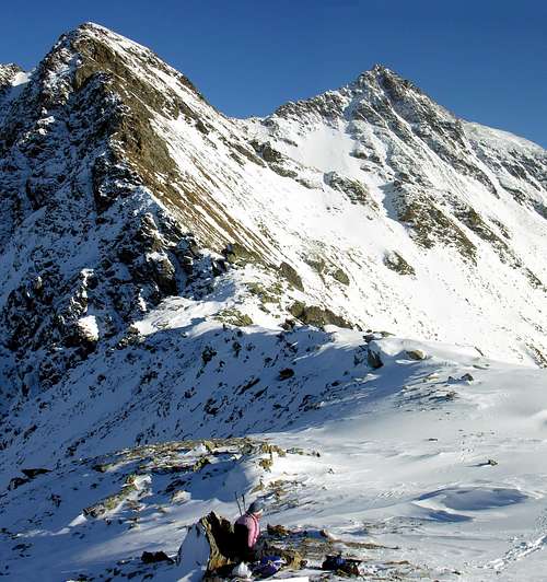
From the Alp Les Crottes (good point of departure, if he owns the permission with authorization to proceed with auto along thedirt road "poderale") to climb with the path n°13 along a secondary branch of the Torrent de Verrogne and, fording twice the same, to climb with run, to form of sinusoid, reaching the quota 2.601 meters; immediately after the same one the path is rejoined with another not numbered that, always departing from the Alpages Les Crottes but with run mostly in East, it flanks four small underlying lakes the more main point Lac Mort (2.634m). You reaches, in bottom, so the small basin the Fenetre Pass to quota 2.610 meters in a stony ground formed by rocky blocks and deposits, where in beginning in summer it is possible to still find some small snowfield. With a brief diagonal from right toward left easily the hill is reached (2.728/9m; 0h'50 from the Alpages Les Crottes). From this to go up again, through a slender and discontinuous trace of path, the easy Crest East-northeast with run among scattered rocky deposits and fine debris-rubbles at first toward West and then more to Southwest, meeting different "ambushes" of hunting, especially in the near of the Summit (0h'20 from the hill; 2h'00/2h'15 in total from Vétan Village-Resort).
Dall'Alpe Les Crottes (ottimo punto di partenza, se si é in possesso del permesso con autorizzazione a procedere con automobile lungo la strada poderale) salire con il sentiero n°13 lungo un ramo secondario del Torrent de Verrogne e, guadando due volte lo stesso, salire, con percorso a forma di sinusoide, raggiungendo la quota 2.601 metri; subito appresso la medesima il sentiero si ricongiunge con un altro non numerato che, sempre partendo dall'Alpe Les Crottes ma con percorso maggiormente ad Oriente, fiancheggia quattro laghetti sottostanti il più importante Lac Mort (2.634 m). Si raggiunge così la piccola conca al di sotto del Col Fenetre a quota 2.610 metri in una pietraia formata da blocchi rocciosi e detriti, dove in inizio di estate è possibile trovare ancora qualche piccolo nevaio. Con un breve diagonale da destra verso sinistra, facilmente, si raggiunge il colle (2.728/9 m; 0h'50 dall'Alpe Les Crottes). Da questo risalire, tramite una esile e discontinua traccia di sentiero, la facile Cresta Est-nordest con percorso tra fini detriti rocciosi e blocchi sparsi dapprima verso Ovest e poi più verso Sudovest, incontrando diversi appostamenti di caccia, soprattutto nei pressi della Sommità (0h'20 dal colle; 2h'00/2h'15 in totale dal Villaggio Turistico di Vétan).
Difficulties
This route can be considered F.
L'itinerario è classificato F.
Equipment
Normal hiking gear.
Da escursionismo.
Campings
Remember that free camping is forbidden (except for emergency reasons, over 2.500m, from darkness until dawn).
Mountain Condition
Meteo: you can find all the needed informations at the official site of the Valle d'Aosta Region:
"Guida dei Monti d'Italia-Alpi Pennine" (Vol.I°) di Gino Buscaini-Club Alpino Italiano/Turing Club Italiano, Luglio 1971 (in Italian).
"80 itinerari di Escursionismo Alpinismo e Sci Alpinismo in Valle d'Aosta", di Osvaldo Cardellina, Ed. Musumeci, Giugno 1977 (in Italian); seconda Ed. Luglio 1981; terza Ed. Luglio 1984; (in French), prima Ed. Febbraio 1978; seconda Ed. Marzo 1980.
"Diari Alpinistici" di Osvaldo Cardellina e Indice Generale accompagnato da Schedario Relazioni Ascensioni 1964-2019 (inediti).
MAPS:
Kompass "Monte Bianco Valle d'Aosta Sentieri e Rifugi" Carta turistica 1:50.000.
Ediz. Bottega D'Arte Alpina Coumayeur "Carta Turistica della Valle d'Aosta" di Alessio Nebbia 1:100.000.
Parents refers to a larger category under which an object falls. For example, theAconcagua mountain page has the 'Aconcagua Group' and the 'Seven Summits' asparents and is a parent itself to many routes, photos, and Trip Reports.

 7149 Hits
 87.31% Score
 24 Votes