
-
 5920 Hits
-
 79.44% Score
-
 11 Votes
|
|
Mountain/Rock |
|---|---|
|
|
48.40325°N / 18.87720°E |
|
|
Hiking |
|
|
Spring, Summer, Fall, Winter |
|
|
3310 ft / 1009 m |
|
|
Topographic isolation: 28 km
Nearest higher peak: Priečne (1023 m)
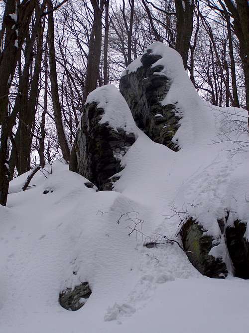
Prominence: approximately 580 m![Andezite rock]()
Andezite rock![On the summit]()
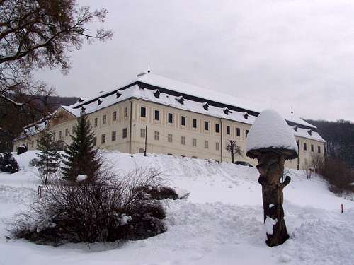
On the summit![Manor house in Svaty Anton/Szentantal]()
The manor house of the Koháry family![Stylish informing]()
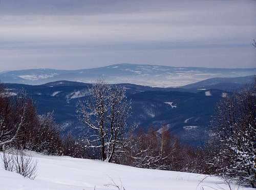
Stylish informing![View of Javorie/Jávoros]()
The surrounding of Sitno/Szitnya
Nearest higher peak: Priečne (1023 m)
Prominence: approximately 580 m
Overview
Andezite rock
Slovakian name: Sitno
Hungarian name: Szitnya. But earlier it was also called Attila-hegy (Attila’s hill)
German name: Szithna-Berg or Berg Sitno
In the following text I give both the Slovak and the Hungarian versions of the geographical names.
This mountain – despite of its moderate height – is an important highpoint:
- Highpoint of the mountain range called Štiavnické vrchy/Selmeci-hegység. This mountain range is the largest volcanic mountain range of the Western Carpathians
- Highpoint of the historic County Hont of the Kingdom of Hungary. The territory of this county was changing during the history, so this highpoint status is true for the 11th-12th century and for the period 1802-1920. In 1920 the county was divided between Czechoslovakia and Hungary. In Czechoslovakia, the northern part of the county continued to exist until 1923, and so Sitno/Szitnya remained the county highpoint, too, until 1923
- The southernmost mountain of Slovakia exceeding 1000 meter
- One of the mountains that are the nearest to Budapest and exceeding 1000 meter:
o Kékes (1015 m), 81 km distance
o Sitno/Szitnya (1009 m), 102 km distance
o Javorie/Jávoros (1044 m), 106 km distance
The mountain gives a very impressive view, especially from south, from the village called Prenčov/Berencsfalu. This village is in 300 meter altitude, and the top of the mountain is towering by 700 meter above it.
Sitno/Szitnya is a volcanic mountain. Mainly covered with mixed forests – the most common trees are oak, beech and spruce, but there are many other species, too. The flora of the mountain is very rich, and so it was declared a nature protected area.
The top of the mountain is grassy, and near the summit there are also many rocky outcrops made of andesite.
On the peak
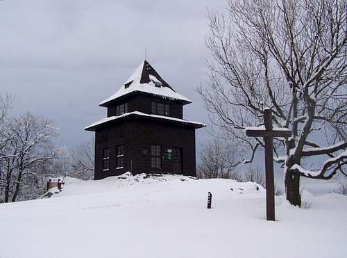
On the summit
The top of the mountain is grassy, and near the summit there are also many rocky outcrops made of andesite. These rocks serve as good lookout points. What can you see from here?
- Northwest: Vtáčnik/Madaras (1346 m)
- North: Kremnické vrchy/Körmöci-hegység (1317 m)
- Northeast: Low Tatras (2046 m)
- East: Javorie/Jávoros (1044 m)
- Southeast: Mátra (1015 m) in Hungary
- South: Börzsöny (938 m) in Hungary
Archeological traces of the a settlement have been found on the summit. Lusatian culture existed in the later Bronze Age and early Iron Age (1300 BCE – 500 BCE).
The ruins of the medieval Castle Szitnya can be found 900 meter far from the summit.
In 1727 Count Miklós Koháry made the first lookout tower of Hungary built on the summit. This construction collapsed in 1852, but in 1883 Prince Fülöp Coburg built a second building here. Now it serves with mixed functionality: as a seasonally opened tourist hut/snack bar/exhibition hall.
Besides this old tourist pavilion there is a bigger but abandoned tourist hut there, as well as an operating radio transmission station.
The summit has also a summit cross for the memory of Andrej Kmeť, the famous botanist, ethnographer, archaeologist, and geologist.
History
The manor house of the Koháry family
This mountain and its direct neighborhood had huge importance in the history of Hungary. The 3 most interesting historical places are the following:
Castle ruin Sitno/Szitnya
The ruin of the castle can be found east to the highest summit of the mountain, 900 meter far from it. The castle has two parts: a lower castle and an upper castle, in elevation of 850 meter, on andesite rocks towering above the forest around. The main “blue” marked tourist path doesn’t lead to the ruins: it is going by in a distance of 150 meter far from it. The direct access to the ruins is a side-path of this trail, marked by “green rectangle”.
The castle was built in the 13th century. It gained importance in the 16th century when Count Menyhért Balassa used this castle as his “headquarters” and raided the nearby rich mining towns. Finally the castle was besieged by 300 Spanish mercenaries in 1549. Count Menyhért Balassa lost this fortress and escaped to Transylvania. Later the castle became part of the holdings of the Koháry family. At the beginning of the 18th century the castle was destroyed, and now only its ruins can be visited.
Banska Štiavnica/Selmecbánya
Banska Štiavnica/Selmecbánya is the main attraction at Sitno/Szitnya. It is an old and famous historical mining town, only 6 km far from the summit of Sitno/Szitnya. The city gained the privileges of royal free city of Hungary already in 1238. The mountains made the city rich and important. The volcanic rocks of the mountains around were very rich in gold and silver ore. In 1627, gunpowder was used here for the first time in the world in a mine. Mining activity was so intensive that the population of the city itself exceeded 23000 according to the census of 1782, and it reached the population of 40000 together with its suburbs. It means that Selmecbánya was the 3rd biggest town of the Hungarian Kingdom at this time. The town was protected against potential Turkish raids with 2 fortresses that were built in the 16th century. These fortresses still exist in their original format.
In 1735, the first mining school in the Kingdom of Hungary was founded here. In 1763 the school was transformed into the Academy of Mining. It was the first mining academy in the world. In 1807 a Forestry Institute was established, and in 1848 the school was renamed the Academy of Mining and Forestry, the first technical university in the world. The city was a lively multicultural place. According to the last census (1910) before WWI, 55% of its population was Slovak, 42% of its population was Hungarian, and 3% of its population was German.
In 1919, after the creation of Czechoslovakia, the Academy was moved to Sopron in Hungary. The city lost importance. Once it had a population of 40000 – and now only 10000. The lack of development has also its advantage: because of its historical value, the town and its surroundings were proclaimed by the UNESCO to be a World Heritage Site.
Hikers can reach Sitno/Szitnya from Banska Štiavnica/Selmecbánya in the most easy way on the “red” marked tourist path to Saddle Krizna, and from there on the “blue” marked tourist path to the summit.
Svätý Anton/Szentantal
Now Svätý Anton/Szentantal is a village, in a valley 5 km east from Sitno/Szitnya. The village existed already in the 13th century, and it was owned by the ancient Hont-Pázmány clan. It had the privileges of market towns in the 16th-19th centuries. There was a castle on a hill above the town. The soldiers of this castle participated in the Turkish wars in the 16th-17th century. The town was also fortified in these times due to the threat of the nearby Turkish Empire of this era. It was also place for holding county meetings of Hont County.
In this time the town was owned by the potent Hungarian noble families of Pállfy and Illésházy. But the Koháry family made the town really famous. The family itself is perhaps the most ancient family of Hungary, dating back to the 10th century. In 1744 Count András Koháry built the new residence of the family on the place of the old castle. The huge baroque-classical style new manor-house has 4 gates, 12 chimneys, 52 rooms and 365 windows, symbolizing the numbers of the calendar. Last resident of the luxurious manor house was Tsar Ferdinand I of the Bulgarians. Don’t surprise: he was a grandson of Antónia Koháry.
Hikers can reach Sitno/Szitnya from Svätý Anton/Szentantal on the “green” marked tourist path to place called Vlčia jama, and from there on the “blue” marked tourist path to the summit.
How to get there
Banska Štiavnica/Selmecbánya is the nearest town to the mountain. This town can be quickly reached from the neighbouring major cities. Some examples:
- Budapest: 143 km distance. Take the European transit route E77 to Hontianske Nemce/Hontnémeti. From there it’s only a half hour’s drive on route 51
- Bratislava/Pozsony: 172 km distance. Take R1 speedway to Žarnovica/Zsarnóca. From there only 30 minutes to Banska Štiavnica/Selmecbánya
- Cracow: 257 km distance. Take the European transit route E77 to Kováčová/Kovácsfalva. From there further 9 km on R1 speedway to Hronská Breznica/Garamberzence. From there it’s only 20 minutes’ drive to Banska Štiavnica/Selmecbánya on route 51
Routes
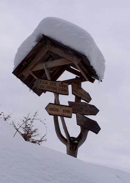
Stylish informing
The surrounding of Sitno/Szitnya
There are many marked and unmarked routes. These are the best options:
- From Prenčov/Berencsfalu. “Blue” marked trail. Distance to the summit: 8 km. Elevation gain: 710 m
- From Svätý Anton/Szentantal. “Green” and “blue” marked trails. Distance to the summit: 7.5 km. Cumulated elevation gain: 640 m
- From Ilija/Illés. “Green” and “blue” marked trails. Distance to the summit: 4 km. Cumulated elevation gain: 525 m
- From Počuvadlianske jazero/Bacsófalvi-tó. There are two routes. Both are a combination of “yellow” and “blue” marked trails. Distance to the summit: 4 km. Elevation gain: 330 m
- From Banska Štiavnica/Selmecbánya. “Red” and “blue” marked trail. Distance to the summit: 8.5 km. Cumulated elevation gain: 600 m
Camping and other accomodations
Auto-camp Počúvadlo (680 m)
At the lake called Počuvadlianske jazero/Bacsófalvi-tó you can find other cheap accomodiation, too.