The page was successfully edited.

|
|
Mountain/Rock |
|---|---|
|
|
37.76749°N / 121.70321°W |
|
|
Alameda |
|
|
1702 ft / 519 m |
|
|
Overview
Brushy Peak is the scenic highpoint of the small but enjoyable Brushy Peak Regional Preserve located just a short distance northeast of Livermore. Though the park is only 1,833 acres and the summit is less than 3.5 miles from the nearest interstate the location is an excellent place to get away from the nearby suburban surroundings. Park formation began in 1994 when the Livermore Area Recreation and Park District purchased the 507 acre summit area and then expanded following a 1997 agreement with the East Bay Regional Park District who manages the bulk of the park today. Though the summit itself is off limits except to guided tours (see Red Tape for alternatives below) a visit offers a quick escape to a variety of small wildlife, large domesticated animals (cows), and a reasonably close view of some of the 4,930 windmills that dot the Altamont Pass area.Brushy Peak likely derives its name from the scattered stands of coast live oak and California buckeye that cover the highest elevations in the park. Colorful lichens also cover sandstone rock formations these higher elevations. The vast majority of the area is dominated by California annual grassland and its lush green colors in the wet season and dry, brown conditions throughout most of the year. Two animal species dominate the area and can’t be missed… domesticated cows typically roam the slopes in all directions and ground squirrels dart in and out of seemingly millions of burrows scattered all over the hillside. Other species who have taken over otherwise abandoned burrows are also visible, and the park includes various amphibians in the alkali seasonal wetlands and ranch ponds within its boundaries. Several species of birds, reptiles, insects, and small mammals can be spotted as they interact in the open grasslands or more wooded areas of the park.

Getting There
 Brushy Peak Loop
 Cattle near the Trail
The route to Brushy Peak begins at the Laughlin Ranch Staging Area in Brushy Peak Regional Preserve. The entrance is well situated just off Interstate 580 in Livermore and is very easy to get to.
Brushy Peak Regional Preserve (37.74690° N, 121.70963° W)
Take the Vasco Road exit north from Interstate 580 in Livermore. Turn right just north of the interstate onto Northfront Road and follow it 0.8 miles to a stop sign. At the stop sign turn left and follow Laughlin Road 2.3 miles to the park at the end of the road. There is ample parking at the staging area, or just outside the park on the side of the road if visiting outside normal hours.
Bring your own drinking water... there is none at the trailhead!
Route
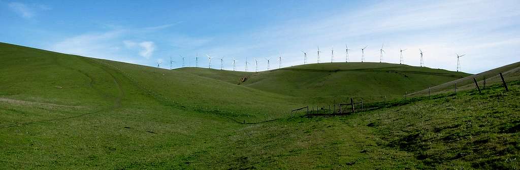
 Windmills in the Altamont Hills
Trip statistics from the Laughlin Ranch Staging Area:
2.7 miles one-way, 1100 feet elevation gain out with negligible gain on the return
The route to Brushy Peak isn’t very complicated and there are several trails and old fire/ranch roads that provide access both to the east and west of the trailhead area. All options are scenic and a nice loop can be completed. It is also worth extending the short loop by using the Laughlin Ranch Loop and Tamcan Trail if you have time available. In addition to the flora and fauna encountered en route there are several other sights to see including small ponds that provide a wetland environment to many species, windmills to the east and north of the peak, and cows… lots and lots of cows.
Depending on your tastes the constant whirring of windmills to the east offers either a unique ambience or a mild annoyance (the former for me). The cows aren’t so unique in a Bay Area park, but are much less appreciated during a nighttime visit (I felt like I was being stalked by a 600 pound animal on at least three occasions).
When you arrive at the park grab one of the free map brochures at the kiosk east of the parking area or view an online version of the map before your visit.
For information on accessing the summit area, see Red Tape below.
Red Tape
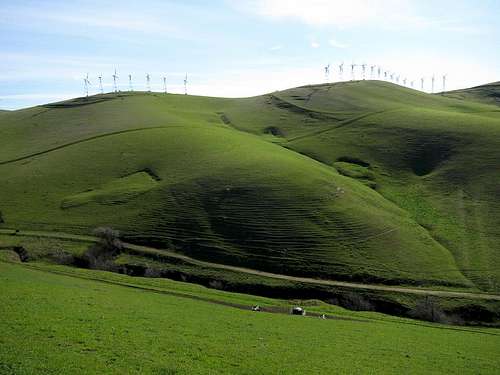
 Brushy Peak from the West Side Loop
Summit Access:
This is the bugger. Access to the summit of Brushy Peak is restricted and technically available only via guided tours held by the Livermore Area Recreation and Park District. Even with this restriction, there is little to stop visitors from reaching the summit but for a simple barbed wired fence 150 feet below the summit area. The summit is fairly visible from most directions, though a quick run up the southwest side might be an option for impatient and lawbreaking individuals. Night visits are also an option (see park hours), otherwise contact the LARPD at 925-373-5700 to sign up for a tour. You can also check out the upcoming dates for the summit tours listed on the LARPD Brushy Peak Regional Preserve webpage. Several are held annually especially in the spring.
Park Hours:
Brushy Peak Regional Preserve’s hours vary with the season and generally coincide with 8:00 AM to sunset each day. The hours only apply to the parking lot and ample parking outside the gate is available and adds all of 30 seconds to your journey. Park curfew is from 10:00 PM to 5:00 AM.
Entrance Fees:
No fees for entry or parking!
| East Bay Regional Park District EBRPD Website Information: (888) 327-2757 (option 3, extension 4565) | Livermore Area Recreation and Park District LARPD Website Information: (925) 373-5700 |
Current Conditions
Click Here for the Current NOAA / National Weather Service Forecast
When to Climb
Brushy Peak is a great place to visit year round, but it can get quite hot during warmest days of the summer months. The area is greenest from late November through early May.
 |
 |
 |
 |
 |
 |
Camping
Be serious....