
-
 8641 Hits
-
 87.19% Score
-
 24 Votes
|
|
Area/Range |
|---|---|
|
|
46.77188°N / 11.01300°E |
|
|
Hiking, Mountaineering, Ice Climbing, Mixed, Scrambling, Skiing |
|
|
Summer, Fall, Winter |
|
|
11903 ft / 3628 m |
|
|
1 - Overview
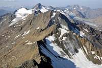
 Ötztaler Hauptkamm seen from Taschachwand |
The Ötztal Alps belong to the largest mountain ranges of the eastern Alps. While not as high as Bernina Group, Ortler / Ortles Group or Hohe Tauern the range nevertheless is considered the most glaciated one west of the Rhine River Valley (the natural boundary between western and eastern Alps). To the north long ridges (Geigenkamm, Glockturmkamm and Kaunergrat) gradually extend into the Inn River Valley, while to the south there is a sudden drop into Vinschgau / Val Venosta, the separating line being the Ötztal Alps Main Ridge, Ötztaler Hauptkamm.
As a supgroup of the Ötztal Alps, Ötztaler Hauptkamm is neither the largest nor tallest one either. Its highest mountain, Hintere Schwärze reaches 3628m, about 150m shy of Wildspitze on the Weißkamm Ridge. Still, almost all of the mountains on the main ridge reach and exceed 3000m, forming a considerable boundary between northern and southern Alps. Geographically the main ridge stretches from Hochjoch / Giogo Alto in the west to Timmelsjoch / Passo del Rombo in the east. The northern boundary is Venter Tal while the southern one follows the line Schnalstal / Val di Senales - Pfossental / Val di Fosses - Pfelderer Tal / Val di Plan. There is no road pass east of Timmelsjoch / Passo del Rombo but several important saddles like Hochjoch, Hauslabjoch or Marzelljoch have been used for transhumance since prehistoric times.
 |  |  |
The main ridge divides into three parts:
- The Western Main Ridge, a west to east running ridge with a northern side ridge to Saykogel and Kreuzspitze
- Ramolkamm, a long ridge running south to north, which separates Venter Tal from Gurgler Tal
- The Eastern main Ridge running south-west to north-east and ending above Timmelsjoch / Passo del Rombo
The Geology of the main ridge follows the same pattern as found all over the group. It mainly consists of Gneiss, metamorphic rock which contains up to 20% Feldspar and additional admixture of Mica. The amount of Feldspar determines the solidity of the rock between solid and very brittle and schist-like. Mica is the first of the components to erode, leaving a red, rusty hue on most of the rocks. Plants can easily take hold in the crevices of the rocks, further contributing to its erosion. In consequence, the summit elevations are not much higher than the glaciers at their bases, often offering easily accessible routes to the tops.
 |  |  |
Best known among the summits of Ötztaler Hauptkamm is Similaun. Located in the central part of the wetsern main ridge, the mountain can be easily reached from Similaunhütte at its base, which can be reached easily across some of the high passes of the ridge. It gained additional notoriety by the dicovery of Ötzi (see next paragraph). Other important mountains are the Ramolkögel, Diemkögel and Seelenkögel, all three clusters of three summits located close to each other. And of course, Hintere Schwärze / Cime Nere holds the record as the highpoint of the subgroup.
Last not least, in 1991 the natural mummy which was dubbed Ötzi (also Ötzi the Iceman, the Similaun Man, the Man from Hauslabjoch, Homo tyrolensis, and the Hauslabjoch mummy), was found between Hauslabjoch and Tisenjoch, to the west of Similaun. He was probably a high altitude shepherd living in the time around 3300BC. The remnants of his body as well as his clothes and belongings are displayed in the South Tyrol Museum of Archaeology in Bolzano. Also see the wikipedia article.
Today the Ötztal Alps Main Ridge is the border between Austria and Italy but in the past was the central part of the Austrian county of Tirol. Along the boundaries of old Tirol the Euroregion Tyrol–South Tyrol–Trentino was established in 1996 to promote cross-border cooperation between the parts of the old county.
2 - Ötztaler Hauptkamm on SP

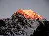
Ötztaler Hauptkamm seen from Weißkugel
- Hinterer Wurmkogel
- Hintere Schwärze / Cima Nera
- Similaun
- Mutmalspitze
- Ramolkogel
- Hinterer Spiegelkogel
- Schalfkogel
- Fineilspitze
- Scheiberkogel/Cima Rocciosa
- Hinterer Seelenkogel
- Mittlerer Seelenkogel
- Hangerer
- Hohe Wilde
- Kreuzspitze
- Saykogel
- Grawand / Croda di Cornachie
3 - The Summits

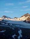
Schematic map of Ötztaler Hauptkamm
- Banker Kirchenkogel (3115m)
- Schermerspitze (3117m)
- Bankerkogel (3060m)
- Hinterer Wurmkogel (3082m)
![]()
- Schwenzerspitzen
![]()
- Äußere Schwenzerspitze (2993m)
- Vordere Schwenzerspitze (2904m)
- Mittlere Schwenzerspitze (2889m)
- Hintere Schwenzerspitze (2875m)
- Äußere Schwenzerspitze (2993m)
- Königskogel / Monte Rei (3055m)
- Ferwallspitzen
- Southern Ferwallspitze (2996m)
- Northern Ferwallspitze (2957m)
- Southern Ferwallspitze (2996m)
- Festkogel (3035m)
- Granatenkogel / Monte dei Granati (3304m)
![]()
- Essener Spitze (3200m)
- Hoher First / Monte Principe (3405m)
![]()
- Rauhes Joch (2926m)
- Hinterer Draunsberg (2825m)
- Mittlerer Draunsberg (2779m)
- Vorderer Draunsberg (2761m)
- Sechsspitzler (2655m)
- Plattenspitze (2517m)
- Karrenberg (2249m)
- Grinolspitze (2763m)
- Seewerspitze / Cima del Lago (3302m)
- Liebener Spitze (3400m)
- Gurgler Kirchenkogel / Cima della Chiesa (3180m)
- Hohe Mut (2659m)
- Heuflerkogel / Monte del Cumolo (3245m)
- Trinkerkogel / Cima Snella (3161m)
- Scheiberkogel / Cima Rocciosa (3135m)
![]()
- Rotmooskogel / Cima del Plan (3338m)
![]()
- Hinterer Seelenkogel / Cima delle Anime (3472m)
![]()
- Mittlerer Seelenkogel (3426m)
![]()
- Vorderer Seelenkogel (3290m)
- Hochebenkamm (3166m)
- Eiskögele (3228m)
- Hangerer (3021m)
![]()
- Rotegg / Cima Rossa (3341m)
- Langtalerjochspitze / Cima di Vallelunga (3157m)
- Hochwilde / L'Altissima (Hohe Wilde, N:3461m, S:3482m)
![]()
- Annakogel (3336m)
- Mitterkamm (3200m, 3194m, 3208m)
- Schwärzenkamm (3201m)
- Schwärzenspitze (2980m)
- Bannkogel (3309m)
3.2 - Ramolkamm
- Falschunggspitze / Cima Valsun (3363m)
- Karlesspitze / Cima di Quaira (3462m)
![]()
- Querkogel (3448m)
![]()
- Kleinleitenspitze (3445m)
- Schalfkogel (3540m)
![]()
- Diemkögel
![]()
- Hinterer Diemkogel (3400m)
- Mittlerer Diemkogel (3342m)
- Vorderer Diemkogel (3372m)
- Hinterer Diemkogel (3400m)
- Firmisanschneide (3491m)
- Spiegelkögel
- Hinterer Spiegelkogel (3426m)
![]()
- Mittlerer Spiegelkogel (3310m)
- Vorderer Spiegelkogel (3084m)
- Hinterer Spiegelkogel (3426m)
- Ramolkögel
![]()
- Kleiner Ramolkogel (3351m)
- Mittlerer Ramolkogel (3518m)
- Grosser Ramolkogel (3550m)
- Kleiner Ramolkogel (3351m)
- Nördlicher Ramolkogel (Anichspitze, 3428m)
- Manigenbachkogel (3313m)
- Latschkögel
- Southern Latschkogel (3357m)
- Northern Latschkogel (3386m)
- Southern Latschkogel (3357m)
- Gampleskogel (3408m)
- Zirmkogel (3281m)
- Stockkogel (3109m)
- Nörderkogel (3163m)
3.3 - Western Main Ridge
- Fanatspitze / Punta Fanat (3361m)
- Rötenspitze / Punta Rossa (3396m)
- Hintere Schwärze / Cime Nere (3628m)
![]()
- Mutmalspitze (3528m)
![]()
- Marzellspitzen / Punte di Marzell
- Eastern Marzellspitze (3555m)
- Central Marzellspitze (3530m)
- Western Marzellspitze (3540m)
- Eastern Marzellspitze (3555m)
- Similaun (3606m)
![]()
- Schröfwand / Croda Rotta (2890m)
- Wilder Hut / Monte Capello (2912m)
- Marzellkamm (3149m)
![]()
- Hauslabkogel (3403m)
- Saykogel (3360m)
![]()
- Sennkogel (3400m)
- Kreuzkogel (3340m)
![]()
- Kreuzspitze (3457m)
![]()
- Talleitspitze (3408m)
![]()
- Fineilspitze / Punta di Finale (3516m)
![]()
- Fineilköpfe / Punta dei Corvi
- Eastern Fineilkopf (3400m)
- Western Fineilkopf (3418m)
- Eastern Fineilkopf (3400m)
- Schwarze Wand / Coda Nera (3355m)
![]()
- Grawand / Crode delle Cornacchie (3250m)
![]()
- Graue Wand / Croda Grigia (3195m)
![]()
3.1 - Eastern Main Ridge


4 - Getting There
- Austrian part (N)
- From the north
From Germany the easiest way to reach the Austrian valleys of the Ötztal Alps is to take the Inntal Autobahn, a motorway, which connects Kufstein in the north-east with Bregenz in the west. In its western part the motorway gives way to a regular road which only near Bregenz turns again into a motorway, now called A14. In any way the motorway runs through the Inn valley. Between the towns of Imst and Landeck the Ötztal, Pitztal, Kaunertal and upper Inntal Valleys turn of south and reach into the Ötztal Alps Mountain Range.
- From the south
Here the easiest access is the Brenner Motorway, A22. Take it from Verona through Trento and Bolzano, cross the Brenner Pass and head down into the Inn Valley until you reach Innsbruck. Here turn westward on A12 and chose your valley of destination (see above).
- From the north
- Italian part (s)
- From the north
From Innsbruck take the Brenner Motorway to Sterzing / Vipiteno. Here take SS44 the road across Jaufenpass / Passo di Giove to Meran / Merano. There take SS38 into the Vinschgau Valley / Val Venosta.
Alternatively you can take the road through Ötztal across Timmelsjoch / Passo del Rombo, which also will take you to Meran / Merano.
- From the south
Take the Brenner Motorway A22 to Bozen / Bolzano where you need to turn onto SS38, direction Meran / Merano.The road turns west into Vinschgau Valley.
- From the north
5 - Accommodation
On both sides of the border you have the choice among a lot of hotel rooms and apartments. Here is a selection of links:- Ötztal accommodation
- Pitztal accommodation
- Kaunertal accommodation
- Vinschgau / Val Venosta accommodation
- More Vinschgau / Val Venosta accommodation
- Schnalstal / Val Senales accommodation
6 - Red Tape
The area around the main ridge have been declared "Ruhezone" (=calm zone). This means they are off limits for downhill skiing at all times of the year while hiking and climbing (again with the obvious restrictions) is allowed. No construction is allowed either.However, calmzone actually implies that you don't disturb any animaly in their habitat. Keep Quiet ;-)
7 - Weather Conditions
8 - Maps & Books
8.1 - Maps
The best maps are the ones by Deutscher Alpenverein (German Alpine Club) for Ötztaler Hauptkamm there are two:
- Ötztaler Alpen, Gurgl
Map No: 30/1
1:25000
ISBN: 978-3928777384
- Ötztaler Alpen, Weißkugel
Map No: 30/2
1:25000
ISBN: 978-3928777391
Kompass has some very good overview maps, scaled 1:50000 which show all the neccessary trails but don't go into too much detail:
- Ötztaler Alpen
Kompass Map WK43
1:50000
ISBN: 3-85491-049-5
- Vinschgau / Val Venosta
Kompass Map WK52
1:50000
ISBN: 3-85491-058-4
8.2 - Books
- Ötztaler Alpen
W. Klier
Alpenvereinsführer
Rother Verlag
ISBN: 3-7633-1123-8
- Ötztal
H. & W. Klier
Rother Verlag
ISBN: 3-7633-4094-7
- Pitztal
H. & W. Klier
Rother Verlag
ISBN: 3-7633-4058-0
- Vinschgau / Ortlergruppe
Kompass Wanderbuch 950
Kompass Verlag
ISBN: 3-87051-404-3
Overview books (both out of print) with 20+ routes in the Ötztal Alps
- Ötztaler Alpen, Silvretta, Ferwall (Bergwandern und Bergsteigen zwischen Timmelsjoch, Reschen und Arlberg)
S. Schnürer
BLV München 1990
ISBN: 3-405-13171-5
- Bergsteigen in Südtirol Band 2 (zwischen Bozen und Reschen)
S. Schnürer
BLV München 1982
ISBN: 3-405-12212-0
selinunte01 - Mar 24, 2013 11:29 am - Voted 10/10
Just an additionto the Maps-section: For all glacier and mountaineering activities in this area, the Alpenverein maps are - in my opinion - a must: Map number 30/1, Ötztaler Alpen, Gurgl, scale 1 : 25.000, 2008 Map number 30/2, Ötztaler Alpen, Weißkugel, scale 1 : 25.000, 2003
Gangolf Haub - Mar 24, 2013 12:11 pm - Hasn't voted
Re: Just an additionHi Michael, ich habe die Karten nicht selbst und war mir nicht sicher, welche davon den Hauptkamm betreffen... Danke
Vid Pogachnik - Mar 24, 2013 4:36 pm - Voted 10/10
Re: Just an additionHi, Gangolf! Are you sure that http://www.atlanteitaliano.it is giving you anything? Can you please check? Cheers, Vid
Gangolf Haub - Mar 25, 2013 7:25 am - Hasn't voted
Re: Just an additionSigh - you are right of course. They deleted the domain and now it is available under http://www.pcn.minambiente.it/GN/index.php?lan=en
Jurgen - May 17, 2013 3:08 am - Hasn't voted
A Minor Correction..The picture used for the Ramolkogel isn´t the Ramolkogel, but the Hinterer Spiegelkogel. It would be more accurate to use a picture of the Ramolkogel, or did you use this one on purpose? Furthermore, this page provides an excellent overview!
Gangolf Haub - May 17, 2013 11:36 am - Hasn't voted
Re: A Minor Correction..Thanks Jurgen, I guess I mixed up the numbers of the pictures.