

Scott - May 8, 2013 12:04 pm - Voted 10/10
Baru vs ChirripoIs Baru really farther from the center of the earth than Chirripo? They aren't that much different in latitude.

Wolfgang Schaub - May 12, 2013 9:54 am - Hasn't voted
Re: Baru vs ChirripoBaru = 3474 m above sea level, corresponding to 6,377,633 m from the center of the Earth.
Chirripo = 3820 m above sea level, corresponding to 6,377,554 m from the center of the Earth.
Take the latitudes and enter them into the calculation formula at http://bergliste.at/abstand.html -- that's what I did.
I admit the race between Chirripo and Baru is not finally decided, before we do not take the correction factors into account that need to be applied due to variations of the density of the Earth crust. See my comment to Klenke below.
Wolfgang Schaub - May 21, 2013 3:18 am - Hasn't voted
Re: Baru vs ChirripoScott,
my sincere apologies! As it turns out that the calculation tool that I used provides only the basic distances from the center of the Earth, and the altitudes above sea level have to be added, it indeed turns out Cerro Chirripo is "higher" than Volcan Baru.
The calculation for Chirripo is 6.377.554 + 3820 = 6.381.374.
There are even MORE errors in my list: Mt. Kinabalu turns out 68 m "higher" than Kerinci for Asia, and Everest remains the highest one, unless Carstensz Pyramid is regarded Asian.
And I have to review Europe (Mulhacen vs. Etna), and the Antarctics: Does Mount Irving really belong to the Antarctics? Being north of the 60 degree latitude it is not covered by the Antarctics Treaty, and therefore seems to be a truly British mountain.
In due time I will come up with a revised list of champions. I take the opportunity to thank you and all others for their input.
Wolfgang

Klenke - May 9, 2013 3:02 pm - Hasn't voted
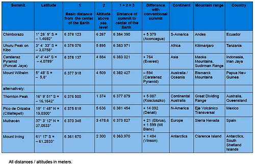
Wrong DistancesThe distances to the Center of the Earth reported here are very wrong. For instance, 20,566-ft Chimborazo's true distance is 6384.386 km and 12,284-ft Kerinci's true distance is 6381.997 km. The 2.389 km difference between these two is roughly the difference in the two peaks' heights above sea level, which makes sense given their approximately equal latitudes relative to the Equator (1.4676 North for Chimbo and 1.6967 South for Kerinci).
I have derived the exact equation for the Earth-Center distance of any point on, under, or above the Earth, as a function of latitude and elevation above (or below) sea level. And the numbers in the table above or quite incorrect. The Earth is an oblate spheroid and its elliptical nature with respect to latitude must be taken into account.
Paul

mrchad9 - May 9, 2013 4:19 pm - Voted 10/10
Re: Wrong DistancesSo you mean the table above is mistakingly using the distances of sea level at the mountain's latitude from the center of the earth and not the summit distance?
Klenke - May 10, 2013 1:11 am - Hasn't voted
Re: Wrong DistancesI'm not sure where those numbers are coming from. I was only showing through my values how the difference in height of two summits at relatively equal latitudes amounts to the same difference in distance to the center of the Earth.
The runner-up to Chimborazo is Huascaran. It is shy of Chimborazo by only 64 feet (i.e, that much closer to the Center). There is of course uncertainty in the two peaks' elevations and the accuracy of the WGS 84 data defining sea level on the spheroid.
Wolfgang Schaub - May 12, 2013 9:37 am - Hasn't voted
Wrong Distances?Dear Klenke,
Thank you for your comments and criticism. I took the values from the formula used in http://bergliste.at/abstand.html, and the latitudes from Information in the internet.
Can you tell me what PRECISELY your criticism is founded upon?
The general calculation formula for the Earth Spheroid is as follows:
R = Re[1 – f.sin2(geographical latitude)]
Where Re is the radius at the equator and f the flattening rate. The most exact values for the entire globe are taken from the WGS84 (World Geodetic System 1984):
Re = 6378137 m, f = 0,00335281.
In addition, the shape of the Earth differs slightly from the ideal ellipsoid due to local variations in the density of the Earth crust: Above places with high density the sea level expands, which means that a local factor has to be added (likewise: subtracted in places above low density) to (from) the basic radius of the Earth ellipsoid, hence the small differences to the ideal values.
I agree with you about the uncertainty re Huascaran vs Chimborazo. I can only say that it is common BELIEF that Chimborazo is the champion, as long as more accurate data are not available.
So if you collect the "new" Seven Summits you better climb Chimborazo AND Huascaran, to be on the safe side.
Welcome!
Wolfgang
Wolfgang Schaub - May 14, 2013 1:17 am - Hasn't voted
Re: Wrong distances?Paul, I wait for the equation that you have in mind. Can you notify me separately once you post it, please?
Wolfgang
PS: And note my posting was merely meant to provoke thought and provide an excuse for the thousands of mountaineers who believe they must follow the classical Seven Summits concept and realize they cannot make it. Here is just a new list to work on - until they realize that even the smallest hill can be satisfying, if it only is special.
Klenke - May 14, 2013 4:44 pm - Hasn't voted
Re: Wrong distances?Given some gumption on my part, I could probably find the farthest point from the Center of the Earth in every continent. That would be an interesting list and we owe it to you for thinking of it. Maybe when I put up the derivation page I'll divulge these new "Seven Summits."
Knowing what I know about the search process, I know the investigation can take a while because it is manual in many aspects. Plus there is the issue of maps not being very accurate (mainly on precise elevations) in certain regions, so there will be a lot of uncertainty.
Wolfgang Schaub - May 15, 2013 1:37 am - Hasn't voted
Re: Wrong distances?I did all this and it took me 2 weeks. Still there is uncertainty about the Antarctics. I came up with a mountain on the South Sandwich Islands that the world has never heard about, BUT: The South Sandwich Islands are north of 60 degrees South and therefore do not belong to the territory considered to be "neutral" in the context of the Antarctic Treaty. They are British and should not considered to be "Antarctic". So this would be the first candidate to review and revise.
mrchad9 - May 16, 2013 2:12 pm - Voted 10/10
InterestingI like the idea here... but was also wondering if you have a comparison to the more traditionally accepted 7 summits? I assume to create this list you must have compared to the others to validate which was higher. For example... being able to see how much futher from the earth's core Chimborazo is than Aconcogua. It would be a nice addition.
Wolfgang Schaub - May 17, 2013 2:43 am - Hasn't voted
Re: InterestingI will have to re-calculate my altitudes anyway. I'm just waiting for comments on Paul Klenke's equations and on a calculation tool that an Austrian freak offers, and then will come up with a revised list.

rgg - May 19, 2013 4:22 pm - Hasn't voted
The reason why the distances are incorrectI believe I found the reason why the distances from the center of the earth as reported in this article are wrong. Wolfgang refers to http://bergliste.at/abstand.html as his source. That site does indeed show a value labeled
"Abstand vom Erdmittelpunkt"
which, in English, means "Distance to the earth center".
However, the value given is not the distance to the center from the point requested, but the distance to the center from the surface of the WGS 84 ellipsoid directly below that point! (To be precise, "below" in this context means following the normal to the surface of the ellipsoid, not the direct line to its center.) Simply put, this value ignores the elevation above sea level.
The easiest way to verify this? Go to the site, enter a latitude (say 45) and an elevation (say 5000) and calculate. Then change the elevation to 0 and try again, and you'll get the same number.
Wolfgang Schaub - May 21, 2013 1:53 am - Hasn't voted
Re: The reason why the distances are incorrectDear Rob,
well observed! Behind the scene, there was already consent between Paul, myself and the webmaster of www.bergliste.at (Andy) that exactly THIS is the crux. Andy is working to rectify his calculation tool accordingly.
But this is not the only inaccuracy. As Paul has shown, the height above sea level is always measured vertically, while it would be appropriate in this context to measure parallel to the line connecting the summit with the center of the Earth. Consequently the total of basic distance and altitude requires a small correction that will make peaks slightly higher, the more they are away from the equator.
And the third crux is the additional bulging of the Earth at places where big land masses are. How much this is, I don't know. Maybe it would add another couple of meters, the more the higher the peak and the surrounding area is.
I'm currently reworking my table and will come up with a revised version in a few days. In the meantime note please, that my intention in the first place was rather to create a new list and find out, with the help of summitpost users, whether I have identified the new champions correctly.
Wolfgang
Klenke - May 21, 2013 4:23 pm - Hasn't voted
Re: The reason why the distances are incorrectWolfgang,
Regarding the second paragraph, the gravitational acceleration vector is due to two components, gravity itself and centrifugal acceleration, with the direction of this vector being parallel with Ray Ra, which does not go through the center of the Earth except at the poles and at the Equator. This is the direction a plumb line makes and also the vertical direction elevations are measured with. More info in the last paragraph of this section of this wiki page. There might be a small variability in the true plumb line relative to Ra but this will be so small as to be negligible for purposes of this calculation. So there is really no further "adjustment" necessary for points not at the Equator (or poles).
Regarding the bulge of continental land masses: your assertion is correct but it is simply too difficult to track down what "mean sea level" was taken to be for all of the elevation surveys of the summits all over the world over the last 100 or more years, particularly if mean sea level is not a constant due to the gravitational effects of land masses tending to raise the sea level by a couple of meters around them, not to mention the change in what is considered mean sea level by advancements in technology and understanding (such as WGS 84). More here.
Wolfgang Schaub - May 22, 2013 3:08 am - Hasn't voted
Re: The reason why the distances are incorrectAha! Now I understand. Thank you, Paul, and thanks especially for your patience with me ignorant mountaineer.
In the meantime I have recalculated the distances from the Earth center for all my new Seven Summits candidates (by adding Z), and it appears part of my proposed candidates turn out wrong. Particularly "bad": Everest remains the highest of Asia, UNLESS I discuss it away and declare Carstensz Pyramid Asian. Jee, I can't help: The gist of what I wanted to create is all gone!
A revised table will show up in a few days.
Wolfgang
Klenke - May 22, 2013 7:06 pm - Hasn't voted
Re: The reason why the distances are incorrectJust use the equation I provided. The maximum error of "just adding Z" instead of using the equation is about 69m [225 feet] at 45 degrees latitude. The error lessens as you trend away from this latitude.
Comments
Post a Comment