Intro
After my experience with Flat Top, I decided to write this trip Report as a way to give people all the information they need about climbing Flat Top as of July 2013. There has not been much in the way of updates in quite some time and I felt like I had to piece together information from the main page, route report, and Trip reports to get the information I needed to get to the top. Additionally, there have been changes on the mountain that I felt everyone should be aware of. There are new signs, a new trailhead, and 'Public Use' signs along South Fork Road. There are no longer any 'No Trespassing' signs at any point along the route and the locals we met on the road were very friendly in helping us along our way. I believe that the route up Lewiston Ridge to Flat Top is likely completely legal based on my experience. Please vote if you find this page helpful!
Driving There
Your driving destination is the old mining town of Ophir, basically 20 miles south of Tooele. If coming from downtown or North, you can go through Tooele to get to Ophir. If going from the South, you can go through the Saratoga Springs area and through The Ranches at Eagle Mountain. Proceed west on 73 for close to 28 miles (not exact) with the road going over Five mile pass. Watch the mile posts as the road you need for the turnoff to Ophir (on the right) is between mile posts 4 and 5. The turnoff to Ophir is paved all the way to
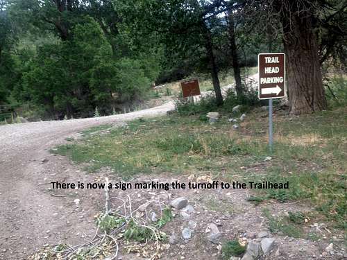
Ophir, which is up the canyon about 5 miles to the east. Ophir is a very cool old mining town that now has a bunch of restored homes, mine cars and tracks, and buildings. It is worth spending 20 minutes taking a bathroom break and checking out all the historical stuff there as there is no bathroom at the trailhead. They even have cold drinks for sale in the main boxcar with lots of cool memorabilia. Go slowly through town and after about 1.2 miles watch for a rough road taking off to the right---there is now a sign marking the turn to the trailhead. It is just before the water from Ophir Creek is diverted into a pipe.
![Turn off to South Fork Road (Trailhead)]() Turn off to South Fork Road (Trailhead)
Turn off to South Fork Road (Trailhead)If you go past this turnoff, you'll find the road narrows and turns slightly north. Stop and go back.
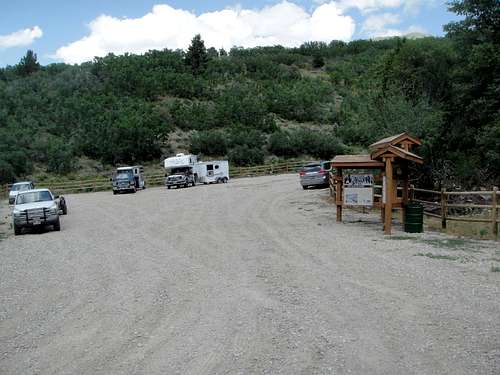
There is now a nice big parking lot and signage at the Trail Head, with information about the South Fork Loop Trail, although no mention of Flat Top or Lewiston Peaks. From the trailhead, the road gets REALLY rough in spots after about 1/3 of a mile. To proceed, a very high clearance 4WD vehicle and lots of patience would be needed. I imagine most will start from the trailhead since the road is a nightmare and would be impassable with any vehicle if wet.
Once there, the route took us about 3 1/2 hours round trip running easy and hiking the steep and technical portions. Another Summitpost member said that it took 4 hours up and 2 1/2 back going an easy, steady pace.
![Trailhead in 2013]() The new and improved Trailhead as of July 2013 up South Fork to Lewiston Peak and Flat Top Mountain. The locals were very friendly.
The new and improved Trailhead as of July 2013 up South Fork to Lewiston Peak and Flat Top Mountain. The locals were very friendly. The Route
Phase 1 - The road to the 8000' saddle and up to the 9000' Clearing
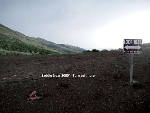
Starting at the trailhead at 6725 feet, simply proceed (south) up the rough road 2.3 miles to the saddle near 8000 feet. Prior information that I read said 3 miles, but we definitely clocked it at just under 2.3 miles. (Don't worry, the cows are easily spooked and will move quickly out of your way when they see you coming). There is a split at the 1 mile mark, just stay to the right and stay on the road to the saddle at 2.3 miles. We ran in to some locals on the road who helped us know we were going the right way and were very friendly and told us the conditions of the road ahead. At the saddle, there is another loop trail sign that is a bit confusing as there are options to go straight, right, or left. At this point, you want to head up the spur road to the left (East-Northeast), which only goes a couple hundred meters before coming to a clearing.
![8000' Saddle - Time to turn left and head up]() 8000' Saddle - Time to turn left and head up
8000' Saddle - Time to turn left and head up![Looking back at the 8000' Saddle]() Looking back at the 8000' Saddle
Looking back at the 8000' SaddleAt the edge of the clearing is a rockpile and this is where the small trail up towards the Lewiston ridge starts. The trail starts heading back north in the direction of the trailhead. After a short distance, the trail will do a hairpin turn and hook back south---it is easy to miss, but the trail is now blocked with rocks and we put up an additional large cairn to try and make it obvious. The trail gets faint and can be easily lost from here, but it generally does large switchbacks across the mountain and stays farther to the south than one would logically expect. The climb is steep for about 3/4 of a mile and nearly 1000 feet of elevation gain until it begins to level out. If you have lost the trail by now, you will likely find it as things level out and the trail heads Northeast and only slightly gains elevation for a few hundred meters before dropping in to a clearing around 9000'.
Phase 2 - 9000 ft Clearing to 9600 ft Saddle
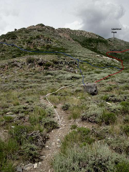
As you get to the low point of the clearing, you will notice a large square rock (pictured).
![Time to Choose - New Route or Traditional]() New Route is the Blue line on the left. Traditional route is more obvious at first but soon peters out.
New Route is the Blue line on the left. Traditional route is more obvious at first but soon peters out. You can continue forward this way (although I much preferred option 2) around the south side of the ridge as this is the more dominant looking and obvious trail at this point as detailed in this
trip report by Dennis Poulin:
"Once on top of this first hill, the trail meanders around some knobs and then traverses on the south side of point 9654. The trail dips through a wet brushy area before switchbacking and coming back up to another little saddle east of point 9654 and west of Lewiston Peak. I didn’t expect the trail to dip so much here and I think it dropped about 100 ft in elevation. Before the trail switchbacked up to this saddle I saw a cow elk with her calf."
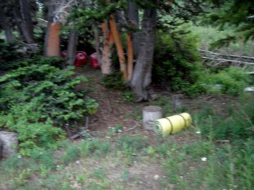
I would add that the trail doesn't gain much elevation as it goes around the flanks of the mountain and the big switchback is probably less than 200 meters after where the trail dips through the wet, bush and tree covered area that is infested with bugs, you can't see where your feet are going, and where you lose the trail because the foliage is so dense. It switches back the other direction (west northwest) just as you climb up to another subtle ridge that makes it look like you are going to drop again through another similar area. Once you take the switchback, you climb right up to the 9600' saddle. As you come up to the saddle, if you keep going the same direction and start a few feet down the other side, you will see a fuel cache to your left (west).
Option 2 (Up): On the way up, were lucky enough to run in to a kid and his mother that had done all the Oquirrhs and told us about this new route that they prefer taking. It looks less intuitive at first but ends up being a shorter and much better route in my opinion. As you come to the rock, take a left immediately or after about 50 meters and work your way up between the two craggy areas (as pictured). Within 100 meters, you should find a decently well defined trail (for this mountain!) that wraps around the north flanks of the Lewiston Ridge. This route also stays low, goes through a tree covered area, and then switches back up the same 9600' saddle. It is almost a mirror image of the route on the other side, minus all the crappy stuff and the big elevation drop through the wet, brush and tree covered area. The trail loses definition as you come up to the saddle, but you will see the fuel cache as you approach the saddle.
![Fuel Cache at 9600' Clearing]() Fuel Cache at 9600' Clearing - Traditional route is on the other side of the ridge. If you're coming down, the new route is on this side with the fuel cache and heads back in the direction of the Lewiston Ridge but goes downhill. Seems counter-intuitive but it will soon turn back in the right direction and is the way to go and is a better route.
Fuel Cache at 9600' Clearing - Traditional route is on the other side of the ridge. If you're coming down, the new route is on this side with the fuel cache and heads back in the direction of the Lewiston Ridge but goes downhill. Seems counter-intuitive but it will soon turn back in the right direction and is the way to go and is a better route.
Phase 3 - Lewiston Ridge to the Summits
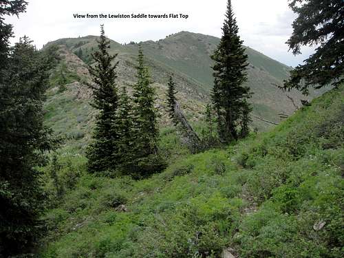
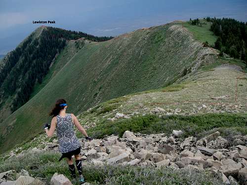
![Lewiston Saddle to Flat Top]() This is the view at the Lewiston Saddle looking up the ridgeline to Flat Top
This is the view at the Lewiston Saddle looking up the ridgeline to Flat TopOnce you reach the 9600' saddle, simply proceed east up the ridge. Nearly all of the climbing stays right on the ridge or just to the left of the ridge, never straying more than about 20 meters from the ridgeline. This will climb steadily up to Lewiston Peak where there is a cache and summit register. From here, you can see Flat Top 1 mile off to the North-Northeast. Simply descend steeply down the North face of Lewiston, staying to the left (west) when in doubt. It is pretty steep but after a few hundred feet of vertical descent, you will reach the saddle between Lewiston and Flat Top.
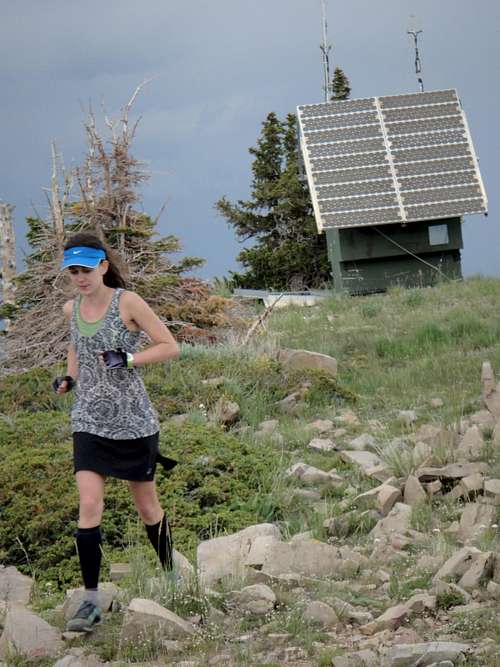
From here, it is pretty easy going all the way up to Flat Top. Simply stay on the ridge or just to the left (west) of the ridge and it will carry you up to a false summit about .4 miles from the top. Once there, continue up on the ridge and just to the left of the ridge all the way up to the summit. There is a cache on top and about 100 meters to the North is what appears to be some sort of solar powered weather station. We overshot the top as we saw the weather station first, and then went back to the top after going over to check out the weather station. From the top there are views of mountains in all directions from Nebo to Central Wasatch and around to Deseret Peak. Also of note is that it looks like coming up the other side of the mountain from the Fairfield area seems like a viable option that may be shorter. Anybody with any information on this, it would be much appreciated if you would contribute.
![Flat Top Summit Weather Station]() Flat Top Summit Weather Station
Flat Top Summit Weather StationGetting down
It appears that as of July 2013, the only legal way down is to come back the way you came. However, there are a few notes of interest on the way down.
1) When you get back to the saddle between Flat Top and Lewiston, if you start about 10-20 meters up Lewiston, you will see a trail breaking off slightly to the right. This trail bypasses the summit of Lewiston and shortens the way back. It gains some elevation along the way and eventually dumps you back on the Lewiston Ridge.
2) If you, like me, are coming down from Lewiston and don't want to go back the traditional route (as it is crappy and slow), you will have to locate the fuel cache and then turn around nearly 180 degrees and start back in the direction of the ridge (east northeast) but ip the ridge you just came down, trend down until you find the trail. (I am hoping someone can define and mark this area better in the future.) The trail will continue for a ways until it switches back west and starts back toward the direction you feel you need to be going. It will continue around the North flanks of the mountain down to the 9000' clearing. If for some reason you don't find the trail, simply switchback to the west and drop elevation slowly through the woods as you wrap around the North flanks of the ridge. You will be in tree cover the whole time and you will eventually pop out near the 9000' clearing.
3) You will follow the trail from the 9000' clearing until you start to drop steeply downhill again. We lost the trail right as it started to drop steeply, but found it again after cutting straight down. It seems the trail continued to counter-intuitively continue forward (West-Southwest) for quite some time until it switched back. Soon you will be back down to 8000' saddle and it is a quick jaunt 2.3 miles back to the trail head (unless of course you managed to get a high clearance 4WD vehicle to the 8000' saddle).
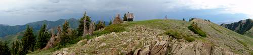
![Flat Top Summit Panorama]() Flat Top Summit Panorama
Flat Top Summit Panorama
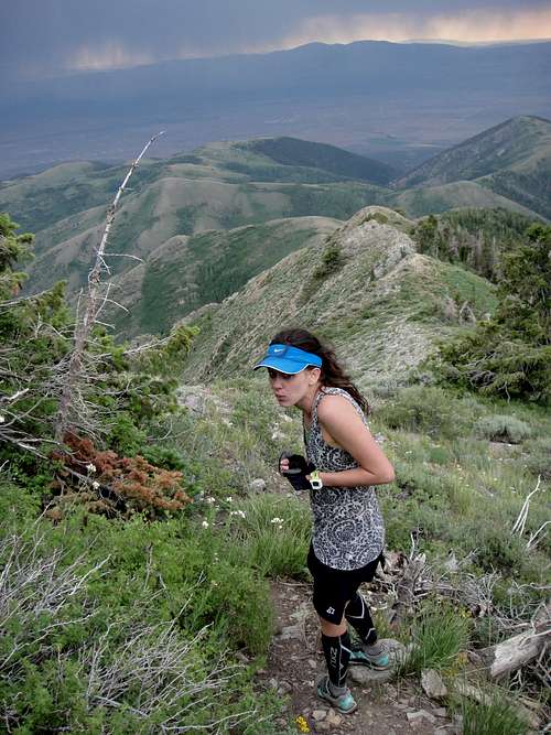
![Ridgeline from Flat Top to Lewiston]() Ridgeline from Flat Top to Lewiston
Ridgeline from Flat Top to Lewiston![We got chased off the mountain by a Thunderstorm]() We got chased off the mountain by a Thunderstorm
We got chased off the mountain by a Thunderstorm


Comments
Post a Comment