
|
|
Mountain/Rock |
|---|---|
|
|
46.96848°N / 11.10858°E |
|
|
Hiking |
|
|
Summer, Fall |
|
|
10535 ft / 3211 m |
|
|
Overview
The Schussgrubenkogel (or Schußgrubenkogel) is situated in the western part of the Stubai Alps main ridge. Although this main ridge is highly glaciated, the Schussgrubenkogel can be reached via an ice free route. Both the Hildesheimer Hütte and the cable cars of the Stubai ski area make it an easy accessible mountain. It’s broad summit offers a climb that is not so difficult. From the summit most of the major peaks of the Stubai Alps can be seen as well as a large part of the Ötztal Alps.
 Summit panorama from the Schussgrubenkogel towards the Ötztal Alps and western Stubai Alps.
Getting There
The summit can be accessed from two sides:
 Schussgrubenkogel seen from the Hildesheimer Hütte
- Hildesheimer Hütte 2900m
From the village Sölden (1368m) in the Ötztal a road goes in eastern direction up in the Windachtal. Until gasthof Fiegl (1968m) one can travel with a local bus (€7 fee), from Fiegl continu following the dirt road through the valley. At approximately 2100m a marked path to the Hildesheimer Hütte leaves the valley. This is the normal/preferable approach route to the Schussgrubenkogel.
- Ski station Eisgrat 3153m
At the end of the Stubaital there is a cable car that will bring you to the restaurant at 3150m.
Another possibility is the Hochstubaihütte (3174m), but from this hut the tour to the Schussgrubenkogel is much longer and demanding than from the Hildesheimer Hütte. Moreover in this trip the Schussgrubenkogel is not the highlight, but just a ‘sideshow’. The Hochstubaihütte can be reached from Sölden, which is a tough tour itself because of the 1800 altitude meters that have to be bridged. From Gasthof Fiegl the gain in elevation is still 1200m.
Route
From the Hildesheimer Hütte follow the marked path in NE direction towards the Bildstöckljoch. At almost 3100m the marked route bends towards the Gaißkarferner (glacier), leave the marks and stay on the ridge while scrambling/walking east to a very broad shoulder at about 3170m. At this shoulder you have reached the north ridge of the Schussgrubenkogel. You can follow a small spur towards the summit which is marked by cairns. The spur runs partly on, and partly just below the ridge to circumvent the most difficult sections. A nicer option is to stay on the ridge and scramble to the summit, difficulties never exceed UIAA I.
From the ski station go south, first you have to climb to the Isidor (3183m) via a secured path. Go down on the other side of this little summit and walk up to the shoulder of the Schussgrubenkogel where its north ridge starts. See above.
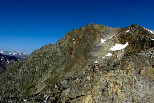
North ridge
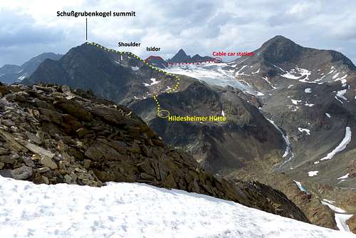 Summit routes: in yellow the route from the Hildesheimer Hütte, in red the one from the Ski Station Eisgrat (= Stubai valley)
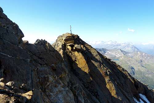 Summit
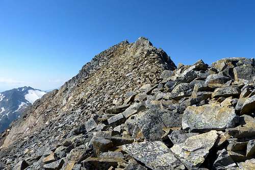
Red Tape
No permissions needed.
When to Climb
In the summer and early fall, so from June - October.
Camping
There is a campground in the village of Sölden.Maps
Alpenvereinskarte 31/1 Stubaier Alpen – Hochstubai, 1:25.000
Kompass 83 Stubaier Alpen, 1:50.000