
-
 7064 Hits
-
 78.27% Score
-
 9 Votes
|
|
Route |
|---|---|
|
|
47.46720°N / 120.81465°W |
|
|
Hiking, Mountaineering, Trad Climbing |
|
|
Spring, Summer, Fall, Winter |
|
|
One to two days |
|
|
5.5 (YDS) |
|
|
3 |
|
|
II |
|
|
Overview
Little Annapurna is one of the top 100 highest peaks in Washington and is typically known as one of the easiest ones to climb. The standard North Slopes route is a Class 1 ascent. This is quite strange as most Cascade Peaks are significantly more rugged on the north sides. However Little Annapurna breaks this rule and has a steeper south face. This would be the exciting way to climb a peak with spectacular views. This climb would make most sense to do as a carryover as rappelling the south face route would only add ugly slings on the mountain and increase the danger.
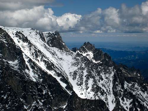 South Face of Little Annapurna from Argonaut
Getting There
The best approach for this climb is the route up Crystal Creek on the south flank of the Stuart Range from the Ingalls Creek Trail. From Leavenworth head east on Highway 2 to the US 97 junction and turn south onto US highway 97. Go 7 miles and turn west onto the signed Ingalls Creek Road. Continue 1.2 miles to the end of the road which marks the trailhead at an elevation on 2,000 feet. Start up the Ingalls Creek Trail which is a very nice and gentle hike and in good condition as it follows along the north side of Ingalls Creek. After 5.5 miles you will pass the Fall Creek trail junction at a sign in a small section of old growth forest. Continue another 2 miles to a point where the Crystal Creek valley is directly above you to the north. Just before Crossing Crystal Creek leave the trail at 3,700 feet and begin hiking up moderate slopes avoiding thick brush when possible and following cairns up a small ridge separating Crystal Creek with a smaller creek just to the east. The slopes are never really that steep but it's enough to get your heart beating and sweating especially if you are carrying a heavy pack. Around 5,700 feet the angle eases and you begin a stretch of boulder hopping on very large boulders. Locate the best route through the boulders staying on the ridge in the middle of the valley as much as possible. At 6,000 feet you will arrive at the dry tarn which has a beautiful grassy meadow just to the north of it which makes an awesome place to camp. Sometimes if you are lucky the tarn will have water in it such as in early season or after a big storm. This approach takes 6-7 hours from the trailhead.
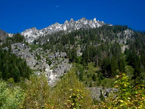 Looking up at McClellan Peak from Ingalls Creek trail Looking up at McClellan Peak from Ingalls Creek trail |
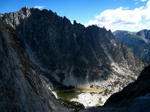
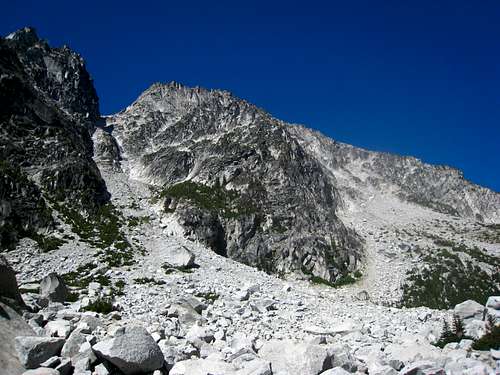 First views of the south face of Little Annapurna near the dry tarn. The gully is clearly seen heading up to the left. First views of the south face of Little Annapurna near the dry tarn. The gully is clearly seen heading up to the left. |
Route Description
From camp just north of the tarn, locate the obvious large gully to the west of the tarn with a massive talus apron at its base. Climb this gully to the 7,880 foot col between Little Annapurna and the spires to the south. With the exception of the talus apron at the base of the gully, the ascent to this col is surprisingly solid and offers fantastic scrambling. When you reach the top of loose scree and talus where you are presented with two gullies to choose from, take the right gully up a uniform 2-3 inch crack along a dihedral. Only the very top of this 75 foot crack may be low 5th class. There is another way around this crack gully by scrambling up broken but steep Class 4 rock to the right. Once above this section, continue up slightly easier Class 3 terrain to the right of the main gully and up some slabs and featured rock until you can traverse left into the main gully itself a 300-400 feet below the col. The final ascent in the gully is up very solid, slabby granite with enough features to keep the climb at Class 4. There is a short section just below the col where the slabs get steeper making the final 50 feet a little scary and thin. Be very careful here. Once at the col the gully is done and the real fun begins.
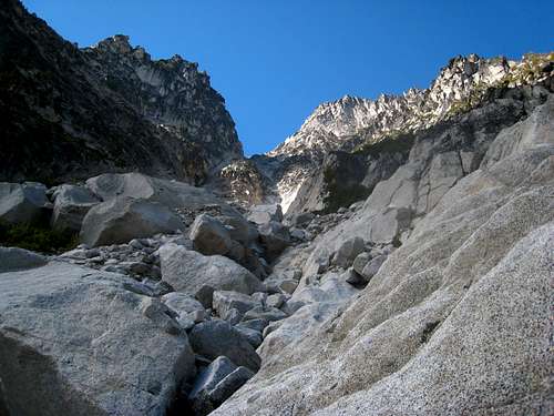 Climbing up the gully in a class 3 section Climbing up the gully in a class 3 section |
 View down to the tarn from the gully View down to the tarn from the gully |
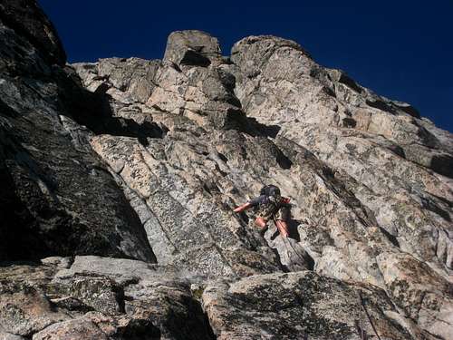
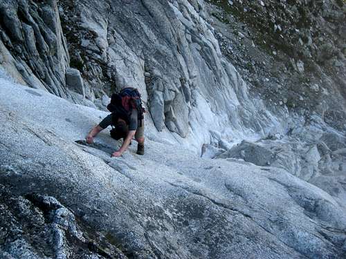 Josh climbing an exposed slabby section Josh climbing an exposed slabby section |
Once at the col, turn right and ascend 100 feet up Class 2-3 terrain to the base of the 450 foot south face. Begin climbing up a large obvious crack to the right of the huge gully which cuts the south face. Climb a full 60 meter pitch trending slightly rightward and belay off a large horn or a trad anchor. This first pitch is beautifully solid and offers plenty of protection and goes at 5.5. The second pitch also goes a full 60 meters at 5.5 and continues up the large chimney which begins about 20 feet right of a large ledge 3/4 the way up the south face. When the rope runs out, the final pitch is a 30 meter Class 3-4 romp to the summit plateau. The crux of this pitch is a short squeeze through a couple large blocks just below the summit. The true summit is the block just to the right and is a 15 foot scramble to stand on the highest point.
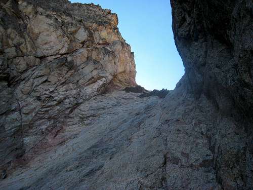 The final scary part of the gully The final scary part of the gully |
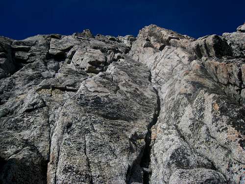 Looking up the first pitch up the obvious crack Looking up the first pitch up the obvious crack |
 Josh leading P2 with the chimney trending up and left Josh leading P2 with the chimney trending up and left |
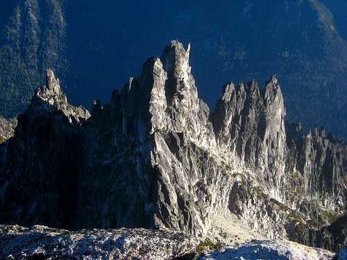 Looking down on the spires south of Little Annapurna Looking down on the spires south of Little Annapurna |
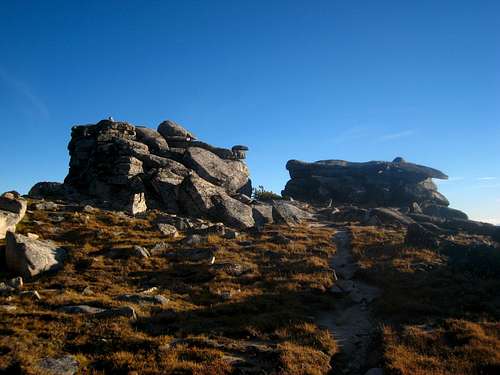 Summit rocks of Little Annapurna Summit rocks of Little Annapurna |
Descent
Do not rappel the route! The descent down the gully would also really suck. Walk off the northeast side of the mountain down to Crystal Lake at 7,000 feet. Traverse around the south side of Crystal Lake then follow it's outlet stream (Crystal Creek) down the valley back to your camp at the tarn. There is a lot of boulder hopping from Crystal Lake down the valley so the descent takes quite a while. Plan to avoid making this talus descent in the dark unless you have great night vision!
Map
Essential Gear
A thin 60 meter rope, single rack of BD Camelots to 3" and a set of nuts. The rock on the south face is so good and relatively simple you would really have to mis-step to fall. Helmets may be good to wear as the gully does have some loose spots.
External Links
Brown Fred has some info on this route as well as the spires to the south including the Horizontal Sire.