
-
 6007 Hits
-
 78.27% Score
-
 9 Votes
|
|
Mountain/Rock |
|---|---|
|
|
46.57915°N / 11.76509°E |
|
|
Hiking, Trad Climbing, Big Wall, Scrambling |
|
|
Spring, Summer, Fall |
|
|
8383 ft / 2555 m |
|
|
Overview
 Stevia subgroup of the Puez - Geisler Group Stevia subgroup of the Puez - Geisler Group |
Munt dla Stevia is located in the midst of the Puez-Geisler Group in the Western Dolomites. It is more than just a mountain: according to the German Alpine Club DAV the greater group subdivides into three subgroups, Geisler Group, Puez Plateau and Stevia Group, which gives an indication of the size of this mountain. The Stevia Group itself subdivides in four summits, three of which are directly linked together: Muntijella, Munt dla Stevia and Steviola. The fourth, standalone mountain is Col da la Pieres. Munt dla Stevia is separated from the remainder of the Puez - Geisler Group by Cislestal / Val Cisles in the west, Langental / Vallunga in the south and the valleys leading up to Forcella Forces de Sielles in the north and east.
Munt dla Stevia has everything you expect of a mountain: at 2500m elevation there are three hiking routes to its top, two vie ferrate lead into the group from its sout and north whereas about a dozen climbing routes run up its west and south faces and the separately located Torre Firenze in the west. There is a hut right close to the summit, the shortest hiking route can be done in less than two hours and thanks to its location, views are veritably breathtaking. Yet, Munt dla Stevia is generally overlooked - up to today it didn't even have a page on SP. Why?
 |  |  |
The most obvious reason is the fact that it is located in an area with so many higher and more impressive peaks. Munt dla Stevia itself - besides the vertical climbing walls can only boast a picture perfect summit meadow. There is a highpoint (rather more than one) but you wouldn't really call it a summit. The slpoed summit meadow simply ends in a breakoff ridge above the west face, one of the spots on the ridge is higher than the others but that's it.
 A tree with a view - Sella and Langkofel Groups
People visit Munt dla Stevia for various reasons: climbing, hiking, looking among them. But there's one thing everyone agrees to who has been to its top: you leave behind the buzz of Gröden / Val Gardena with its very busy tourist villages St. Christina and Selva / Wolkenstein. Step on one of the trails and you'll gradually lift yourself from the crowds and chaos. Yet you can still observe it, watching from more than 1000m up above.
Munt dla Stevia is the westernmost mountain of the Puez Group The group forms a plateau around the deep glacier-cut Langental / Vallunga, the mouth of which it guards from the north. To be precise, its southern cornerstone, Pela di Vit / Steviola guards the entrance of the valley and with it so does the ruin of Wolkenstein Castle, which is located at 1600m in the south face of the mountain. Today the castle conists of little more than one remaining wall but in medieval times it held watch over the important trade routes across Grödner Joch / Passo Gardena and Sellajoch / Passo Sella. The castle was built in the 13th century but was already destroyed in the 16th.
 |  |  |
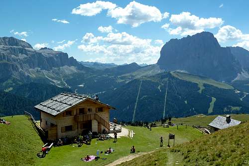
Close to the castle a relatively new via ferrata has been built, which cuts through the Pela di Vit / Steviola south face. Via Ferrata Sandro Pertini was named after the former president of Italy, who loved to spend his vacations in the Gröden / Val Gardena Area. The ferrata is considered very exposed and moderately difficult. It was built during 2003 and inaugurated in 2004. it tops out close to Stevia Hut, which is located right above the south face and offers wonderful views across Langental / Vallunga.
Getting There
 Wolkenstein / Selva Gardena beneath the Langkofel Group
Trailhead for Munt dla Stevia is Wolkenstein / Selva di Val Gardena. Several routes start here or in the hamlet Daunei above Wolkenstein.
- Take the Brenner Motorway A22 to the exit of Waidbruck / Ponte Gardena.
- Turn onto S242 east to Wolkenstein / Selva di Val Gardena.
Route Overview
Troi San Salvester
This is the usual route onto Munt dla Stevia. Hike Cislestal Val Clsles out from Daunei. This route will run in a big bend towards Sylvesterscharte, from where a moderately exposed path leads you to Stevia Hut
Expresssteig
Expresssteig also starts at Daunei but leaves the normal route after a few hundred metres to the right. It runs very steeply through the Stevia west face until it reaches Sylvesterscharte. From here as detailed above.
 |  |  |
Forcella dla Piza / Nadelscharte
Also a normal route. It starts at Regensburger Hütte / Rifugio Firenze deep in Cislestal / Val Cisles. It heads to Nadelscharte between Stevia and Muntijella across very brittle terrain.
Via Ferrata Sandro Pertini
Already described in the overview section. Also, there is a separate route page for this ferrata.
 |  |  |
Nivesschartensteig
In ferrata guidebooks you will find a second via ferrata called Nivesschartensteig. It is rather a sequence of protected hiking trails (sentiero attrezzato) which lead from Wolkenstein / Selva across Munt dla Stevia and Col da la Pieres to Piz Duleda. The most common variation uses the trail through Forcella dla Piza / Nadelscharte to reach Stevia, then climbs the southern normal route to Col da la Pieres (first protected section) descends into Forcella Forces di Sielles (next protection) and the south ridge to Piz Duleda (protection near Forcella Forces di Sielles). It then descend towards Forca della Roa (protection) and back to Regensburger Hütte / Rifugio Firenze.
Climbing Routes
There are several interesting climbing routes to Munt dla Stevia. Most run through the west face of the mountain but there are also a few through its narrow north face. Also TorreFirence, located to the west of Stevia has some good routes as well as Steviola in the south. The Steviola routes in particular are snow free early in the year already so that the offer good spring climbing already.
Red Tape
 Langental with Stevia and Col da la Pieres to the right
Munt dla Stevia is located within the Natural Park Puez - Geisler, which has been created in 1977 and contains an area of 10,703ha. Within park boundaries any building activities are prohibited. Flowers, berries, mushrooms, minerals have to be left in their environment. Camping is prohibited and cars have to be parked in the official lots.
For further information on the park, take a look at the official website (German and Italian).
Accommodation
 Stevia Hut in front of Langkofel (right)
Accommodation is easy to find in the Gröden / Val Gardena Area. In July / August you'll need reservations, since the area can be quite crowded.
The closest campground I know is at Seis, about 20 minutes by car from the trailhead:
Weather Conditions
Maps & Books
Books
- Alpenvereinsführer Dolomiten: Puez / Peitlerkofel
E.E. Striebitz
Rother Verlag
ISBN: 3 7633 1307 9
- Klettersteige Dolomiten
H. Höfler, P. Werner
Rother Verlag
ISBN: 3 7633 3096 8
- Hülslers Klettersteigführer
E.E.Hülsler
Bruckmann Verlag
ISBN: 3 7654 4161 9
- Dolomiten 1
F. Hauleitner
Rother Verlag
ISBN: 3 7633 4248 6
Maps
- Gröden - Seiser Alm / Val Gardena - Alpe di Siusi
Kompass Map WK 076
1:25000
ISBN: 978-3850265164
- Bressanone/Brixen - Val di Funes/Villnösstal
Tabacco Map 30
1:25000
ISBN: 978-8883150302
- Val Gardena - Alpe di Siusi/Gröden - Seiseralm
Tabacco Map 30
1:25000
ISBN: 978-8883150050