
-
 5851 Hits
-
 81.18% Score
-
 13 Votes
|
|
Area/Range |
|---|---|
|
|
45.73660°N / 7.32138°E |
|
|
Overview

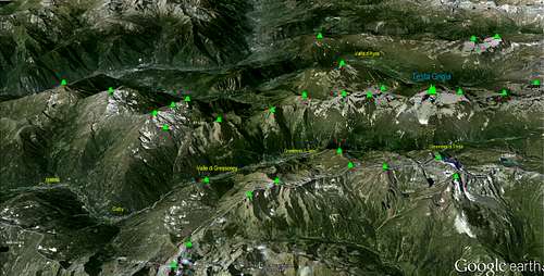
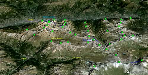
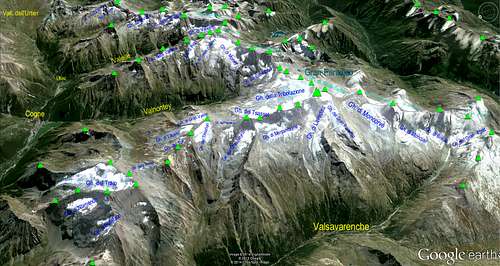
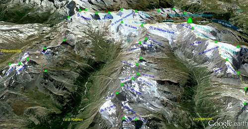
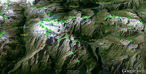
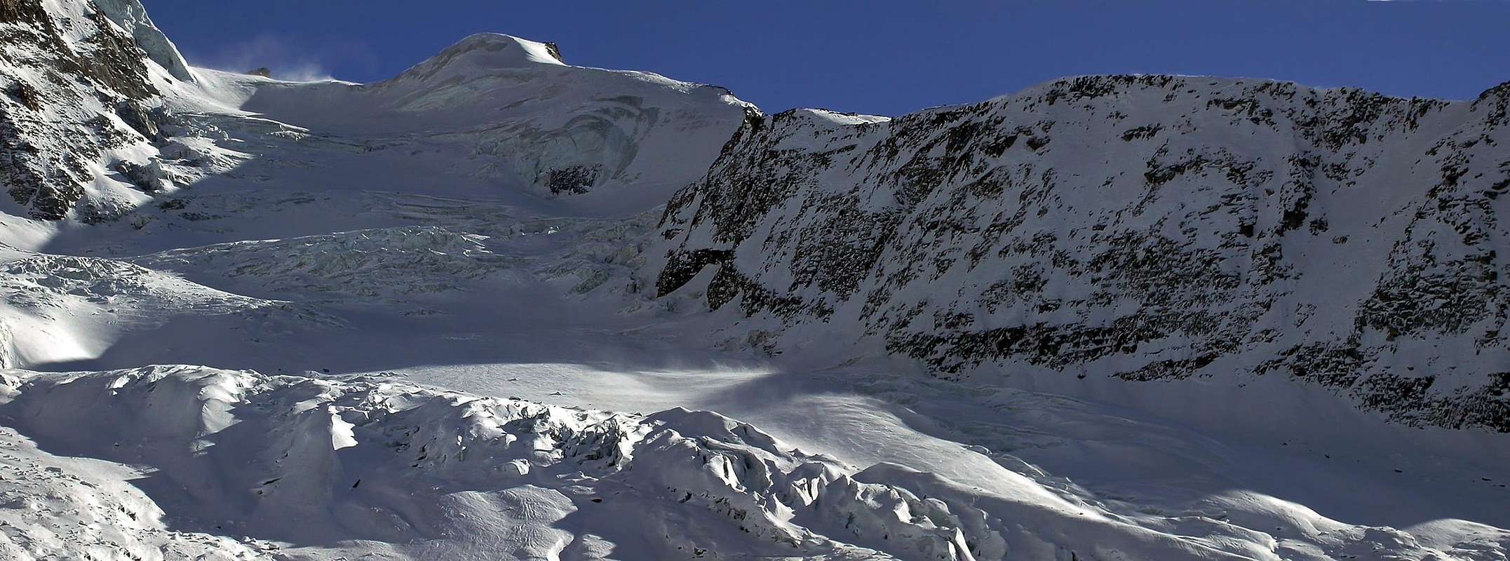
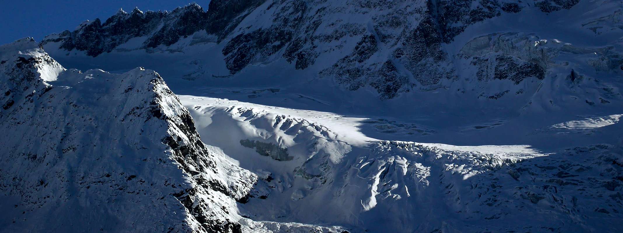
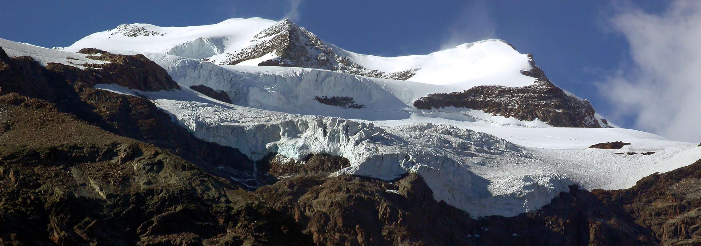
To speak of all the glaciers of the Valley of Aosta constitutes an arduous enterprise both for the mass and for the extension of the same ones; even if they are not comparable also to the immense Glaciers of the Himalaya they always constitute a notable basin of national water resources and, if adds to the bordering French and Swiss basins, European. Synthetically reassuming there is to underline that the same were in remote times the tributaries of the great Glacier Balteo that flowed on the axle of the actual River Dora Baltea on the axle Ovest/Sudest, or from the Mount Blanc (4.811m) up to the City of Ivrea in Piedmont; the great left side moraine, said "La Serra", near the same one it is the demonstration than it was cyclopic this great river of ice, really of a was ancient. Further testimonies remain in the sketch of the balconies that they mark the to flow of this giant, also superior to the 1.000 meters of quota, while the progressive withdrawal of the same one has given birth to born, in the time, a myriad of small lakes, some of which they ogle on the high ground near the aforesaid greenhouse. Of all the glaciers "Valdotains", of which you will read more ahead in the detail, detains instead there on the rivers that they gives birth and that then they meet in Dora Baltea, in turn great tributary near the City of Turin of the great River Po, that reaches the Adriatic Sea. Departing from the great Y to the feet of the Mont Blanc, originated from the union of the two principal Valleys of his or Val Ferret (to North) and Val Veny (to West) we list the same ones in order ydrografical, keeping in mind awry of the only rivers that a, if also small, glacier:
|
A) - In general left or Northern ydrographic of the Central Valley of the Dora Baltea from Courmayeur Resort to Pont Saint Martin:
B) - In general right or Northern ydrographic of the Central Valley of the Dora Baltea from Courmayeur Resort to Pont Saint Martin:
|
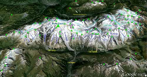
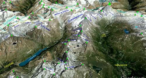
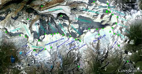
Parlare di tutti i ghiacciai della Valle d'Aosta costituisce un'ardua impresa sia per la massa che per l'estensione dei medesimi; anche se non sono comparabili agli immensi Ghiacciai dell'Himalaya pure sempre costituiscono un bacino notevole di risorse idriche nazionali e, se aggiunti ai confinanti bacini francesi e svizzeri, europee. Riassumendo sinteticamente c'è da evidenziare che gli stessi erano in tempi remoti gli affluenti del grande Ghiacciaio Balteo che scorreva sull'asse dell'attuale Fiume Dora Baltea sull'asse Ovest/Sudest, ovvero dal Monte Bianco (4.811 m) fino alla Città di Ivrea in Piemonte; la grande morena laterale sinistra, detta "La Serra", presso la medesima è la dimostrazione di quanto fosse ciclopico questo grande fiume di ghiaccio, proprio di un'era antica. Ulteriori testimonianze permangono nel disegno delle balconate che segnano lo scorrere di questo gigante, anche superiori ai 1.000 metri di quota, mentre il ritiro progressivo del medesimo ha fatto nascere, nel tempo, una miriade di piccoli laghi, alcuni dei quali occhieggiano sulle alture presso la serra suddetta. Di tutti i ghiacciai valdostani, dei quali leggerete più avanti nel dettaglio, ci soffermiamo invece sui fiumi che essi partoriscono e che poi confluiscono nella Dora Baltea, a sua volta grande affluente presso la Città di Torino del grande Fiume Po, che raggiunge il Mare Adriatico. Partendo dalla grande Y ai piedi del Monte Bianco, originata dall’unione delle due sue Valli principali o Val Ferret (a Settentrione) e Val Veny (ad Ovest) elenchiamo i medesimi in ordine idrografico, tenendo conto dei soli fiumi che posseggono a monte un, se pur piccolo, ghiacciaio:
A) - Lato idrografico sinistro o Settentrionale della Valle Centrale della Dora Baltea da Courmayeur a Pont Saint Martin:
B) - Lato idrografico destro o Settentrionale della Valle Centrale della Dora Baltea da Courmayeur a Pont Saint Martin:
|
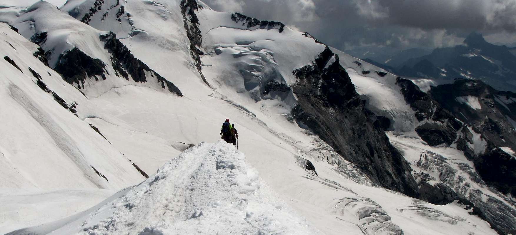
Elementary didactic and methodological instructions to face a Glacier
Not the glaciers always introduce him with impetuous falls, to manner of horrendous rivers frozen with towers of ice and hanging seracs and threatening men to arouse terror and in comparison to first sight; other times appear as whites and relaxed snowy blankets, giving entirely apparently the idea of a pacific and harmless expanse of snow harmless. Instead it is to hold well present that the danger hides him anywhere and, perhaps, mostly among these last that not among the first quoted, really because the factors of caution are inversely proportional, attention as well as vigilance. This explains the why of so many misfortunes happened entirely apparently in situations and in the place sure and absolutely not dangerous. The statistic and the historical search exactly point out instead the opposite one and they confirm the dangerousness of any glacier, also to put aside some quota, of the season, of the recent situation of cover with snow, of the conditions meteo and of visibility as well as of the factor wind. As Lorenzino Cosson (Courmayeur Mountain Guide) said that it is very difficult to die under an avalanche in the Lowland Padana, we am able a self-evident truth (or obvious De Lapalisse) to affirm that it is practically impossible to die in a crevasse in Plaza in the Vatican; but when a glacier is crossed instead no: the trap is possible on any of them, also on the smallest, forgotten and neglected; and the factor to have the skis cannot even exclude the event, for the qual thing, without exaggerating, it is better always to use the term to face that not that to cross a glacier. To the necessity we remember with some simple exemplifications that:
2) - that the famous Guide French Louis Lachenal disappeared with the skis to the feet in a longitudinal crevasse into Vallée Blanche in a harmless line apparently between the Aiguille de Midi and the Gros Rognon;
3) - of a collective fall of the School Gervasutti of Turin, led by the lamented Ribaldone, to the return from one first winter to the Mont Blanc du Tacul; luckily, being the crevasse of the type to U upset aloft, if they got by with some bruise.
These three examples, but they would be thousand other of it quotable, make to understand that the glacier can also strike the best and experienced of the mountain climber, the same good expert the "beast" e this without the need to trouble the great glaciers of the Himalaya!
 |
Insofar we allow us to look out upon some least instructions of base:
A) - Possibly not to face alone never a glacier and therefore untied remembering that the danger also exists going out of few meters of the footstep of base (recent deadly accident to the Breithorns).B) - to always Proceed in rope remembering that however the use of the rope results, if not used in correct way, a weapon to double cut because instead of a corpse he can realize two of them or also more because of the chain enthralling; to remember that the rope has to have a certain distance among the various components of the rope and has to be always in almost maximum tension, so that to grant space and time of reaction through the ice-axe to which it always owes to be anchored with a ring of rope on the same one or, and better, supplementary from which to be able then him to unhook after the arrest of the fall from a companion.
C) - Preferably to have the put on harpoons, since in case of fall you can be essential to try to go up again along the walls of the same crevasse (from personal and double almost simultaneous experience to the return from the Becca of Moncorvé toward the Standard Route of the "Granpa", 1967).
D) - to Have the gloves to avoid the awful attritions and relative scorches that the to flow some rope provokes.
E) - To have I set necessary garments to withstand waiting for a recovery and to have others of it backup in the backpack (the Mountain Guide Dayné died velocenente of hypothermia, in the time that the rescuers raced to give the alarm to the Village of Dégioz and the sudden paramedics they departed already finding him deceased).
F) - To have provisions and drinks in the backpack to withstand at least two days.
G) - To have with itself the instrument of the A.R.V.A. These least precautions can be fundamental to save you the life!
 |
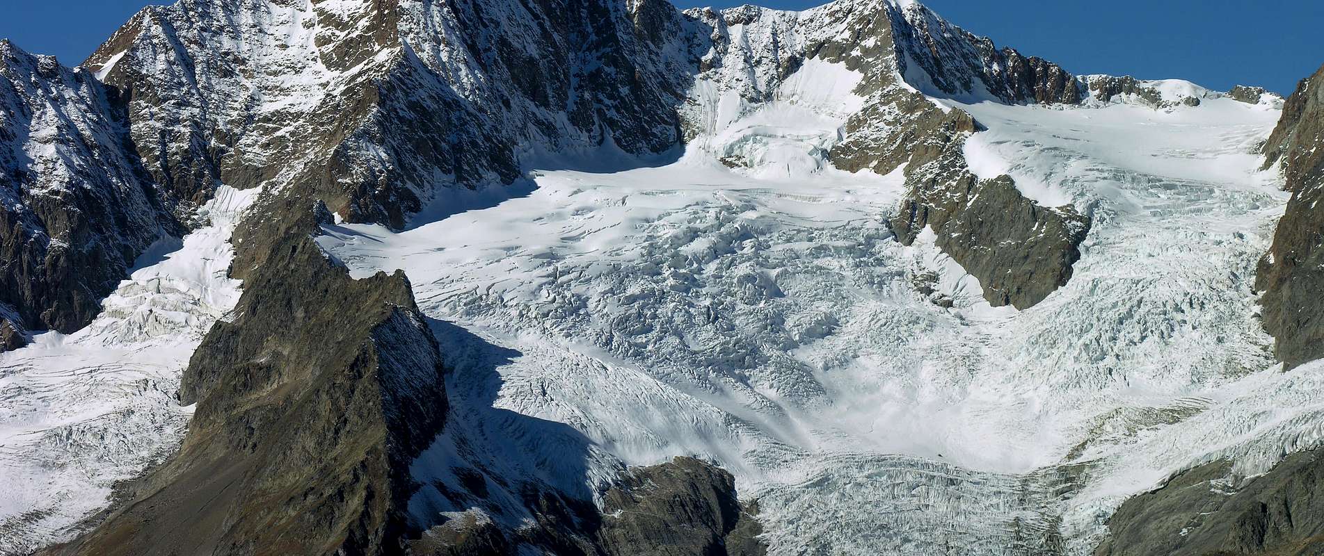
Some TERMINOLOGIES of the PHORMOLOGY of the CREVASSES
1) - Crevasse to form of V upset: hold or very narrow in surface it opens to form of cavern during the descent forming, but not necessarily, small formed narrowings, at times, from snowy balconies: very dangerous.2) - Crevasse to form of V upset: hold or very narrow in surface it opens to form of cavern during the descent with a dreadful abyss and with the ice that, to the sight, it changes the color in green, blue and an unfathomable terminal black (personal experience): really very very dangerous and generally lethal.3) - Crevasse to form of U, very wide in superficie and that it tightens him toward the fund: generally less dangerous in case of fall, but also less predictable in the individualization, since it involves an ampler sector of the glacier.4) - Crevasse type transversal: it is unfolded on the transverse axle in comparison to the rope that faces him in slope or in descent; in some situations it is to find effortless her with rapids chain succession, also with the distance of two meters one from the other (draws under les Aiguilles Grises on the Normal Via to the Mont Blanc).5) - Crevasse type longitudinal: prepared on the axle in the shape of arrow the respects to the sense of march; generally rarer, since the plasticity of the glacier has the tendency to break himself along the transverse axle of the same one.6) - Terminal "crepaccia" or bergsrunde: crevasse to the top of the glacial surface, where this goes to finish against the beginning of a wall. He can form some bridges of snow that allow the access the same one; the same can change and of very in the years (for instance to the Aiguille de Talèfre, where up to the Sixties the bridge of access in the Normal Street was to the right entirely situated (West; as from Guide C.AI./T.C.I. "Monte Bianco II°", 1968), while in the Eighties it was completely on the opposite side to around 300 meters distance.7) - Crevasse to form of letter hole: it is also found it where the glacial slant finishes against a crest rocky example Torre di Sant'Andrea to the Apostles into Gran Paradis Group, with personal experience of fall held back by the rope).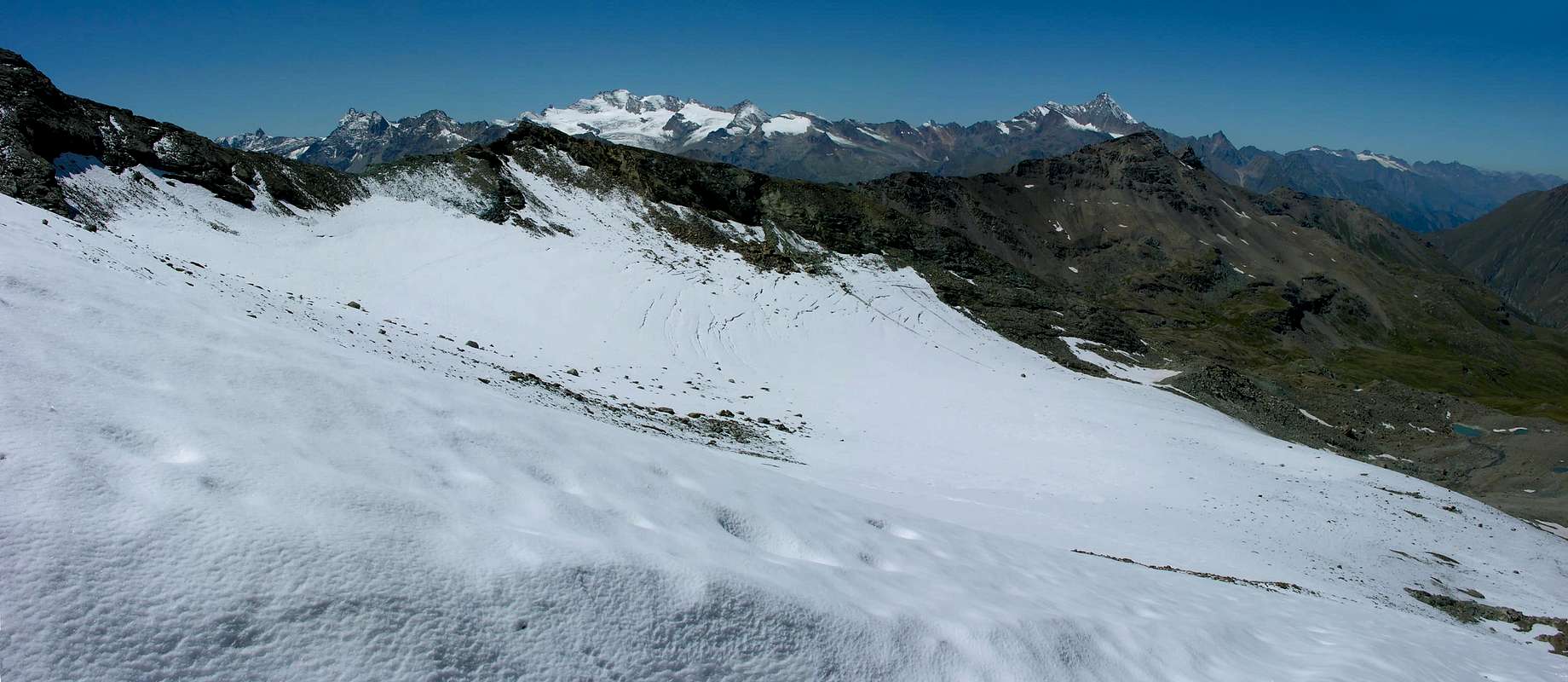 |
Elementari avvertenze didattiche e metodologiche per affrontare un Ghiacciaio
I ghiacciai non sempre si presentano con cascate impetuose, a guisa di orrendi fiumi congelati con torri di ghiaccio e seracchi penzolanti e minacciosi tali da incutere terrore e rispetto a prima vista; altre volte appaiono come bianche e rilassate coltri nevose, dando l'idea di una pacifica ed inoffensiva distesa di neve apparentemente del tutto innocua. Invece è da tenere ben presente che il pericolo si nasconde ovunque e, forse, maggiormente tra questi ultimi che non tra i primi citati, proprio perché sono inversamente proporzionali i fattori di cautela, attenzione, nonché di vigilanza. Ciò esplicita il perché di tante disgrazie avvenute in situazioni ed in località apparentemente del tutto sicure ed assolutamente non pericolose. La statistica e la ricerca storica invece indicano esattamente l'opposto e confermano la pericolosità di qualsiasi ghiacciaio, anche prescindendo dalla quota, dalla stagione, dall'innevamento recente, dalle condizioni meteo e di visibilità nonché dal fattore vento. Come diceva la Guida Alpina di Courmayeur Lorenzino Cosson che è molto difficile morire sotto una valanga in Pianura Padana, noi possiamo lapalissianamente e scontatamente affermare che è praticamente impossibile morire in un crepaccio in Piazza del Vaticano; ma quando si attraversa un ghiacciaio invece no: l'agguato è possibile su qualsiasi di essi, anche sui più minuscoli, dimenticati e negletti; e neppure il fattore di avere gli sci può escluderne l'evento, per la qual cosa, senza esagerare, è sempre meglio usare il termine di affrontare che non quello di attraversare un ghiacciaio. All'uopo ricordiamo con alcune semplici esemplificazioni che:
1) - la Guida di Valsavarenche Dayné morì a fine Ottocento, su di un percorso che lui conosceva come le sue tasche, appena dietro al Rifugio Emanuele II° alle propaggini estreme dei lembi glaciali del Ghiacciaio del Gran Paradiso, oggi ridotte a morena dal ritiro del medesimo ed all'inizio della Via Normale del Gran Paradiso;
2) - che la celebre Guida Francese Louis Lachenal sparì con gli sci ai piedi in una crepaccia longitudinale nella Vallée Blanche in un tratto apparentemente innocuo tra l'Aiguille de Midi ed il Gros Rognon;
3) - di una caduta collettiva della Scuola Gervasutti di Torino, capeggiata dal compianto Ribaldone, al ritorno da una prima invernale al Mont Blanc di Tacul; per fortuna, essendo la crepaccia del tipo ad U rovesciata in alto, se la cavarono con qualche ammaccatura.Questi tre esempi, ma ce ne sarebbero altre migliaia citabili, per fare comprendere che il ghiacciaio può colpire anche il più bravo ed esperto degli alpinisti, lo stesso miglior conoscitore della "bestia" e ciò senza il bisogno di scomodare i grandi ghiacciai dell'Himalaya!
 |
Pertanto ci permettiamo di prospettare alcune minimi istruzioni di base:
A) - Possibilmente non affrontare mai un ghiacciaio da soli e quindi slegati ricordando che il pericolo esiste anche uscendo di pochi metri dalla pista di base (recente incidente mortale ai Breithorn).B) - Procedere sempre in cordata ricordando che però l'uso della corda risulta, qualora non usata in modo corretto, un'arma a doppio taglio perché invece d'un morto ne può realizzare due od anche di più per via del trascinamento a catena; ricordare che la corda deve avere una certa distanza tra i vari componenti della cordata e deve essere sempre in quasi massima tensione, onde concedere spazio e tempo di reazione tramite la piccozza alla quale deve sempre essere ancorata con un'anello di corda sulla medesima oppure, e meglio, suppletivo dal quale potersi poi sganciare dopo l'arresto della caduta da parte di un compagno.
C) - Preferibilmente calzare i ramponi, poiché in caso di caduta possono essere essenziali per cercare di risalire lungo le pareti della stessa crepaccia (da personale e duplice quasi simultanea esperienza al ritorno dalla Becca di Moncorvé verso la Via Normale del Granpa, 1967).
D) - Avere i guanti per evitare i tremendi attriti e relative ustioni che lo scorrere della corda provoca.
E) - Avere addosso indumenti necessari a resistere in attesa di un recupero ed averne altri di riserva nello zaino (la Guida Dayné morì velocemente di ipotermia, nel tempo che i soccorritori corsero a dare l'allarme al Villaggio di Dégioz ed i repentini soccorsi partirono trovandolo già deceduto).
F) - Avere viveri e bevande nello zaino per resistere almeno due giorni.
G) - Avere con sé l'apparecchio dell'A.R.V.A. Queste minime precauzioni possono essere basilari per salvarvi la vita!
 |
Alcune TERMINOLOGIE della FORMOLOGIA delle CREPACCE
1) - Crepaccia a forma di V rovesciata: stretta o molto stretta in superficie si apre a forma di caverna durante la discesa formando, ma non necessariamente, piccole strozzature formate, a volte, da terrazzi nevosi: molto pericolosa.2) - Crepaccia a forma di V rovesciata: stretta o molto stretta in superficie si apre a forma di caverna durante la discesa con una voragine spaventosa e con il ghiaccio che, alla vista, cambia il colore in verde, blu ed un insondabile nero terminale (esperienza personale): veramente molto pericolosa ed in genere letale.
3) - Crepaccia a forma di U, molto larga in superficie e che si restringe verso il fondo: in genere meno pericolosa in caso di caduta, ma anche meno prevedibile nell'individuazione, poiché coinvolge un settore molto più ampio del ghiacciaio.
4) - Crepaccia di tipo trasversale: si dispiega sull'asse traverso rispetto alla cordata che l'affronta in salita o in discesa; in alcune situazioni è facile trovarla con rapida successione a catena, anche con la distanza di due metri una dall'altra (tratto sotto les Aiguilles Grises sulla Via Normale al Monte Bianco).
5) - Crepaccia di tipo longitudinale: disposta sull'asse sagittale rispetto al senso di marcia; in genere più rara, poiché la plasticità del ghiacciaio tende a spezzarsi lungo l'asse traverso del medesimo.
6) - Crepaccia terminale o bergsrunde: crepaccia al sommo della superficie glaciale, dove questa va a terminare contro l'inizio di una parete. Può formare dei ponti di neve che permettono l'accesso alla medesima; gli stessi possono cambiare e di molto negli anni (ad esempio all'Aiguille de Talèfre, dove fino agli anni Sessanta il ponte di accesso alla via normale era situato interamente a destra (Ovest; come da Guida C.A.I./T.C.I. "Monte Bianco II°", 1968), mentre negli anni Ottanta era completamente sul lato opposto a circa 300 metri di distanza.
7) - Crepaccia a forma di buca da lettera: la si trova anche dove il pendio glaciale termina contro una cresta rocciosa esempio Torre di Sant'Andrea agli Apostoli (Gran Paradiso), con esperienza personale di caduta trattenuta dalla corda).
 |
Essential BOOKS
"The Glaciers of the Alps", by John Tyndall. Edit. Murray, London, 1860.
"Les Alpes Occidentales", by Federico Sacco. Impr. du Col des Artig., Turin, 1913.
"Formazione dei serbatoi Montani. Considerazioni meteorologiche e geoidrologiche", by Federico Sacco. Borzoni e C., Torino 1918.
"Le Pays de la Doire et son Peuple" di Augusta Vittoria Cerutti, Musumeci Editeur, Juin 1995.
"Variazioni glaciali nel Gruppo del Monte Emilius"-"Glacials Variations in the Emilius Mountain Chain", by Alessandro Giusto Cardellina, pages various. Studies University of Turin, Mathematicals Faculty. Phisic and Natural Sciences/in Natural Sciences Course-Degree, Supervisor Prof. Michele Motta. One's thesis disputed in Turin, Apr 24th, 2009 (unpublished).
 |
External Links
FONDAZIONE MONTAGNA SICURA Villa Cameron, località Villard de la Palud 1 Courmayeur (AO) Tel: 39 0165 897602 - Fax: 39 0165 897647.
REGIONE AUTONOMA VALLE D'AOSTA the official site.