Most of Utah's hundred highest peaks are located in the Uintas, but 19 of them are scattered around the rest of the state. I had 12 peaks left and was looking for a change from the blood sucking little parasites of the Uintas. Belknap (12137') and Baldy (12122') seemed like a good choice as these were located in the southern part of the state and surely it would be drier down there. I had viewed these stark looking peaks from nearby Delano Peak in 2009. They looked more like huge tailings piles than mountains.
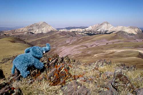
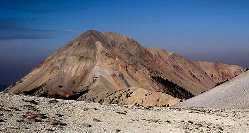
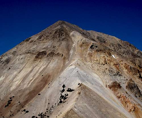
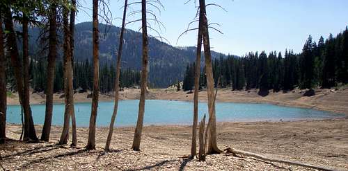
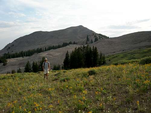
![Baldy and Belknap]() Baldy and Belknap from Delano, can you guess this was a family trip?
Baldy and Belknap from Delano, can you guess this was a family trip?
I checked daily for the opening of the access road and finally my husband (Joe) and I decided to go anyway and have a longer walk, but as luck would have it, it opened the day we left.
According to the Forest Service, you need a high clearance vehicle to get past the Skyline Trailhead. We don't have one. We'd drive as far as we could and then start walking. At most it would be an extra 2.3 miles one way to Mud Lake where we planned to start our loop hike which would include Belknap and Baldy, and a short side trip to point 11420. If we were up for it we'd also make our way to Shelly Baldy Peak (11321') at the end of the day.
To make the four hour drive more worthwhile, we planned to do an "easy" peak the day before and another the day after the big hike. Not being too familiar with that area and wanting something super short, the best I could come up with for our prehike hike was the unnamed dumpster diving peak, Point 8153, located just north of highway 153, on the road to Belknap and Baldy. It was only a 1453' vertical gain and by my planned all offtrail route, a mere 1.1 miles one way.
We didn't get started until 6PM and one half hour later had only made it .3 miles up the steep slope through thick scrub oak under a hot sun. Why oh why was I here and not at camp? All of tomorrow's energy was oozing from my body. It was hard to admit defeat, but at this rate it was stupid to continue. We toughed it out a little more and miraculously ran into an unofficial trail that we were able to follow until the brush thinned out. We made the summit, but didn't make it back to our car until 8:30PM.
We quickly drove to our turnoff onto the Beaver Creek Road and drove on it as far as Big John Flat where we sandwiched our tent in among some huge RVs that looked like they were there for the whole summer. I expected it to be noisy, but it was great, no one made a sound and I got a good nights sleep. Everything was fine, except for the cute little mouse in the corner of the bathroom. It looked like it was parked for the long haul and if I was to use the toilet, it would be within 2 feet of my ankle. Not liking that thought, I gave a big stomp and it ran out the door.
We were rummaging through our stuff, preparing for the next day, when I heard a loud "Oh no!!!". It sounded like the world was ending. Crap I thought, expecting some major blow to be announced like "I forgot my sleeping bag" or "I just cut my finger off". What I heard was "These aren't brown sugar cinnamon, these are chocolate fudge!" Joe's hiking food has consisted mainly of exactly one kind of pop-tart for the past 30 years and chocolate fudge was not it. I was glad it wasn't me who made the purchase. I was initially disappointed too, but chocolate fudge sounded kind of good and I looked forward to trying them.
We were on our way driving the next morning at 4:50AM. For the most part, the road was good and our Subaru had no problem. There was loose rock here and there, but nothing too bad. When we got to Poison Creek, we discovered that the creek just runs across the road. It didn't look too deep, but we still scraped bottom on the way over. The only real trouble was on a steep section where Joe stalled out and rolled backwards about 5 times before making it up. We did get to drive all the way to Mud Lake where we parked.
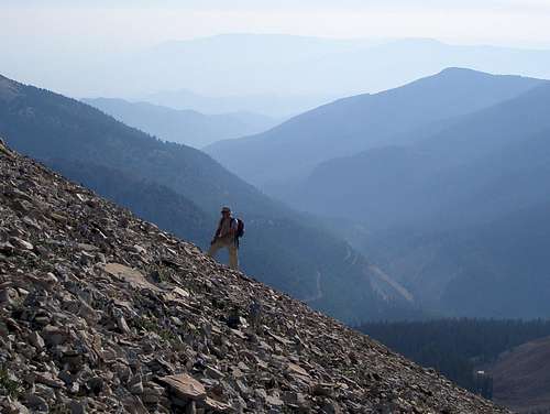
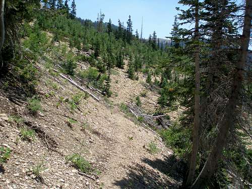
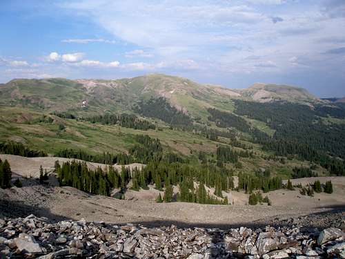
We started walking in the dark at 5:22 and walked the road 2.6 miles to the 10973 saddle, SSE of Belknap. There is a new bathroom there and an information sign. The depressing thing was that even though we had done a lot of uphill on the road, we had also done a lot of downhill and we were now lower than when we had started. Joe opted for a break and I ditched my pack and took an easy side trip southeast to the top of unnamed peak 11420. I had a good view of both the way we had come and the way we were going. Except at the very start, our route to Belknap looked totally barren and devoid of any vegetation.
![North ridge of Delano Peak]() The road we walked on goes in front of the pointy little bump in the center.
The road we walked on goes in front of the pointy little bump in the center.
![Mount Belknap]() Mount Belknap is left of center
Mount Belknap is left of center
We skirted most of the ridge on the way over to the base of Belknap. A good portion had a nice track through the scree. It would have been tough otherwise.
![Mount Belknap]() Almost to the base of Belknap
Almost to the base of Belknap![Mount Baldy]() Looking over at Baldy
Looking over at Baldy![Mount Belknap]() Huffin' and puffin' up Belknap
Huffin' and puffin' up Belknap
Hiking up Belknap's steep cone was annoying but doable, with much loose rock. My pack weighed a ton because on a recent trip we had both run out of food and water, and didn't want to repeat that experience. I looked over and noted that Joe was doing better than me. How could this be? He's a computer potato! I worked my way over to the line he was following and discovered that he had found a faint track through the scree and the going was much easier over there. I pulled ahead and the cosmic order was restored.
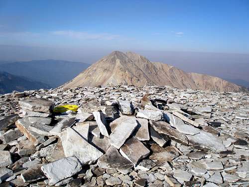
![Mount Baldy]() Looking at Baldy from the summit of Belknap
Looking at Baldy from the summit of Belknap
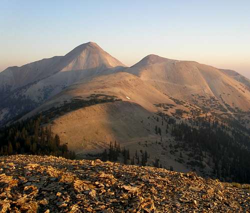
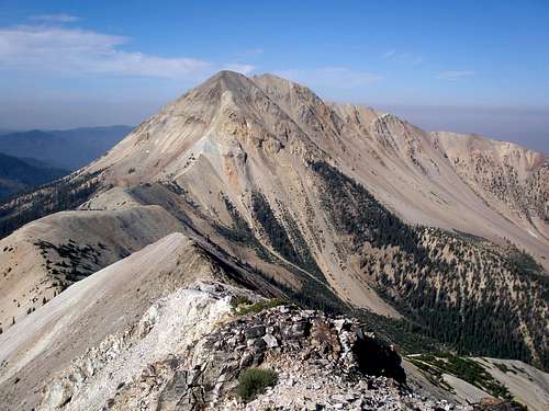
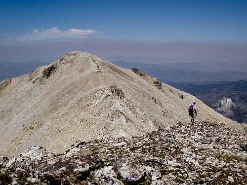
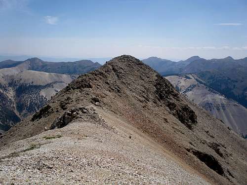
From Belknap, we traversed the ridge over to the base of Baldy. The ridge was a piece of cake compared to the steep climb up Belknap, but ahead Baldy was looming. Belknap had looked steep, Baldy looked impossible. If I hadn't known that other people had done it I would have said it couldn't be done by mere mortals.
![Mount Baldy]() The ridge to Baldy
The ridge to Baldy![Mount Baldy]() Baldy up close
Baldy up close
We got almost to the base and dumped everything we could by a small bush. It was super hot so I squeezed myself into the branches to take advantage of the meager shade. It was never hot like this at 12000' in the Uintas. I broke open a pack of the chocolate fudge pop-tarts and they tasted like dry cocoa powder straight from the can. It was hard to get them down, but I needed the calories.
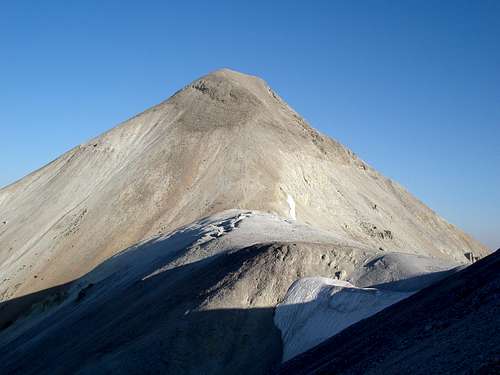
The bottom of the Baldy cone looked doable, and the top part didn't look too bad either, but the middle section looked pretty much vertical. In reality, it's about 45 degrees. It was tough getting up it, as it was all loose scree. You'd take a step up, and then slide back down to where you started. Fins of rock sticking up looked like solid holds, but were brittle and easily broke off.
![Mount Belknap]() Looking back at Belknap
Looking back at Belknap
I worked my way up the center and then angled to the right to a ridge coming in from the north. Once on the ridge, the going was easier and I knew we would make the top. I found a small flat spot and sat down and waited and waited and waited for Joe to show up. Even though he was just a few hundred feet away, I couldn't see him from where I was. I thought maybe I should get up and look over the edge, but I was safe where I was, and couldn't dislodge any rocks while I was sitting still. I figured that he wasn't dead because surely I would have heard him yell if he fell.
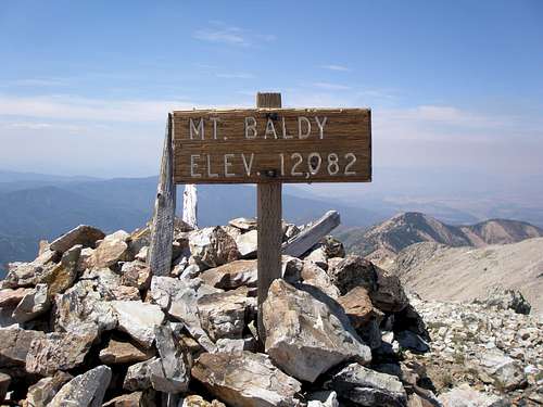
I sat there wondering how many people have climbed Baldy more than once. I for sure wasn't planning on coming back. Joe showed up unbloodied and we headed for the top. It was tough to get the summit mailbox open, but inside there were two registers filled with tons of names. I looked at a few and noticed one guy who had climbed it 13 times!
![Mount Baldy]() Baldy summit
Baldy summit
I had assumed that there was no doubt as to where the actual summit was, but unfortunately, a little to the west was another pesky summit and it was hard to tell by eyeballing it which was higher. My home printed map was pretty fuzzy so I couldn't tell from that either. I was virtually certain we were at the high point as it did have a sign, but virtually certain is not certain so of course we were going over to that one too. Joe showed up and wasn't too happy. He asked "Did you do your research?" I answered, "Obviously not enough". The other summit looked way, way, way, way far away, but in reality it was only .13 miles one way with about a 100' dip between the two.
![West summit of Mount Baldy]() Heading over
Heading over
![Mount Baldy]() Heading back
Heading back
After going over there and back, we had no doubts that we had been to the actual summit and started down. Down was a lot easier than up as gravity was in our favor. You could take a step and slide until you stopped and then take another step and slide. However, it was somewhat of a problem if one foot slid and the other one didn't. It was a relief to get down the steepest section and then back to our gear stash.
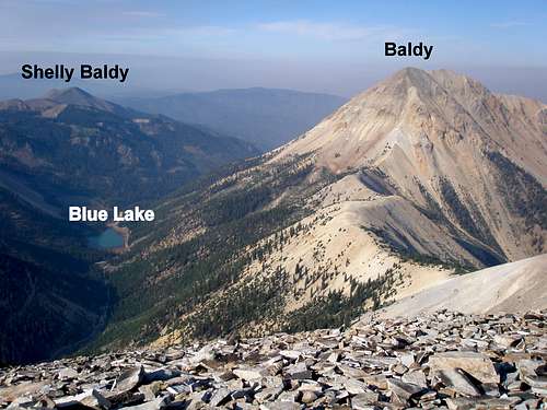
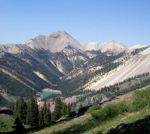
Most people who climb Belknap and Baldy park within a mile of Belknap and just do an out-and-back and don't do any road walking. I didn't think we could drive that far in our Subaru which is the main reason we opted for the longer loop from Mud Lake. The problem with the loop is that it is not just downhill to the car. There is a big hole aka Blue Lake (elev 9640') between the summit of Mount Baldy (12122') and Mud Lake (11000'). Also, we were still hoping to make it over to Shelly Baldy (11321').
![Mount Baldy]() The plan is to go over Baldy, down to Blue Lake, then on to Shelly Baldy.
The plan is to go over Baldy, down to Blue Lake, then on to Shelly Baldy.
To get to Blue Lake, we started back on the ridge to Belknap, but headed down the first spur ridge we came to. I was hoping for some nice dirt, but got a hillside full of boulders. Still, anything was easier than the scree on Baldy. Towards the bottom, the boulders turned into bushwhacking, but not too bad.
![Spur ridge]() Looking down our spur ridge
Looking down our spur ridge
![Mount Belknap]() Looking over at Belknap on our way down.
Looking over at Belknap on our way down.
![Blue Lake]() Blue Lake
Blue Lake
Down at the bottom was a dirt road that had not been on my map, leading to the lake. How fortuitous! We headed for the lake to find the trail that would bring us back to our car. It was supposed to loop around the north end of the lake, but the terrain was a muddy mess of downed trees and we couldn't find it. We were expecting something big and distinct since it was labeled a "National Recreation Trail" on the map. Joe had speculated that maybe it was an ATV trail. Doubts surfaced as to its existence and we weren't too happy, but we crossed to the far side of the lake and walked uphill perpendicular to the lake and voila! there it was. It was a mere foot path and not particularly wide. The trail was usually distinct, but not as well trod as expected. Occasionally we'd lose it and have to search for it. All in all, it did not meet my expectations for a nationally noted trail.
![The Skyline National Recreation Trail]() The Skyline National Recreation Trail
The Skyline National Recreation Trail![Mount Belknap]() Looking back at Belknap and Blue Lake
Looking back at Belknap and Blue Lake
We weren't in any hurry to make it back to the car. What was the point as we were camping another night? We could either hang out in RV land, or hang out on the trail. I was tired, my feet hurt, and it was hot. I think we took a break at every shady spot there was. Joe said "I've never seen you walk so slow." Shelly Baldy (11321') was still on the table, but didn't seem possible. We had barely climbed up five hundred feet from Blue Lake and would have over another eleven hundred for Shelly Baldy. Plus, we had to go over a bump to get there. Plus, it was off trail. I put off thinking about it until we arrived at the turnoff point. This spot was ideal because you couldn't actually see Shelly Baldy from there and you could optimistically imagine it to be easy. All you could see was the bump in between, a few hundred feet high which didn't look bad at all. We were at 10800' so it was just another 521' to Shelly Baldy plus whatever the bump was.
We turned off the trail, skirted the side of the 280' bump, and received our first close up view of Shelly Baldy. Joe said "This isn't what I was expecting." It wasn't what I was expecting either because what I was expecting was for Joe to start swearing when he saw how far away it looked. It was a long traverse with ups and downs through a rock field just to get to its base. The summit was still 3/4 mile away. First thing in the morning it would have been easy-peasy, but not so easy looking at the end of the day.
![Shelly Baldy Peak]() Shelly Baldy
Shelly Baldy
We trudged over a sea of rocks and started up the steep first 100'. Then it got more gentle and was just a slow slog to the top. The summit area had 4 large cairns and a rock wind shelter where I waited for Joe to show up. This was the only windy spot of the whole trip, but the walls weren't quite high enough to block all of it. I ate the last of my pop-tart crumbs and was looking forward to eating something without so much sugar back at camp.
![Shelly Baldy Peak]() Inside the rock shelter, too lazy to stand up and take a decent picture.
Inside the rock shelter, too lazy to stand up and take a decent picture.
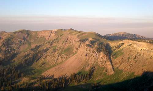
It would have been nice if it was all downhill on a nice trail to our car, but it wasn't. We descended to the base, trudged over a minor ridge, trudged through a rock field, trudged through a meadow, trudged up a hill, and finally connected with the trail. Delano Peak, the highpoint of Beaver County, was in full view. Even though it is higher than Belknap and Baldy, it looked green and lush as opposed to their stark appearance.
![Shelly Baldy Peak]() Almost back to the trail, looking back at Shelly Baldy
Almost back to the trail, looking back at Shelly Baldy
![Delano Peak]() Delano Peak
Delano Peak
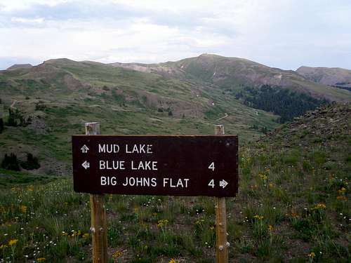
We did some more trudging along the trail and reached the intersection where a spur trail was supposed to take us back to our car. There was a big sign which directed us to Mud Lake. Unfortunately, the way to go was as clear as mud as we didn't see any trail in the direction it pointed. A minor amount of scouting revealed the trail and at last we were on the home stretch. I expected Mud Lake to be brown and muddy, but it was nice and clear, and there was our car on the other side. Yippee! It was 8:20 and we had been on the go for 15 hours.
![Mud Lake sign]() Mud Lake sign
Mud Lake sign
We drove back to the campsite, ate some soup, and cooked hot dogs at our absent RV neighbor's fire pit. The mouse was back in the bathroom, huddled in the corner. I didn't care. I was too tired to stomp and it looked pathetically scared. I ignored it, and it ignored me. I kept my mouth shut about hiking the next day, I kept it shut about what time to get up, I kept it shut about what time I was hoping to get home, and I kept it shut about every single little detail I'm usually obsessing about. Tomorrow was tomorrow but today was today.
I did wonder whether Joe was still interested in hiking the next day but figured I'd find out by observing his behavior in the morning. He got up and put his boots on, not his sneakers, so I figured we were going.
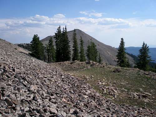
On the way back to highway 153 there is a very small "peak" named Sawmill Ridge. It only has 120' of prominence, but hey, it's only .36 miles from the road and only 600' up. We both have OCD, so we went for it. The bushwhacking was pretty annoying at first, but then it opened up and the rest of it was fine.
Next came our main hike of the day and last hike of the trip, Point 7805, which is located south of the Little Cottonwood Campground on Route 153. The map showed a trail 1.5 miles of the way followed by a .3 mile bushwhack. The problem was that we had scouted it out on the way in and didn't see any sign of a trailhead at the spot marked on the map. We were hoping we just hadn't looked hard enough because we were in a hurry. Hopes did not prevail and it remained an uneven gravelly area littered with slash and no sign of any trail and an annoying creek crossing.
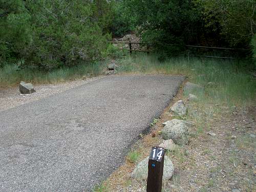
However, the map also showed another access point through the campground on the other side of the creek. We drove through the campground and at the far end where the trail was supposed to be, we found an occupied campsite (#14) with a big RV blocking any view of what was on the other side. We peered around it as best we could, but there was no hint of any trail and no parking except for the site occupants. Given that the other starting point didn't work out, we were pretty skeptical that there was a trail on the other side of the camper. If we knew for sure it was there, we would have quickly slunk by the camper, but we thought it would be kind of rude to just walk into someone's campsite and start rummaging around. Not being so emboldened, we drove back to the highway and parked so we wouldn't have to pay, and then walked back through the campground, and headed into the dense brush up a hill just before the campsite. After about 10 minutes of scouting, lo and behold, we found our trail and it turned out to be quite nice for a trail with no apparent beginning.
After about a mile we turned onto a side trail and made our way to a saddle. From here it was an easy bushwhack and I could already taste Dickies Barbeque where we were going to stop on the way home, but disaster struck and as Joe was bulldozing his way through a small brushy spot 10' from the top, he realized his glasses were missing and no he doesn't have a backup pair as these already were his backup pair. He lost his real glasses on a hike in February and six months later was still wearing his prescription sunglasses full time. He thought a branch might have caught them as he was pushing his way through and they had to be nearby, but wasn't sure. I thought they could be anyplace as frequently he hooks them over the front of his shirt and they could have fallen off at any point. I just didn't see how they could suddenly disappear from his face and he not know for sure, the instant they were gone.
They might be on the ground, they might be hung up on a branch, or when he threw some brush out of the way they might have gone flying too. We looked for 30 minutes and gave up, dejected and forlorn. He started walking and I was putting on my pack when he said "I found them." I thought he was joking, but there they were, right in the middle of a clear spot where we had both looked several times! It was about 15' behind the brushy spot he had been trying to get through. I was glad I wasn't going to be the only one doing the driving on the way home.
On the way back, we were curious about where the trail started so instead of doing the short bushwhack back to the campground, we followed the trail. It soon split, and one fork petered out as it approached the creek on the opposite side of where the trailhead symbol was on the map. The other fork did indeed lead to campsite #14 through a break in the fence. Fortunately, the RV had departed and we didn't have to intrude upon some stranger's family gathering.
![Well hidden trailhead]() Well hidden trailhead
Well hidden trailhead
We got to our car just as it started thundering and I was thankful that when we had done the long hike above treeline the previous day, it had been clear the whole time and we never had to worry about the weather. Now all we had to worry about was driving the 3 hours to Dickey's Barbeque Pit in Draper, chow down, and bring our teenagers some takeout. Unlike their parents, they both had actual paying jobs for the summer and couldn't come.
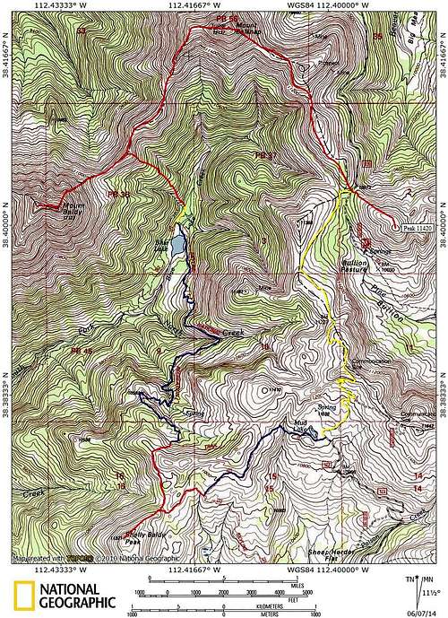
Trip topo
![Baldy Belknap topo]() Baldy-Belknap topo
Baldy-Belknap topo


Comments
Post a Comment