Mind
Last year I climbed my first mountain. The moderate, reliable talus slopes of Mount Woodring in the Tetons terrified this sport climber, used to crimping on nickel-edge rails that don't budge with your weight. Devastated I didn't enjoy mountaineering, but trying to humorously shrug it off, I called Mount Woodring, Mount Wouldn'tring...the next week my buddies wanted to climb the classic east face of Teewinot, and I replied, "More like Teewi-not in your lifetime!" Well, I did it, I hated it, and I started to love it. I loved doing something that I was totally uncomfortable with, and having that in-the-moment realization that I was overcoming personal fears and self-doubt. I was committed to becoming a mountaineer, despite the mental challenges I'd clearly have to wrestle with.
A year later and I'm addicted to peakbagging, and coming from a long-distance running background and a Mark Twight-esque light-is-right, every ounce counts ethic, I began tackling as much as I could with a 20-liter backpack and the Tetons in my backyard.
I quickly realized the beauty of other surrounding ranges (primarily the oh-so- remote Absorokas to the northeast and the Gros Ventres to the southeast) and wondered what was keeping me from exploring more terrain. The best way to do that, in my opinion, was to highpoint ranges, and what better way than summiting the state high point?
After a few months of tagging a dozen and a half summits in the surrounding area, building experience and calf muscles, and relentlessly researching, I began discussing Gannett with some of my more regular mountaineering partners. Maddie Casey, the Division 1 college swimmer, was up for anything, and proved it on any summit we tackled. Nathan Spearing, my fellow Indiana Hoosier turned Alaskan mountaineering guide, was also very interested. Joel Deblaay, overall superhuman, was out with a cliff-jumping related foot injury.
After a date was decided and anticipation was building, Nathan approached me in our Signal Mountain Lodge cafeteria and said he was no longer very committed...when I asked his reason, his reply was that "I didn't want to hike that far." Crap! How do you argue against that? He said there was one caveat...if we considered it in a single no-sleep push. I immediately hopped on board, since this fit in with my ethic anyhow...the approach is much longer than anything I'd done before, but I liked the leveled-up challenge.
We continued talking, and I suggested that on top of that, we do what seemed to be an obvious (but rarely done) thru-hike of the range, from the Dubois Glacier trail head and out the Pinedale Titcomb Basin/Pole Creek trail head. Maddie and Nathan were on board, and all we had to do was prepare, pack, and perform.
Body
After 6 hours of sleep and a 9.5 hour work shift, and some last minute prep, I hopped in my Mercury Villager, Vanna White, and we cruised the roughly 2 hours from our home base at Signal Mountain Lodge to the Glacier TH, arriving at 1030pm. Thanks to Joel, we had a shuttle to and from both trailheads, making the thru-hike possible. We gave him an estimated time of 27.5 hours, assuming 30 minutes a mile, and 30 minutes per 1000 feet of elevation gain. (Later I would realize this didn't take into account other important factors.)
We made good time through the night, stopping every hour for 5 minutes to stay hydrated and fueled. Nathan comically ate only Clif Shot Blocks, a packet an hour for the first six hours. Talkative and motivated, we made good time through the starlit windy night and only had routefinding issues at a three way split where the correct path went over a very established bridge that only went halfway over the flooded creek. We followed the creek upstream and the path picked up after a couple hundred feet.
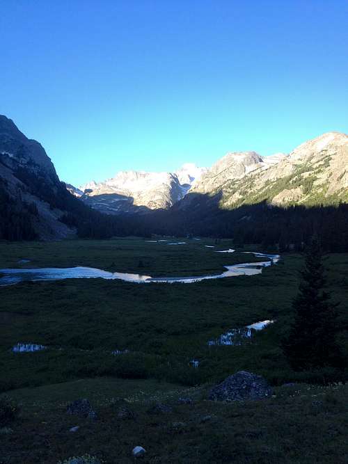
Passing through the swampy Big Meadows was a bit of a nuisance, due to losing the trail in the marshes. Our feet got soaked, and we just tromped straight through, aiming for the trees on the other side where the trail would pick up (as it did.) Hiking through Dinwoody Valley in sunrise was a stunning setting, one I'll never forget.
![Unnamed Image]() one of the first morning scenes we saw
one of the first morning scenes we saw
We lost the trail again about 22 miles in, where the trail goes over numerous stream crossings, and we stayed high and to the right. This was a mistake which set us back about 1.5 hours and several hundred feet of elevation gain and loss. Staying close to the river would've been the better option. We eventually saw the trail and headed down to gather water in the breathtaking river running through the valley. After bouldering hopping, lunch, and donning crampons, we left the base of the mountain and started moving up the Dinwoody Glacier right around 1230pm.
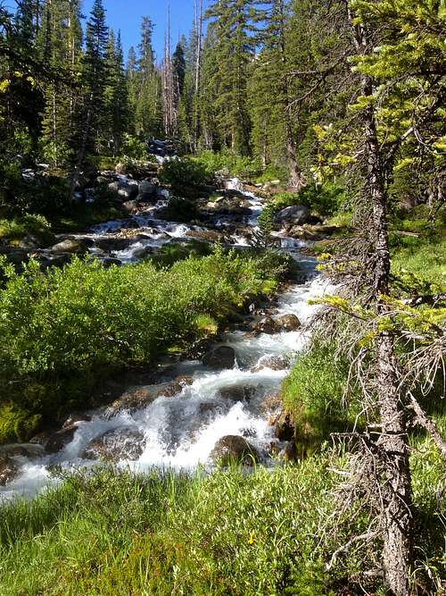
![Unnamed Image]() one of the many beautiful stream-fed areas
one of the many beautiful stream-fed areas![Unnamed Image]() early spot on Dinwoody Glacier
early spot on Dinwoody Glacier
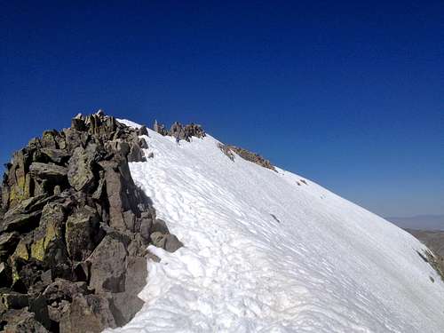
We were all feeling fresh and fine at this point, but being behind schedule due to a couple of routefinding issues and not including the break times (20 minutes for breakfast and 30 for lunch as well as all the 5ers every hour) was a bit discouraging. We took the standard route up Dinwoody and around Gooseneck Pinnacle, following the beaten tracks of the ones who'd gone before us.
![Unnamed Image]() traversing up one of the steeper sections
traversing up one of the steeper sections
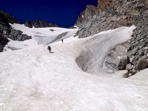
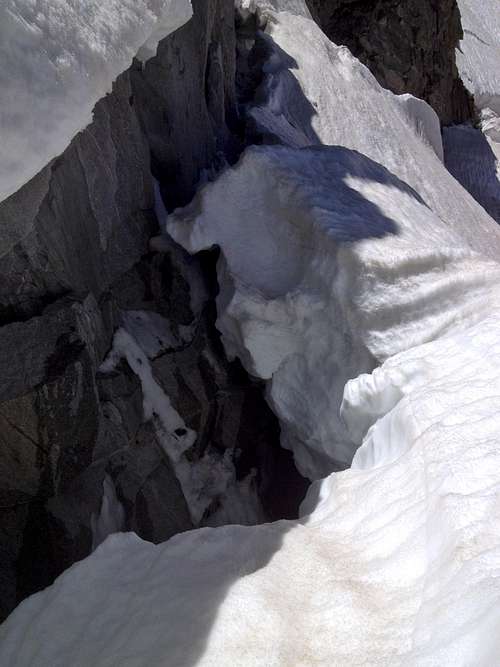
We could see the bergshrund starting to open up, and for some bizarre reason the ones before us traversed literally right up to it...well it was cool looking in, I suppose!
![Unnamed Image]() dat schrund tho!
dat schrund tho!
A few weeks ago, as we traveled up another peak, Nathan was reminiscing on all the gapers he saw on his trips up Rainier and Denali and stated exuberantly: "Dude! Anyone can climb a mountain! You gotta do it with class and style, dude!" This became a running joke, and keeping with this spirit, my first state high point, and making a good story great, I ran ahead of the other two out of site to a flatter area. I fished to the bottom of my pack and pulled out a long-sleeve button up shirt and a tie from a wedding I was in last year and donned them with my tights (anticipating winds on the summit ridge, but also to make the outfit more consistent, let's be honest.) I walked back to them over the glacier after putting my outfit and crampons back on and declared that famous line, "Dude! Anyone can climb a mountain! You gotta do it with style and class, dude!" Needless to say, they loved it.
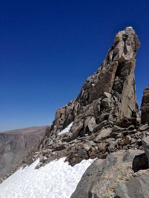
After a lot of upwards glacier travel we finally saw and passed Gooseneck Pinnacle, a bold and beautiful hunk of rock.
![Unnamed Image]() Gooseneck Pinnacle
Gooseneck Pinnacle
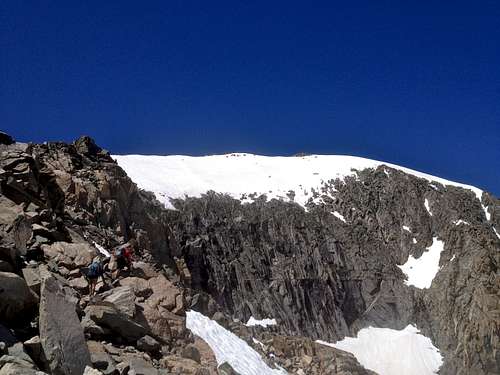
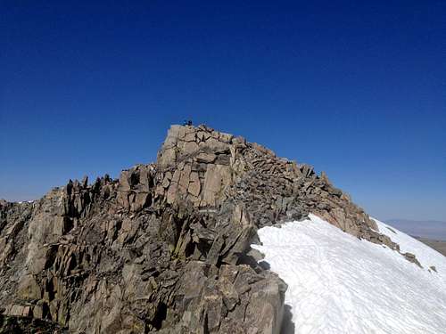
We all took our crampons off and started traversing up and over on the rock to gain the rock ridge, which we followed for what felt like ages.
![Unnamed Image]() Climbing rocks with the summit in the background
Climbing rocks with the summit in the background
At this point each of us were going through ups and downs in our energy level, and movement was much more tedious. We passed the only other people on the mountain at that time, a man from San Diego and another who had just completed Gannett as his 50th state highpoint. I congratulated him and asked him which was worst and he said this one! I told him I meant lamest and he said that Nebraska, Kansas and Delaware were all very lame.
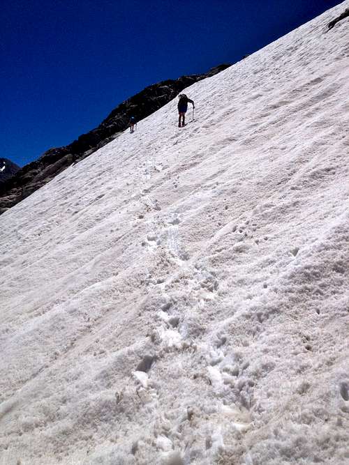
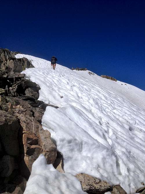
We put on our crampons to take the snowfield to the summit ridge after finding a small spring to gain water from. (Note: once you hit the glacier, there aren't really water refuel spots until after Bonney Pass. Gather enough, ration well, or lose ground going back down to the river.)
![Unnamed Image]() Maddie getting close to the summit ridge
Maddie getting close to the summit ridge
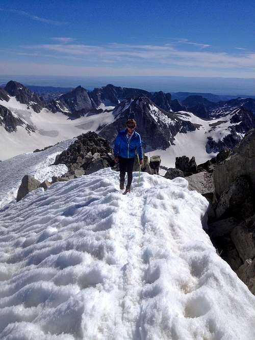
The summit ridge was one of, if not the most spectacular sections of mountain and views I have ever experienced in my life. The gothic cathedral 13ers to the south and the west (Bob's Tower, The Sphinx, etc), the wide open valley to the north, the glacial lakes below and the Tetons and Absorokas off in the distance gave you plenty to look at. The ridge was narrow with a super steep hanging snowfield that dropped off onto a massive cliff. Definitely a no fall zone! I committed to fully engaging the exposure and not just putting on horse blinders and "getting it done." It was well worth it and I felt more alive and in awe than ever.
![Unnamed Image]() the steeply sloping summit snowfield
the steeply sloping summit snowfield![Unnamed Image]() Moving up the summit ridge
Moving up the summit ridge
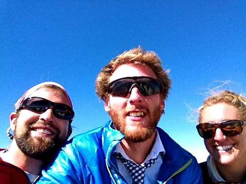
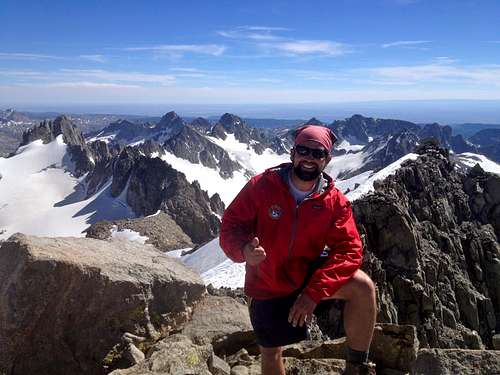
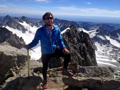
Soon, I was standing on the summit with my two close friends (with whom I had no issues, quibbles, qualms, or quirks with, unlike other SPers have had...) at 530 pm...a little later than expected!
![Unnamed Image]() Maddie and I on the summit block
Maddie and I on the summit block![Unnamed Image]() Nathan, me and Maddie with the summit selfie
Nathan, me and Maddie with the summit selfie![Unnamed Image]() Nathan with that summit stoke
Nathan with that summit stoke![Unnamed Image]() Me keeping mountaineering classy
Me keeping mountaineering classy
We didn't spend too much time, and made quick time descending all the way back down to the base. From here, we trekked south to Bonney Pass...that bitch. Slow going, exhaustion, and the sun were all setting in. We figured if we could make it to the top of the pass we'd be good, but then we peered down into beautiful Titcomb Basin and saw it was just covered with hard icy snow, and the 2200' pass was filled in with icy snow as well.
Will
After a quick meal break, we downclimbed the steep snow-turning-ice in the dark, afraid to slide into the rocks below. This brought me back to my first snowfield experience on Mt. Woodring, and I was reminded that no matter how much expertise and skill and gear one has, respect for the elements must always be in your packing list. From here we crossed snow, then marshes as we tried to find the trail in the dark. This took much longer than expected, and apparently, I was "emotionally compromised." I think I was just "befuddled." The mileage from the top of the pass didn't look nearly as far as it actually was, and it being 1130pm, I was just overly anxious to hit the trail and make swift progress. Nathan and Maddie were were both especially level headed about this, reasoning we were still paralleling a river and so we couldn't've hit the lakes yet. I was worried we were too high, and we were going to hit Mistake Lake (appropriately named, I figured), instead of the Titcomb Lakes and miss the trail altogether. Well, they were right, and we found the trail eventually, after plenty of vague social trails, boulder hopping, and plenty of marsh wading. We started moving very swiftly, and maintained this for about two hours, with each of us going in and out of feeling 100% to a full bonk.
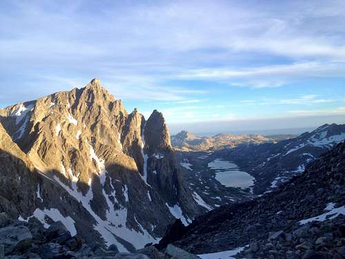
![Unnamed Image]() Titcomb Basin and Lakes from Bonney Pass
Titcomb Basin and Lakes from Bonney Pass
At this point, the last time I had refilled my 1 liter Nalgene was toward the top of Gannett, and I still had half the bottle. I also had two 160-calorie Kind bars...meaning I was dehydrated, very calorie-deficient, and hella tired (rookie mistake). I just kept fighting it off, because Shackleton could, and those two crazy dudes only took 20 GU packets when they did this same feat (I think that's the Gannett: The Hard Way trip report, which we relied on heavily. Thanks guys!) Hiking in the dark, I came to an unmarked split, both on trail and and map. I stayed close to the lake, thinking it may have been Island Lake. I was wrong. It was an unofficial camping area with trillions of minor trail splits which had us confused for what seemed like hours. I was literally hearing Ace of Base's I Saw the Sign and seeing signs for roads, fried chicken, and ice cream everywhere. I was not in a good state, but I shrugged it off cause I wanted to find my limits. Maddie was also tired, and beginning to be vocal about it. Nathan had maintained his pace and his nutrition very well (he being more experienced in long masochistic treks like this, and just being a smarter dude anyway), so he kept trucking in "4 wheel drive low." I was crashing...hard. Everyone was very discouraged KNOWING we were not only moving slowly, but in the wrong direction. At 230am, I declared what Maddie had suggested: we were taking a break to nap, and would routefind in the daytime. We collapsed under a tree, they with emergency blankets and me just being the big spoon. I was so exhausted I didn't even take my wet boots and socks off, despite having a dry pair in my pack. After three hours of freezing sleep and bizarre, lifelike hallucinatory dreams of restaurant waiters bringing us blankets and tea and sympathy, we awoke.
I still didn't feel like doing anything (yet another rookie mistake), so I didn't eat or drink. Nathan absolutely bossed the routefinding, and within ten minutes we were cruising the right trail next to glass-flat alpine lakes at sunrise, listening to birds and smacking the shit out of mosquitos. The whole area was absolutely stunning, and if not for that rest break, we wouldn't've seen it. After 1.5 hours of a pure death march, I asked to stop for water. I drank 1/4 of my Nalgene, refueled it, and pounded a Lara Bar and some GU. I was immediately amped and we made...decent time. We were all still going in and out of crashing and just operated on zombie autopilot. We finally made it to Photographers Point where we had a hilarious conversation explaining our trip to a family where they progressively realized how ambitious and ridiculous our trip was. From here, we took the flat trail for what seemed like eternity, pissed off that the beautifully flowered meadows were not parking lots with friends bearing a shuttle vehicle and Snickers bars. Finally, after miles of horse crap and flat monotonous, soul-deadening trail miles, we made it to the TH where our friends embraced us and an unimpressed man told us he did the same thing in 5 days from the Indian Reservation with horses portering his fucking gear. At least his dogs were friendly...
The wonderful Katie Brown played "In the Wind(s)" by Lord Huron, drove through Pinedale, and took us to the Wrangler Cafe where we demolished breakfast foods and then passed out for the next 30 hours...
Epilogue
This was an incredible trip for me...not just a good hike, not merely a fun climb, not a peak on a lot of lists, but truly a life-altering experience, because of the individuals involved, the logistics accomplished, and the personal limitations that were so drastically shoved further from my preconceived placement. The hike was neat, the mountain was forever memorable, but what I learned of myself was irreplaceable, and will set me up for an even more outrageous and daring type II-fun adventure for the future. (Kings-Emmons ridge traverse, here I come!)


Comments
Post a Comment