
-
 3047 Hits
-
 75.81% Score
-
 6 Votes
|
|
Mountain/Rock |
|---|---|
|
|
47.13444°N / 9.74199°E |
|
|
Hiking, Skiing |
|
|
Summer, Fall, Winter |
|
|
5935 ft / 1809 m |
|
|
Overview
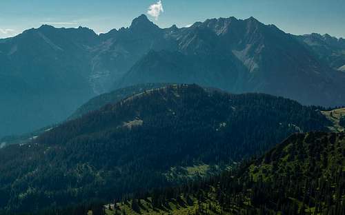 Loischkopf underneath the Zimba Group Loischkopf underneath the Zimba Group |
The Rätikon Range, which is located in the border region between Austria, Switzerland and Liechtenstein, is best known for the limestone mountains along its main ridge. There, the mountains almost reach 3000m (Schesaplana (2965m) or Panüeler Kopf (2859m)) but quickly elevations decrease as ridges head out towards the north and south, separating deep-set valleys. Between two of these, Brandnertal in the east and Gamperdonatal in the west, you will find the Fundlkopf Ridge, which runs south to north, steadily decreasing from Fundlkopf's 2401m to Mottaköpfle's 1221m. Near the end of that ridge you will find the ski areas of Brand and Bürserberg with the wide pastures of Parpfienz-Alm and Tschengla-Alm, above which three mountains rise: Mondspitze (1967m), Schillerkopf (2006m) and Loischkopf (1809m).
Being the lowest of the three, Loischkopf is the most visited mountain, especially in winter. A ski-lift ends to the north-east of its summit, so that it attracts most visitors during the ski season. In summer the dirt roads between the farm buildings on the pastures attract mountain bikers, many of whom take the short detour across the summit of Loischkopf. Hikers, on the other hand, appear to prefer Mondspitze and Schillerkopf, most likely due to their higher elevations and more exiting, though somewhat exposed, ascent routes.
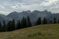 |  |  |
Loischkopf offers good, though not quite perfect views five valleys of the area. Most impressive presence is Zimba in the east with its signature limestone pyramid. To the south, above everything else, Schesaplana resides, from which the Fundlkopf-Ridge runs down to the Tschengla pasture. Deep down in the east you can see the city of Bludenz, above which Bregenzerwaldgebirge, Lechquellengebirge and Lechtal Alps can be seen.
If you can spare a long day, you can combine the hike to Loischkopf with the exposed hikes to Schillerkopf and Mondspitze. It is a most scenic tour, which nevertheless does not require too many skills or stamina.
Summit Panorama

Getting There
 Summit Panorama to the east
There are two trailheads for Loischkopf, one the cable-car from Brand to Eggen, the other Tschengla Alm, which is located above the village Bürserberg, itself at the mouth of Brandnertal Valley.
They are most easily reached by motorway A14, which connects Bregenz near Lake Constance with Innsbruck through the Arlberg Tunnel. Either of the ends of the motorway can be easily reached from Germany, Austria and Switzerland. Brand has an exit on the motorway and you have to go through Bürserberg to reach the village. In Bürserberg look out for signs to Tschengla, if you want to start there. There are several parking lots along the road and near the Tschengla holiday village. If you want to start in Brand, just stay on the road until you reach the cable-car.
Routes
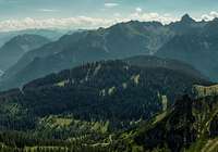
 The Zimba Group seen from the summit of Loischkopf
From the Brand Cable-Car
The route follows broad dirt roads, which connect the ski area around Brand with the one above Bürserberg. Overall the elevation gain is some 500m, the hiking time about two hours. Just follow the road from the cable-car to Parpfienz-Alm, a first of the farm builings on the wide pastures beneath Loischkopf. The route turns north-east onto Parpfienz-Weg, which leads to the second farm, Äußere Parpfienz-Alm. Here take the right hand road, which will take you to Klamper-Alm in a few minutes. Here turn northward onto one of the narrow ski-runs, which will take you to Loischkopf by passing in the west and heading for the Loischkopf ski-lift north-east of the summit. The final steps lead across meadows onto the summit.
From Tschengla-Alm
Start at the parking lot of the Loischkopf ski-lift. Here a dirt road starts, which negotiates the Loischkopf north-eastern slopes, crossing the ski-runs several times. It heads to the north of the mountain, joining the Brand-Route about 150m from the summit. Turn left (east onto the route until you reach the ski-lift. From there cross the summit meadows to the top. elevation gain is 700m, duration 2h.
Mondspitze, Schillerkopf and Loischkopf
From Tschengla-Alm you can start a 7h, 1200m elevation gain hike to the three summits of Mondspitze, Schillerkopf and Loischkopf. It is a nice and very scenic round-trip, which will be described in a separate route page.
Red Tape
 Papillo machaon
There is no red tape here. As you'll have to cross the pastures of Tschengla Alm and Rona Alpe, please make ssure to close all gates and (electrical) fences behind you. There are a lot of orchids on the upper parts of the routes (mainly gymnadenia conopsea), which are strictly protected. Leave them where they belong!
Accommodation
Since Brandnertal is a well known ski area there is plenty of accommodation nearby. You can use the following link:www.brandnertal.at
Also, in Bürserberg, beneath Tschengla Alm, there is a campground if you are inclined this way.
Weather Conditions
Webcam on the top of Loischkopf
Maps & Books
Maps
- Brandnertal / Nenzinger Himmel / Rätikon
1 : 35.000
WK 5374
Verlag Freytag & Berndt
ISBN: 978-3-7079-1275-3
- Montafon
1:25000
WK 032
Kompass Verlag
ISBN: 978-3-85491-614-7
Books
- Brandnertal
Herbert Mayr
Rother Verlag
ISBN: 978-3-7633-4035-4