
-
 10332 Hits
-
 87.76% Score
-
 25 Votes
|
|
Route |
|---|---|
|
|
45.90771°N / 7.86069°E |
|
|
Mountaineering |
|
|
Summer |
|
|
Half a day |
|
|
Alpine F |
|
|
Overview
Piramide Vincent NW Normal route
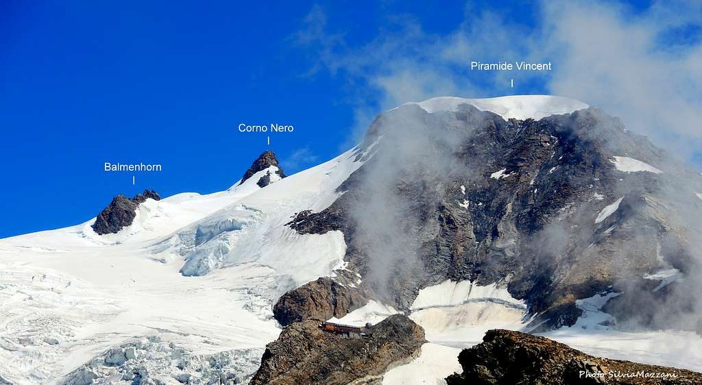
Piramide Vincent 4215 m is a mountain belonging to Monte Rosa Group, Pennine Alps and located between Punta Giordani and Colle Vincent. It's entirely located in Italian territory, shared by the regions of Valle d'Aosta and Piemonte and it's the last peak on the majestic and long ridge starting from Punta Nordend and winding from North to South with a terrific sequence of 4000s: Dufour, Zumstein, Gnifetti, Parrot, Ludwigshöhe, Corno Nero are the other peaks that make up this extraordinary icy and rocky wall. Piramide Vincent is one of the easiest 4000s of the Alps, together with Western Breithorn and - as its name tells - it's a true pyramid with four ridges that give rise to as many sides.

The peak took its name from the first climber, Johann Nicolas Vincent from Gressoney, who summited in the summer of 1819 along the South-East route. In the next chapters it will be described the route rising along the North-West slope, which is currently the Normal route to climb the mountain.
 seen from the west")

Getting there
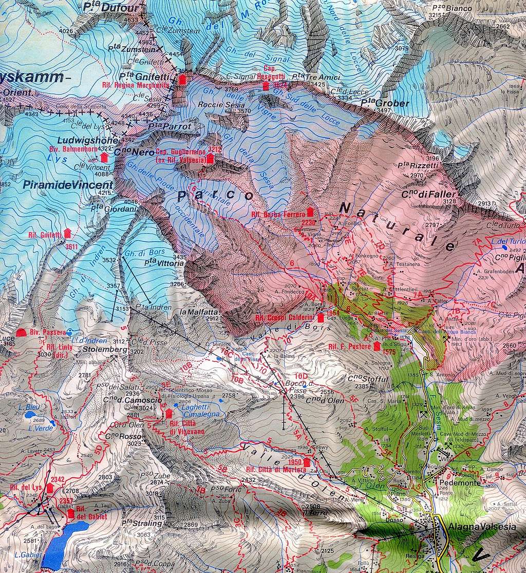
Two different road approachs are possible depending if coming from the Valle di Gressoney (Aosta) or from Val Sesia
Access via the Valle di Gressoney (Aosta Valley) - From the A5 Torino – Aosta Highway, exit to Pont St. Martin and take the Valle di Gressoney, getting to Gressoney St. Jean, Gressoney La Trinité and Staffal. From Staffal take the Cable car to Alpe Gabiet – Passo dei Salati - Indren


Access via the Val Sesia (Piedmont)
- From the A26 Highway exit to Romagnano Sesia and take the road to Varallo Sesia. Here continue following all the Val Sesia road to Alagna Valsesia. In Alagna Valsesia take the Cable car to Pianalunga - Passo dei Salati – Indren Access to the Rif. Città di Mantova 3498 m or Rif. Gnifetti 3611 m Get to the Rif. Gnifetti from Punta Indren, 3260 m (cable car from Alagna or Gressoney) in 1,5 h via the Rif. Città di Mantova, 1 h to Rif. Città di Mantova. In the lower part, it is a marked path (n. 5). The traverse of the glacier is not marked. From Punta Indren, traverse the ski-run, slowly going up on the Indrenglacier till you reach the outstanding rock band above which the Mantova-hut is situated (yellow-red signs). You climb up the rock steps (fixed ropes). To reach the Gnifetti Hut from the Mantova Hut you have to cross the glacier going up over the E-side of the glacier to the N and at the end on the rocks to the Gnifetti hut. This will take up to 30 minutes longer.
Route description
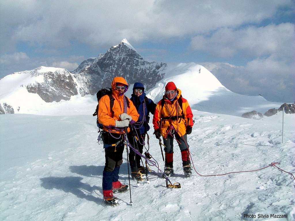
Piramide Vincent North West side (Normal route)
Difficulty: F (Alpine scale)
Difference in level: 600 m from Capanna Gnifetti - 750 m from Rifugio Mantova
An interesting route, following at first a great glacier – the Lys Glacier - then the gentle NW slopes of the peak. The ascent is easy, but involving a complete glacier's equipment. Lys Glacier has several crevasses - often hidden in the early summer - so it is necessary to cross it proceeding enroped.


Route report
From the shelters – Rifugio Mantova or Capanna Gnifetti – gain the starting point of the Lys Glacier. Enter the glacier and follow it at first to North East, then to North, rising along gentle angled ice-slopes. Continue always along the track heading the Lys Col. After a main level section, climb a steepest section and at about the height of 4000 meters, almost under the rock of Balmenhorn, turns sharply to the right in the direction of the Col Vincent without reaching this latter. Follow an obvious track generally present in summer up the North-West slopes of Piramide Vincent getting the wide summit.

Descent: the descent is done reversing the same itinerary.
Essential gear
Rope, axe and crampons
Red tape
There are no particular permits required to climb the peak.
Huts

- Rifugio Città di Mantova m. 3470
Situation: Garstelet Glacier Open: from June to September Size: 85 persons + 15 in the winter-shelter Guardian: Guide di Gressoney Hut's phone : 0039 0163 78150 / 347 0802910 Email: info@rifugiomantova.it

- Capanna Gnifetti m. 3611
Situation: Garstelet Glacier Open: spring from middle March to middle May - summer from middle June to middle September Size: 176 persons + 4 in the winter-shelter Hut's phone : 0163 78150 / 347 0802910 Email: info@rifugimonterosa.it
When to climb
Best months are June, July, August and September. Ski-mountaineering: from the end of March to the end of May
Guidebooks and maps

 Guidebook")

- Guidebooks
"Il grande libro dei 4000 - Vie normali e classiche" by Marco Romelli, Valentino Cividini - Idea Montagna Editore, 2015
“Tutti i 4000 – L’aria sottile dell’alta quota” – Club 4000, CAI Torino – Vivalda Editori
“4000 delle Alpi” by Richard Goedeke - Ed. Libris
“Monte Rosa” by Gino Buscaini - Guida dei Monti d'Italia C.A.I.-T.C.I.
- Maps
"Breuil/Cervinia-Zermatt" Kompass map 1:50.000.
"Cervino-Matterhorn e Monte Rosa" n. 5 - Istituto Geografico Centrale map 1:50.000