
-
 3214 Hits
-
 75.81% Score
-
 6 Votes
|
|
Mountain/Rock |
|---|---|
|
|
42.27585°N / 9.07329°E |
|
|
Hiking |
|
|
Spring, Summer, Fall |
|
|
5791 ft / 1765 m |
|
|
Overview
 Dome landscape near the summit of Le Forcelle Dome landscape near the summit of Le Forcelle |
Most of Corsica's most important mountains, most of its 2000ers are located on the s-shaped backbone crest, which wriggles from the north-west of the island to its south-east. There are only a handfull of road passes across this range but there is a multitude of narrow valleys which run in towards the very bases of the mountains, often forming narrow gorges with walls rising up several of hundreds of metres.
Two of these gorges, two of the most famous ones, Gorges de la Restonica and Gorges de Tavignano, lie back to back to each other, only separated by an west-to-east running ridge. Both canyons start a few hundred metres apart on the outskirts of Corte, and end beneath the central 2000ers in the west, still less than 2km apart from each other. The separating ridge, which runs away from the s-shaped backbone is home to some of the best lookout peaks of the area, even though it doe not reach overly impressive heights.
 |  |  |
One of these lookout mountains is called Le Forcelle, or is it rather the multitude of passes and saddles between its many summits, that are denoted by the name? The mountain consists of many granite domes, which - typical for Corsica - are made up from red and grey granite. Many of them show the erosion forms, which are called Tafoni on Corsica, bizarre structures taking every conceivable form, often with caves and overhangs. Here on Le Forcelle, the round-topped domes dominate with only few caves and caverns.
 |  |  |  |
The domes are located on steeply sloped terrain and require a bit of scrambling to be reached. They are small, only few of them reach more than 50 wall height from the valley side. Yet to reach their tops requires climbing skills. The highest point, however, can be reached by a hiking trail and only the final 20m require some UIAA I climbing / scrambling. From the top you realize that Le Forcelle surpass the accompanying ridge, which is wide and plateau-like (Plateau d'Alzo) in this place, by less than 100m. Still the mountains offers views of all Corsicas highest mountains, from Monte Cinto, to Paglia Orba, from Pic Lombarduccio to Monte Rotondo.
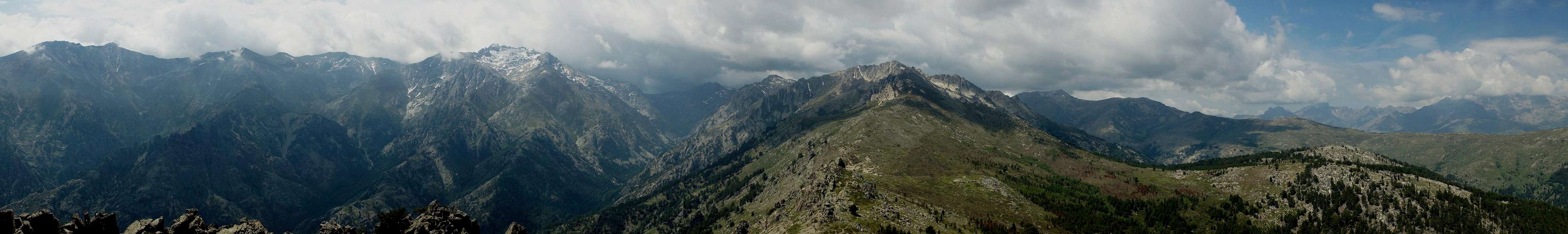
Summit Panorama
  |
Getting There
 Pic Lombarduccio above Gorges de la Restonica
Corsica can be reached by ferry or by plane. Major gateways are Ajaccio in the west and Bastia in the north. Usually both ferries and planes start from Marseille or Nice on the Côte d'Azur.
There is only one reasonable trailhead for Le Forcelle, which is inside Gorges de la Restonica. There iis an option to hike out Gorges de Tavignano from Corte, then ascend to the mountain and descend to Gorges de la Restonica. However the 10km+ road hike back to Corte will deter everybody but the mostt determined hikers.
Restonica Gorge
The gorge is one of the major climbing centers in Corsica. You reach the gorge either from Ajaccio in the west or Bastia in the north by taking RN 193 to Corte. There turn into D623 which immediately leads into the gorge. 10km behind Corte, about 500m before you reach the the bridge Pont de Timozzo, in a left bend of the road, the path turns off to the right. If you don't have a car, two options are the shuttle bus from Corte and (especially off-season) taxi from Corte, which costs about 30 EUR.
Red Tape
 Pancracium Illyricum
There's no red tape here, though lots of cattle and sheep graze on plateau d'Alzo. If you are lucky and the cabins on top of the plateau are inhabited you cen get some of the faous Corsican cheese there.
Accommodation
It's getting more and more easy to find accomodation on Corsica. However, most of the hotels or holiday apartments as well as campgrounds are located on the coasts. In the villages along RN 193 you'll find occasional inns and hostels and at Corte and Vizzavona there are hotels.As for camping there are two campgrounds in Corte, at the mouth of Gorges de la Restonica:
Weather Conditions
 Le Forcelle seen during the descent
Weather quickly changes on Corsica, especially in the mountains and even more especially near the passes through which fierce winds blow almost every day. Quite often a perfect morning will turn into fog around noontime but settle to calm weather in the late afternoon. Temperatures on the mountains are often less than what you would expect when starting from the valleys or the coast.
Maps & Books
Maps
- Corte / Monte Cinto
1 : 25.000
Carte de Randonnée 4250 OT
ISBN: 978-21142500386
Books
There are quite naturally quite a number of guidebooks, most of them in French. I found the following as good as could be expected:
- Corsica (Corse / Korsika)
Klaus Wolfsperger
Rother Verlag
ISBN: 978-3-7633-4819-0 (English)
ISBN: 978-3-7633-4907-4 (French)
ISBN: 978-3-7633-4280-8 (German)