
-
 5258 Hits
-
 82.48% Score
-
 15 Votes
|
|
Mountain/Rock |
|---|---|
|
|
46.88935°N / 10.37545°E |
|
|
Hiking, Scrambling, Skiing |
|
|
Summer, Fall, Winter |
|
|
9902 ft / 3018 m |
|
|
Overview
 Piz Nair seen from the first foresummit to its south Piz Nair seen from the first foresummit to its south |
Piz Nair means "black peak" and it is a very common name in Switzerland's Canton Graubünden / Grischun / Grison. There is hardly a mountain group in the area, in which a Piz Nair is missing and there are some groups where you can find several of them. The mountain described on this page is located to the south of the Samnaun Group, among the highest mountains of the group.
Named the Muttler Subgroup after Samnaun's highest mountain Muttler, in this group, basically a west-to east running ridge, you can find most of Samnaun's 3000ers lined up beside each other. It culminates in two mountains of nearly equal height, Stammerspitz / Piz Tschütta (3254m) and aforementioned Muttler (3294m). Between these two mountains, placed a bit to the south of them you can find Piz Nair.
 |  |  |
In itself, Piz Nair is certainly not a popular mountain. Even though it commands wonderful views (just compare the pictures on this page) it is overshadowed by its heigher neighbours. Also the closest trailhead at the hamlet Vna is located at 1450m, so that you will have to scale some 1700m until you reach the summit. Made up from a brittle mixture of gneiss and schist Piz Nair doesn't look overly inviting and most visitors to the area turn around on Piz Arina even though it is roughly 200m lower.
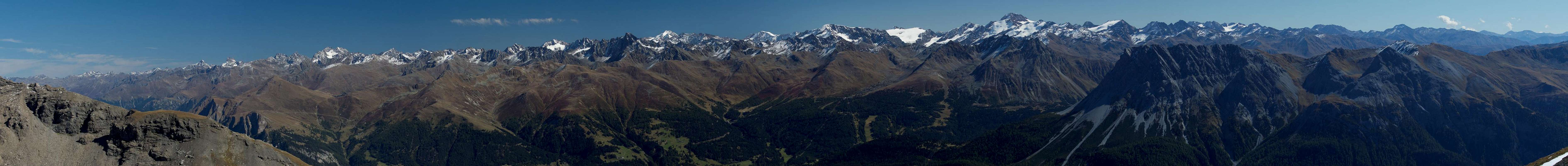
On the other hand - while there is a route to Muttler from the south, it scales even more elevation so that the next bes thing is to head for Piz Nair. Apart from the close-up views to Stamerspitz / Piz Tschütta and Muttler you will be able to admire a panorama which stretchesfrom the Ötztal Alps in the east across Sesvenna, Ortler and Bernina Groups in the south towards the Albula Alps and Silvretta Group in the west. On a fine day you will find it hard to leave the summit.
 Bernina Group Bernina Group | ||
 Ortler Ortler |  Cevedale Cevedale |  Watzespitze Watzespitze |
 Wildspitze Wildspitze |  Weißkugel Weißkugel |  Rabenkopf Rabenkopf |
 Fluchthörner Fluchthörner |  Piz Tasna Piz Tasna |  Krone Krone |
As for the route, it is rather straightforward until you reach an elevation of 2900m. You can pass a steep section so that you'll reach 2950m without problems. Only the last 50m require some routefinding and easy climbing experience. The summit cone ismade up from brittle blocks and you have to tread carefully not to dislocate any of them.
Summit Panorama
  |
Getting There
The best trailhead for Piz Nair is located in the hamlet Vna in Unterengadin. It can be reached from B27 by turning north through Ramosch.From Switzerland:
- Take motorways A3 and A13 to Landquart
- Switch to B28 across Flüelapass to Susch
- In Susch turn onto B27 to Ramosch.
From Austria:
- Take motorway A12 to Landeck
- Switch to B180 to Pfunds
- A bit after the village switch to B184, which turns into B27 after you cross the Swiss - Austrian border
- At Ramosch drive through the village to reach Vna
From Italy:
- Take motorway A22 to Bozen / Bolzano
- Switch to SS38, passing Meran / Merano to Prad / Prado
- Turn onto SS40 to Reschenpass / Passo di Reisa
- Cross the Austrian border an take B180 to Nauders.
- At Nauders turn onto B185 to Martina.
- After crossing the Swiss border turn onto B27 to Ramosch from where you get to Vna
Route
 |
There are two possible routes which in general are usually hiked or skied to reach Piz Arina (2828m). As you start from roughly 1450m this is already quite an achievement. Piz Nair is 200m higher and located to the north of Piz Arina. It can be reached by hiking its south ridge.
The routes pass Piz Arina to its western or eastern sides. The western route runs out Val Sinestra from Vna to Alp Pradatsch, where it directly heads for the summit of Piz Arina. From here descend along the north ridge towards Fuorcla Pradatsch. The eastern route heads for Alp Discholas from where a wide circle takes you to Fuorcla Pradatsch.
From the saddle head up the south ridge of Piz Nair. The ridge is broad but turns very steep midway. After a short rocky section you'll step on a fore-summit with a large cairn (2870m). After descending a few metres towards a saddle, the real ascent of Piz Nair starts. Insted of hiking the direct ridge turn westward to avoid the steepest section with a second foresummit. Pass it instead and head for the following saddle, from where a short ascent leads to a long stretched ridge (third foresummit). After another shallow saddle head up the summit of Piz Nair along its west ridge.
Red Tape
There's no red tape here. You are in the border region between three countries (Italy, Switzerland, Ausria) so make sure you have an ID with you.When to Climb
 |
Best time for climbing Piz Nair is autumn (September and early October. It is possible to do a ski tour in Winter. Make sure you use the eastern route as the western one can be prone to avalanches. Also, you might be forced to stop on the first foresummit due to avalanche danger.
Accommodation
Weather Conditions
Maps & Books
Maps
- Digital Maps
- Regular Maps
- Unterengadin-Nationalpark
Kompass Map WK 98
1:50.000
ISBN: 3-85491-331-1
- Nationalpark Zernez,
Swisstopo Map 459T
1:50000
ISBN: 978-9602125731
- Samnaun
Swisstopo Map 1179
1:25000
ISBN: 978-9602122112
- Unterengadin-Nationalpark
Books
- Unterengadin
- Samnaungruppe
Paul Werner / Ludwig Thoma
Alpenvereinsführer
Rother Verlag
ISBN 3-7633-1241-2
Rudolf Weiss / Siegrun Weiss
Rother Verlag
ISBN: 3-7633-4043-2