
|
|
Mountain/Rock |
|---|---|
|
|
39.67538°N / 119.67452°W |
|
|
Washoe |
|
|
Hiking |
|
|
Spring, Summer, Fall, Winter |
|
|
5292 ft / 1613 m |
|
|
Overview
There are many mountains named Sugarloaf throughout the USA. Sugarloaf Peak in Spanish Springs, Nevada is one of them. Like many other mountains with the same name, Sugarloaf Peak is a conical hill rising straight up from the valley. It is steep on all sides. Its actual prominence is 375’.While not spectacular by any means, there are some pretty excellent views due to its location in a valley. However, it can technically be considered part of the Pah Rah Range because of its proximity to the range and its saddle being higher than the underlying valleys that separates the Pah Rah Range from other mountain ridges.
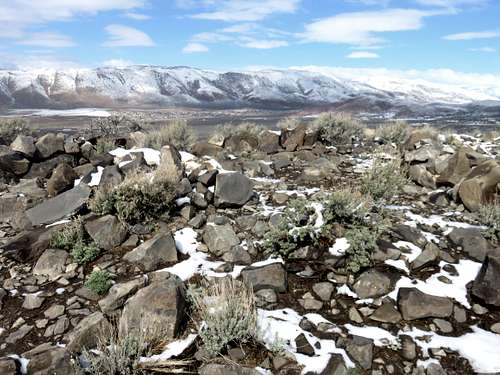
View northwest from the summit towards the Hungry Ridge
The reason Sugarloaf deserves any mention, is because despite the burgeoning home building in the area, a path has been created specifically to provide access to mountain bikers, hikers, and trail runners to reach the summit. This dedicated path (a beneficiary of a federal grant in 2011 to keep it clear and add trail signs) was intended to preserve land around the mountain for recreation. The result is that Sugarloaf will be a frequent destination for residents of Northern Nevada going forward, especially as new home building occurs.
Sugarloaf Peak can essentially be hiked any time of year. However, summers are typically pretty hot, and if hiking here during the summer, it is recommended early in the morning or during the evening. It is an excellent spot to watch the sunset.
Getting There
There are three starting points for Sugarloaf. All require driving up Highway 445 – the Pyramid Highway. From I-80 take exit 18 and drive north for about 10 miles.The standard route with a dedicated trail is actually the longest. It is ideal for trail runners, mountain bikers, or just people interested in a leisurely stroll. For the standard route, do not take Calle De La Plate. Instead continue for another three-quarters of a mile north on Pyramid Highway and turn right on Horizon View Avenue. Then take your first right on Paradise View Drive. At the end of the road is a circle and a trail sign.
There are two starting points off of Calle De La Plata which provide much shorter approaches. For these starting points, take a right on Calle De La Plata.
About 1.5 miles up the road there is an open space at about 39.66834, -119.6751. If you park on the right side of the road, and cross the street, you can head right up to Sugarloaf Peak.
Another approach is from the northeast. Take Calle De La Plata for about three miles. The road turns back to the west and becomes Capistrano Drive. Take Capistrano Drive downhill to the end and park at a circle. It is right at the edge of Sugarloaf Peak.
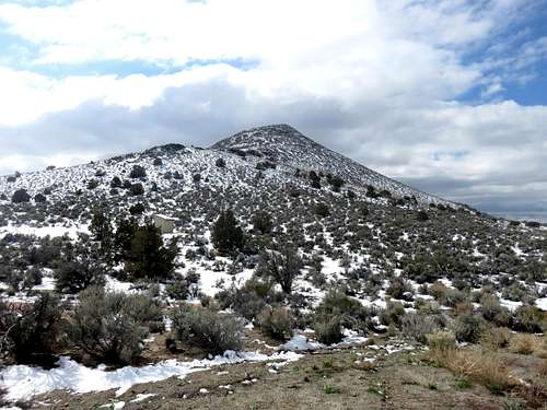
Sugarloaf Peak from the end of Capistrano Drive
Route
For the standard route, the one-way distance to the summit is 2.9 miles. Because the first two miles are gradual, this is ideal for mountain biking or trail running. The first two miles gain only about 265’ with numerous signs indicating distance still to go. Some of the signs are quite a bit off, but the sign indicating you’ve gone a mile is pretty accurate. After two miles, there is a sign at the turnoff to the summit road. This is where the last 480’ must be gained in 0.9 miles. If just hiking at a brisk pace, the summit can easily be reached in less than an hour.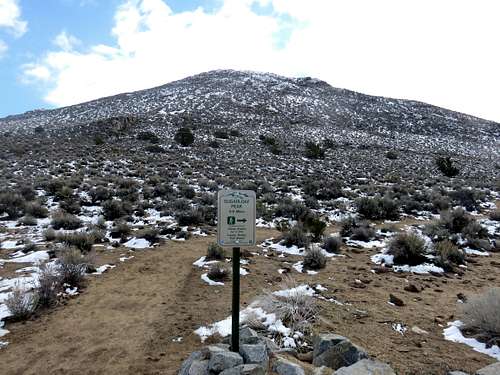
Trail sign to the summit road
For the southern route 1.5 miles up Calle De La Plata, head straight towards Sugarloaf Peak. You will reach the summit road in about 1/3rd of a mile. Then take the road for a half mile to the summit. The total one-way distance is only about 0.8 miles with an elevation gain of 560’.
From Capistrano Drive you can literally reach the summit in less than half a mile. But the recommended approach is to head towards the water tank and take the summit road up. Regardless of which way you go, you need to hop a fence. I saw no signs saying you can’t do that, as long as you stay away from the road next to a house directly west of the circle. Hike through the sage brush down to the water tank in about ¼ mile. Take the road heading west from the water tank and you will reach a sign saying 0.9 miles to Sugarloaf Peak. The total one-way distance for this route is about one and a quarter miles, gaining 480’.
Red Tape
For the northeast approach, there is a fence you’ll have to jump over. As of March 1, 2015 there are no signs indicating it is off-limits. Once over the fence you are on Sugarloaf Peak. Same for the southern approach where a clear path left of the fence line goes right towards the summit road.The standard route is dedicated to the mountain, and there is no red tape.