
|
|
Mountain/Rock |
|---|---|
|
|
49.14630°N / 87.82083°E |
|
|
Mountaineering |
|
|
Summer |
|
|
14350 ft / 4374 m |
|
|
Straddling the Chinese-Mongolian border, and just a stone’s throw from the Chinese-Mongolian-Russian tri-point, Mount Khüiten is Mongolia’s highest mountain. Khüiten, meaning “cold”, certainly lives up to its name. Several glaciers find their origin on the slopes of Mt. Khüiten, most notably the Potanin, Mongolia’s longest glacier at 14km. Not a difficult climb by mountaineering standards, the remote location is the main attraction here, making for a unique journey through a remarkable place. Khüiten is the high point of the Tavan Bogd massif, or Five Saints, which includes the other peaks of Naran (Sun), Malchin (Herder), Burged (Eagle), and Ölgii (Land). Tavan Bogd is the second highest summit in the Altai Range (the highest being Mount Belukha), and is protected by Altai Tavan Bogd National Park, a land of stunning scenery. Glaciated mountains, turquoise lakes, and immense grass-filled valleys dotted by the homes of Kazakh herders and eagle hunters, compose a landscape of overwhelming allure.
Oh yes, Khüiten offers adventure in a true wilderness setting and a cultural experience unlike anything else…
The Altai Mountain range spans parts of Mongolia, China, Kazakhstan, and Russia, and is home to an area that has remained relatively unchanged since the last ice age. With a few exceptions, the fauna has remained the same. Ibex, Arguli (sheep), and the endangered Snow Leopard can all be found in the Altai. The region also has an abundance of archeological sites, and many examples of prehistoric man have been discovered in the surrounding areas (for more information, check out the Wiki). The area also has one of the highest recorded numbers of yeti sightings in the world; there is even a trip report where climbers claim to have seen tracks en route to climb Mt. Snow Church, just one valley over from Khüiten. Though Mount Khüiten is commonly climbed, and trekking groups do visit basecamp and hike nearby Malchin Peak, it would be a rare day to find a crowd here. In fact, guided trips are often cancelled due to a lack of clientele. In the 6 days my partner and I spent around the mountain, we saw only three other groups, only one of which was heading for Khüiten’s summit.

Getting There
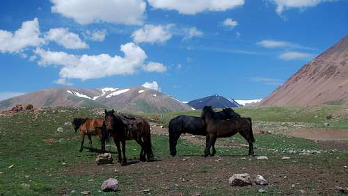
First, get yourself to Ölgii in Western Mongolia. This is most easily done by a domestic flight from Ulaan Bataar (we flew Hunnu Air without any problems; Aero Mongolia seemed ok as well). It is highly recommended to book early as flights are limited. Alternatively, one could take a (very) long bus ride from Ulaan Bataar, or fly into Khovd and hire a jeep for a 4 hour ride to Ölgii. There are also limited flights from Almaty, Kazakhstan. Once in Ölgii, you’ll need a jeep to the Tavan Bogd region, horses to pack your gear and food in to basecamp, and a permit. It is best to arrange all of this ahead of time from one of the local outfitters. Kazakh Tours seemed to have the best reviews and we were not disappointed. From Ölgii, a beautiful 4-5 hour jeep ride gets you to Altai Tavan Bogd National Park, where you’ll be dropped off with your horseman. From the border of the park, it is approximately 10 miles (16km) to basecamp. Your horseman will lead the way. If you decide to make the approach on your own, maps for Mongolia are available for purchase here. Be warned though, the approach is a roller coaster, the ground is heavily pocketed (uneven), and there may be difficult stream crossings and stretches of mud. With monster packs, this would make for a fairly brutal affair.
 Altai Tavan Bogd National Park
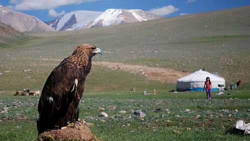 Western Mongolia, a Land of Kazakh Eagle Hunters
Route
If the glacier is in good shape, a fit party could choose any path heading west up the glacier and climb either the north or northwest ridge, climbing Mt. Khüiten from basecamp in a long day. We chose to make high camp since we were unsure of what to expect on the upper glacier, and wanted flexibility to climb Naraimdal. In the end, high camp made for short days and was enjoyable, but unnecessary. To High Camp From basecamp, head west on the trail towards Malchin, staying to the right of the moraine and setting foot onto the Potanin glacier wherever it looks convenient. Once on the glacier, it would be wise to rope up. Continue west on the glacier, aiming for a rocky outcrop on the upper glacier between Naraimdal and Khüiten (this outcrop is clearly visible from basecamp, and in this photo here). We found(!) several large hidden crevasses in the center of the glacier, and had better luck staying to the extreme right, then contouring towards the rocky outcrop up high. There is a flat area suitable for 1-2 tents on the northwest edge of the outcrop (rocks can be found here to use as anchors), and some flat areas on the glacier just west and northwest of there. Keep in mind that this section of the glacier is riddled with small crevasses, and all of these camp spots are exposed to weather. High Camp to Summit The north ridge is what we took, so I’ll describe that here. From high camp, head up moderate slopes towards an obvious col at the bottom of the north ridge, zigzagging around large crevasses along the way. From the col, head up an unexposed 35-40° degree ridge, which steepens as you go higher. Top out just below the summit and head right along the summit ridge, being mindful of cornices, until you reach the highpoint of Mongolia. The views in all directions are outstanding, especially so into China.
Alternatively, the NW Ridge of Khüiten looked straightforward as well, though a bit more exposed to objective hazards. The only other team we saw on the mountain climbed this route.
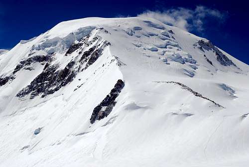 Mt. Khuiten
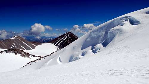 Climbers on the NW Ridge
More Peak Options
Malchin (4050m) and Naraimdal (4003m) are commonly climbed with Khüiten. Malchin sits on the Mongolian/Russian border, provides outstanding views of Khüiten, and is a great acclimatization hike from base camp. It is commonly hiked by trekking groups, and there is a use trail most of the way to the summit. Naraimdal (friendship peak) is easily climbable from Khüiten high camp, and is especially interesting as it is the tri-border point of Russia, Mongolia, and China. Note that some parties climb the wrong peak when heading for Naraimdal, and it is even mislabeled here (properly labeled here) . It is a lower rounded off bump where the ridgeline separating Russia and China meets the ridgeline between Khüiten and Malchin.
When to Climb
June through August is best.
Gear
Standard glacier travel and cold weather gear. The gear list should be identical to what one would bring on a climb of Mt. Rainier’s DC route.