La montagna chiama i suoi figli, ed essi rispondono fedelmente al suo appello…
Osvaldo Cardellina, Diario alpinistico, 1964-65
Page texts: @ OsvaldoCardellina"Osva", passed away on May 2, 2022. Page owners: Christian Cardellina e Osvaldo Cardellina. Any updates from September 12, 2022: Antonio Giani, page administrator, friend and climbing companion.
Testi della pagina: @ OsvaldoCardellina "Osva", scomparso il 2 maggio 2022. Proprietari pagina:Christian Cardellina e Osvaldo Cardellina. Eventuali aggiornamenti dal 12 settembre 2022: Antonio Giani, amministratore della pagina, amico e compagno di salite.
Threefold Overview
This Summit is part of the Group Mont Emilius (3.559m), located amongst the Vallons Comboé (West) Arbolle, just above the new Refuge of Arbolle (2.516m). It constitutes the final part of the long South Buttress South-southwest from Monte Emilius (3.559m) falls Little Emilius and the Mont Ròss de Comboé (3.301m); this ridge splits sending a branch in Northwest towards Col Carrel and Becca di Nona (3.142m) and another in the South to the Punte del Lago Gelato (3.115m) and the Trident de Comboé. Analyzing in a more targeted way to our own, to be observed as it wanders from the Mount Ròss to Southwest forming in succession the two collars of Col Ròss, the 7/8 elevations on Point of Frozen Lake (3.113/5m, the highest in like a small square forked tower), the Comboé's Pass and the namesake Trident, as the name implies, consists of three separate summits on the shaft Northeast/Southwest, the highest of which is the Northeast Top (3.083m), followed from Central Top (about 3.070m) and Southwest Summit (3.051m). If seen by Northwest (for ex. Ancient Alp Bren Dessus (1.672m), a magnificent place with views from the old decadent "rascard" between Turlin Dessus and Pila) in succession offer this: a tower with serrated at least six turrets, a rounded top in its lines and finally a perfect little triangular pyramid, from which descends towards the West-northwest a "Crestone". Among the latter two down a gully, where the snow remains even in the hottest summers. From this last point the ridge slopes linear, again towards the South-west, through fifteen small elevation, falling over the Vallon of Arbolle with its two lakes, connected through the effluent and the Shelter, just above the same (2.516m; open since July 1998; 66 beds, open in the summer season and adjacent locales for the winter), in this last section the ridge goes down with easy broken rocks and mixed with grass. Spreading, forms a vast grassy plain with scattered blocks, chats which was built with the Refuge nearby fountain. Surely the Southwest Top and the Central had already been reached by herdings or huntings, as reflected by the first climbers who, on the middle one, they found, as well as small traces of passage, a pole of the hunting ban. But from then on the ridge becomes more tricky and from Northeast Summit rushes with a jump of about seventy metres below the Col de Comboé (3.014m), descent, not easy, takes place through a rift-chimney about 25 feet "clogged" blocks stuck. It is possible to avoid this step across to the West of a steep ledge debris. The jump itself is divided into two parts, the first of which about forty meters, inclusive of the above passage, and a second a hundred feet less steep that reaches the Col de Comboé (3.014m) reaching the pass. Summit remains a very poorly visited and today, where poaching has been completely abandoned, even more left to itself. Incidentally the same complete traverse of the entire South-West Buttress to the Peak of Emilius is an epic undertaking that, given the low "image return" probably will not be repeated. Beautiful views from the summit, but limited to the district of Emilius by the mass of the same, while in the South stands partially the Mountain Chain of the Gran Paradiso.
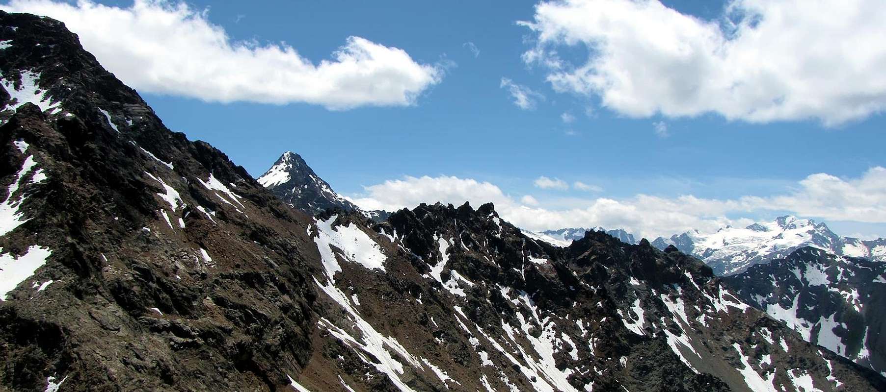
From left or North: Col (3.014m) & Trident de Comboé (3.083m, 3.071m, 3.057m) from Alp Bren (West), by Osw
Questa Sommità appartiene al Gruppo del Monte Emilius (3.559 m), sito tra i Valloni di Comboé ed Arbolle ed appena sopra l'omonimo nuovo rifugio (2.516 m). Costituisce la parte terminale del lungo Contrafforte Sud-sudovest che dal Monte Emilius (3.559 m) scende al Piccolo Emilius ed al Mont Ròss de Comboé (3.301 m); da questo la cresta si sdoppia inviando un ramo a Nordovest verso il Col Carrel e la Becca di Nona (3.142 m) ed un altro a Mezzogiorno verso le Punte del Lago Gelato (3.115 m) ed il Trident de Comboé. Analizzando in modo più mirato il nostro, da osservare com'esso si snodi dal Mont Ròss verso Sudovest formando in successioni i due colletti del Col Ròss, le 7/8 elevazioni delle Punte del Lago Gelato (3.113/5 m, la più elevata a guisa di torretta squadrata e bifida), il Col de Comboé e l'omonimo Trident, come dice la parola, costituito da tre distinte sommità poste sull'asse NE/SO, la più alta delle quali é la Punta Nordest (3.083 m), seguita dalla Punta Centrale (3.070 m circa) e dalla Sudovest (3.051 m). Se viste da Nordovest (ad esempio l'Alpe di Bren Dessus (1.672 m), magnifico posto d'oservazione con vecchio "rascard" decadente tra Turlin Dessus e Pila, in successione offron questa immagine: una torre dentellata con almeno sei torrette, una punta arrotondata nelle sue linee ed infine una perfetta piramidina triangolare, dalla quale scende verso Ovest-nordovest un Crestone. Tra queste ultime due discende un canalone, ove la neve resiste anche nelle estati più torride. Da quest'ultima punta la cresta digrada lineare, sempre in direzione Sudovest tramite una quindicina di piccole elevazioni, discendendo sopra il Vallone dell' Arbolle con i suoi due laghi, collegati dall'emissario del primo od Orientale, ed il Rifugio, appena sopra i medesimi (2.516 m; aperto dal Luglio 1998; 66 posti letto; aperto nella stagione estiva ed adiacente locale per quella invernale); in quest'ultimo tratto la cresta scende con facili rocce rotte frammiste ad erba. Allargandosi, forma un vasto plateau erboso con blocchi sparsi o "clapeys", oltre il quale é stato costruito il Rifugio con vicina fontana. Sicuramente la Punta Sudovest e quella Centrale eran di già state visitate da pastori o cacciatori, come da riscontro dei primi salitori che, su quella di mezzo, trovarono, oltre a piccole tracce di passaggio, una palina di divieto di caccia. Ma da lì in avanti la cresta diventa più ostica e dalla Punta Nordest precipita con un salto di una settantina di metri circa sul sottostante Col de Comboé (3.014 m); la discesa, non facile, avviene tramite una spaccatura-camino di circa 25 metri "intasato" da blocchi incastrati. Risulta possibile evitare questo passaggio attraversando ad Ovest su d'una ripida cengia detritica. Lo stesso salto é suddiviso in due parti, delle quali la prima d'una quarantina di metri, comprensiva del passaggio di cui sopra, ed una seconda d'una trentina di metri, meno ripida, che raggiunge il Col de Comboé. Rimane una Cima veramente scarsamente visitata ed oggi, dove il bracconaggio é stato completamente abbandonato, ancora più abbandonata a se stessa. Daltronde la medesima traversata completa dell'intero Contrafforte Sud-sudovest fino alla Vetta dell'Emilius rimane un'impresa epica che, visto lo scarso "ritorno d'immagine", probabilmente non toverà alcun proselitismo. Dalla Vetta belle vedute, ma limitate sul circondario dell'Emilius per la massa dello stesso, mentre a Mezzogiorno si staglia parzialmente la Catena del Gran Paradiso.
From left: Piccolo Emilius, Mont Emilius, Punte del Lago Gelato & Trident de Comboé from P. della Valletta, by emilius
Arbolle Vallon & Trident de Comboé East Side, by livioz
First Ascents
First on the Summit: Osvaldo Cardellina and Camillo Roberto Ferronato, (Aug 04th, 1974), in ascent from Arbolle Lake and through the South-southwestern Ridge.
In winter: Unknown.
S-SW and NE Ridges (Integral Buttress SW of Monte Emilius): Osvaldo Cardellina and Camillo Roberto Ferronato, (Aug 04th, 1974), in ascent from Pila, Arbolle Vallon and in descent to Comboé Pass, with subsequent crossing towards Punte del Lago Gelato, Col Ròss, Mont Ròss de Comboé, Little Emilius and Monte Emilius.
W-NW Eperon (S-SW Summit): Osvaldo Cardellina, lone, (Oct 07th, 2007), in ascent from Pila, Comboé and Gran Plan Alps with traverse of the three Tops, round trip.
Getting There
BY CAR:
From TORINO MILANO, etc: Motorway A5. Exit at Ivrea City, Quincinetto Common (PIEMONT) or at Pont Saint Martin, Verrès, Chatillon, Nus Municipalities. By SS.26 from Ivrea Town towards: Quincinetto, Pont Saint Martin, Donnas, Hône-Bard, Arnad, Pont Bozet, Champorcher, Champdepraz, Fénis, Saint Marcel, Grand Brissogne, Pollein and Charvensod Municipalities.
Better departure:
From Pont Suaz-Aosta(567m, 583m) before by the Cableway to Pila Resort (1.800m); after from this to Chamolé Lake and Hill 2.325m, 2.641m) with the Chair Lift towards Chamolé Upper Station (2.309m) and path. Also through the regional Road from Pont-Suaz towards Charvensod Commune, Pèroulaz, Les Fleurs and Pila.
Other possibilities of entering partially in the route starting from:
Pollein (575m; secondary road) or from Charvensod (746m; main road and connection) to Arpisson small Valley and Martsaouchy Damon (1.410m), through dirt farms road, and Arpisson Lower & Upper (1.951m, 2.010m) Alpages with ancient path. Federigo Zullo Bivouac through moraines on Western Arpisson Glacier. Charvensod to Dard-Comboé-Arbolle Gorge and small Valleys towards Ponteilles(1.697m) Alp & Waterfall, through dirt road, Comboé Alp & Saint Ours private Shelter (2.114m), through dirt road, and Arbolle Refuge(2.516m), nearby two Lakes (2.495m, 2.497m). Aymavilles(646m) to Western Pila Conca, through Main Road to Cogne Valley, alternative to Ozein/Turlin Dessus Hamlets and dirt road to Pila-Posse. Aymavilles towards Cogne Valley with Regional Main Road: Vieyes (1.132m) Fraction; continue to Silvenoire, Epinel and Crétaz Hamlets, Cogne(1.534m) Resort, through Main Road. From Cogne towards Gimillan Village(1.785m): from this in North to Grauson-Lussert Vallon and Frog, Corona, four Lussert Lakes also in Northwest towards Arpisson Alp Franco Nebbia Bivouac, through path in Upper Arpisson Vallon to Garin Hill (2.815m) with descent to Arbolle Refuge into the homonym Vallon.
From Arbolle Vallon final descent towards:
From this to Chamolé Hill and Lake(2.641m, 2.325m), Chair Lift Chamolé Upper Station (2.309m), St. Grat Hermitage (1.773m), Pila-Resort (1.800m) and Pont Suaz-Aosta (567m, 583m).
From FRANCE: through the Mont Blasnc Tunnel to Entrèves-crossroads to Vény/Ferret Valleys - Mountain Guides of Courmayeur- La Saxe Rock Gym - Courmayeur. By Little Saint Bernard Pass, closed since November until half May to La Thuile Valley - Pré Saint Didier - Courmayeur. It is not necessary to take Motorway A5: you can drive on SS.26, in the direction ofAOSTA - IVREA - TURIN.
BY PLANE:
Aeroporto "Corrado Gex" Saint Christophe (Aosta).
Approaches
Approach A from Pila Resort through the two Replan Hill:(2.325m) on foot through the various paths n° 19/19A/19B, passing respectively to the Alpage of Chamolé (2.532m; fountain front pasture), also towards the Bois (Wood) Chanté, going up directly into a small vallon to Chamolé Lake (2.325m). Or to the same point by a Chairlift Chamolé from Pila, starting Bettères. From here the path to the Northeast n° 19 leading to the two Hills of Replan; dubbed the small and of the same name pointing to the left to reach the Northern Col and the small winding path always n° 19 off at Comboé (2.114m; private retreat of the Canons of Saint Orso; fountain nearby the alpage). From this directed to the South with the path and, after rounding a pond, cross the Torrent de Comboé following the path n° 16, which leads to Federigo Bivouac and Becca di Nona on Carrel Hill. Won a first slope quite steep and difficult, to achieve the Plan Valé (2.379m); come to the perimeter ruins of an old pasture, or even earlier neighbor the fork 2.329 meters from Grand Plan Alp, through to South or Southeast (depending on the route chosen) bringing near the Lago Gelato Tops and continue in diagonal route to the Southeast on steep gray moraine below Comboé Pass (3h'00).
Variants:
a) - this trail connection, certainly more "comfortable", but that requires a larger circle first to the South and then returned Northeast, you can get to the bottom of the vallon, reaching the Grand Plan from Comboé (calculate half more hour).
b) - Of course you can make the approach starting from Federigo (2.907m) nearby the Col Carrel following the path downhill. In this case, you have the advantage of accommodation at a good altitude, bearing in mind that this choice should rise by Northeast Crest from Col Comboé (3.014m); after a descent of a few hundred metres from the camp, agrees to go Southwest and, passing below the West Face Mont Ròss remaining at a safe distance from it and doubling at the base the West-northwest Spur Punte Lago Gelato, climb through steep scree and gray moraines or through snowfields at the beginning of season.
Avvicinamento A dal Comprensorio di Pila tramite i Colli di Replan (2.325 m):Da Pila (nota località sciistica, raggiungibile da Aosta in auto, pullman con la Strada Regionale oppure tramite funivia), raggiungere il Lago di Chamolé (2.325 m, anche qui in seggiovia o a piedi tramite i vari sentieri n° 19/19A/19B) che passano rispettivamente per l'Alpe di Chamolé (2.532 m; fontana davanti all'alpeggio), oppure attraverso il Bois Chanté, salendo direttamente tramite un valloncello al Lago di Chamolé (2.325 m), ove si può giungere anche per mezzo della Seggiovia di Chamolé da Bettères. Da qui inizia verso Nordest il sentiero n° 19 che conduce ai due Colli di Replan (pannelli gialli); scartato quello Meridionale e doppiata l'omonima puntina a sinistra raggiungere il Colle Settentrionale e con il piccolo e tortuoso sentiero sempre n° 19 scendere a Comboé (2.114 m; rifugio privato dei Canonici di Sant'Orso; fontanile presso l'alpeggio). Da questo indirizzarsi a Meridione con il sentiero e, dopo aver doppiato un laghetto, attraversare su d'una passerella in legno il Torrent de Comboé seguendo il sentiero n° 16, adducente al Bivacco Federigo Zullo ed alla Becca di Nona. Dopo una passerella in legno sul medesimo e vinto un primo pendio alquanto ripido e faticoso in mezzo al bosco, raggiungere su terreno aperto il Plan di Valé; alle rovine perimetrali d'una antica alpe (2.379 m), oppure anche prima al bivio 2.329 metri, collegante l'Alpe Grand Plan, attraversare a Sud o Sudest (a seconda della via prescelta) portandosi verso le Punte del Lago Gelato ed il successivo ripido pendio morenico grigiastro sotto il Colle di Comboé (3h'00).
Varianti:
a) - a questo sentiero di collegamento, sicuramente più "comodo", ma tale da richiedere un giro più largo dapprima verso Sud per poi rientrare verso Nordest, si può arrivare raggiungendo sul fondo del vallone il Grand Plan da Comboé (calcolare mezz'ora in più).
b) - Logicamente si può effettuare l'avvicinamento partendo dal Bivacco Federigo (2.907 m) al Colle Carrel seguendo il sentiero in discesa. In questo caso si ha il vantaggio del pernottamento ad una buona quota, tenendo presente che con questa scelta conviene salire tramite la Cresta Nordest dal Colle di Comboé (3.014 m); dopo una discesa d'un centinaio di metri dal bivacco, conviene dirigersi a Sudovest e, passando al di sotto della Parete Ovest del Mont Ròss de Comboé e doppiando lo Sperone Ovest delle Punte del Lago Gelato, risalire tramite ripide pietraie grigiastre oppure tramite nevati.
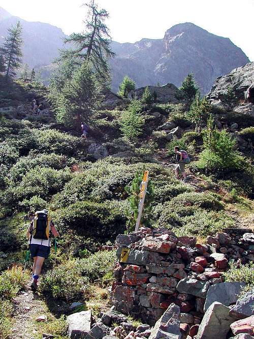
Approach B Arbolle Refuge: It is also possible to get off the Refuge Arbolle 2.516m with a small path n° 18 which runs to the North and, after reaching the Alp Grand Plan (2.158m; remains) through a narrow gorge, crossing the Torrent de Comboé with a diagonal from right to left in the middle of a heap of stones; From this point the path part of a diagonal n° 18 (yellow signals immediately to the East alp), which is directed towards Plan Valé and Federigo Zullo Camp. Take the same for about one-third to go up directly to the Comboé Trident first through bushes and trees and then through large rocks, or reach the Plan Valé and then navigate to the right or Southeast (EE; calculated for both 1h'30 1h'45).
Avvicinamento B dal Rifugio di Arbolle:Inoltre é possibile scendere dal Rifugio d'Arbolle 2.516 m con un piccolo sentiero n° 18 che gira verso Nord e, dopo aver raggiunto l'Alpe diroccata di Grand Plan (2.158 m) tramite una stretta gola, attraversa il Torrent de Comboé con un diagonale da destra verso sinistra in mezzo ad una pietraia; da questo punto parte un il sentiero diagonale n° 18 (cartello giallo subito ad Est) indirizzantesi verso Plan Valé ed il Bivacco Federigo. Percorrere il medesimo per circa un terzo per poi salire direttamente verso il Trident de Comboé dapprima tramite cespugli ed alberi e poi tramite grandi pietraie, oppure raggiungere il Plan Valé e poi traversare a Sudest (EE; calcolare per entrambi da 1h'30 a 1h'45).
Approach C from Pila through Plan Fenêtre Hill or from Ponteilles to the Vallon of Comboé: Pila catch up with the previous Approach A to Chamolé Pasture (2.532m); leaving right (South) detours to Lake Chamolé continue instead with the path n° 20 to the Northeast, that reached the junction in altitude 2.059meters with the private dirt road that goes from the Pasture and from the Hermitage of San Grato (1.787m), is entered in the woods, with almost flat and undulating path, arrive at the next fork at 2.140 meters, where the steep trail that climbs from the latter. With a final stroke on a slight slope and panorama you get to the Hill Plan Fenêtre (2.229m), hence with quiet down in the Southeast are within the Vallon and Alp Comboé (2.114m), where you reconnect with the previous A.
Variants starting from below:
a) - this path you can get, as mentioned above, by means of a private dirt road that stretches from San Grato (1.787m), or by means of steep unnumbered mule-track that goes through the Black Forest Combatissière just Eastward.
b) - It is also possible to reach the Walloon Comboé from this of Dard, the one below it, with different starting points, reaches Alp Ponteilles and its beautiful waterfall (1.697m, around 1.640 meters); a path numbered 14D bastion dating this charming coming to Comboé Dessous (Low, 2.041m) at the entrance of the vallon immediately below and through the prairies to Alp Comboé (1h'00/1h'10 from Ponteilles Alpage).
Avvicinamento C da Pila attraverso il Col Plan Fenêtre o da Ponteilles al Vallone di Comboé: da Pila raggiungere con il precedente Avvicinamento A l'Alpe di Chamolé (2.532 m); lasciando a destra le deviazioni per il Lago di Chamolé, continuare invece verso Nordest con il sentiero n° 20 che, raggiunto il bivio con la strada poderale che risale dall'Alpe e dall'Eremitaggio di San Grato in altitudine 2.059 metri, si immette nel bosco e, con percorso ondulatorio e quasi pianeggiante, arriva al successivo bivio 2.140 metri dove perviene la ripida mulattiera che sale da questi ultimi. Un ultimo tratto in falsopiano e panoramico porta al Colle Plan Fenêtre (2.229 m), donde con tranquilla discesa a Sudest si raggiungono il Vallone e l'Alpe di Comboé (2.114 m), dove ci si riconnette col precedente A.
Varianti partendo da più in basso:
a) - a questo sentiero si può arrivare, come detto sopra, tramite una strada poderale che parte da San Grato (1.773 m), oppure per mezzo della ripida mulattiera non numerata che sale attraverso la Foresta Nera di Combatissière appena più ad Oriente,
b) - Inoltre é possibile raggiungere il Vallone di Comboé da quello sottostante del Dard che, con vari punti di partenza, perviene all'Alpe di Ponteilles ed alla sua bella cascata (1.697 m, 1.640 metri circa); un sentiero n° 14D risale questo spalto suggestivo arrivando al Comboé Dessous (2.041 m) all'ingresso del vallone e subito appresso per praterie all'Alpe di Comboé (1h'00/1h'10 da Ponteilles).
Routes
Route A (S-SW Ridge): start right behind the Refuge Arbolle going after a small plateau with scattered blocks, between grassy slopes which happen easily broken rocks mixed with grass and detritus. Move to the edge of the ridge and pass successively fifteen small bumps until you reach a narrow saddle (I°/I°+). A later rounded hump (2.894m), followed by other insignificant elevations, leading with a final stretch more linear to the Punta Southwest (3.051m). Get off to a dual seat divided by a spike bifurcate and more easily reach the Central Summit (3.071 meters about); get off at the next slot-notch followed by two other small bumps and a square and forked tower. The short descent from the latter leads to a carving more pronounced with a mini pinnacle, after which a serie of five pinnacles (I+°/II°-) lead to the last or the Northeast Summit, the highest (3.083m; EE/A/F+; 1h'45/2h'15).
Route A (Cresta S-SO):iniziare subito dietro il rifugio, presso la fontana, risalendo, dopo un piccolo plateau con "clapeys" o blocchi sparsi a quota 2.540/50 metri circa (a destra un muretto in pietra a secco protettivo), tra pendii prativi all'altitudine di 2.713 metri ai quali succedono facili roccette rotte frammiste ad erba e detriti. Portarsi sul filo di cresta e superare in successione una quindicina di piccole elevazioni fino a raggiungere una selletta (I°/I°+). Una successiva gobba arrotondata 2.894 m), seguita da altre insignificanti protuberanze, conduce con un tratto più lineare alla Punta Sudovest (3.051 m). Scendere ad una doppia sella divisa da uno spuntone biforcuto ed ancora più facilmente raggiungere la Punta Centrale (3.071 m); scendere al successivo intaglio seguito da altre due minuscole asperità e da una torretta squadrata e biforcuta. La discesa da quest'ultima conduce ad un intaglio più pronunciato, oltre il quale cinque ben distinti pinnacoli o torrioncini (I°+/II°-) conducono all'ultimo o Nordest, il più elevato (3.083 m; EE/A/F+; 1h'45/2h'15).
First part on S-SW Buttress crossing Trident de Comboé towards Punte del Lago Gelato, by Osw & Camillo Roberto Ferronato
Route B from Arbolle Shelter or Comboé Alp through Comboé Pass and NE Crest: it is also possible to get off the Refuge Arbolle 2.516m with a small path n° 18 which runs to the North and, after reaching the Alp Grand Plan (2.158m; remains) through a very narrow gorge, crossing the Torrent de Comboé with a diagonal from right to left (East/West) in the middle of a heap of stones. From this point the path part of a diagonal n° 18 (yellow signals immediately to the East alp), which is directed towards the Plan Valé and Federigo Zullo Bivouac. Take the same for about one-third to go up directly to the overhanging Comboé Pass first through bushes and trees and then through large rocks, or reach the Plan Valé (2.379m) and then navigate to the right (South) and, rounding behind the Ridge-Spur West-northwest (to the South) of Lake Gelato Summits, climb the progressively steep moraine first gray and then red-brown leading to Pass (EE; calculated for both 1h'30 1h'45 from the Arbolle Shelter or by Comboé Vallon). The ascent is via a jump divided into two parts, of which the first of thirty meters easier (II°/II°+) and the second of about forty metres, much steeper, not easy: in this climbing through a split-chimney about 25 meters"clogged" by blocks stuck, unsteady and unsafe (II°+/III°+/III°-). It is possible to avoid this step through immediately to the West on a steep ledge with debris (A/PD-/AD+; 0h'45/1h'00; total 2h'30/2h'45).
Via B dal Rifugio di Arbolle o dal Comboé tramite l'omonimo Colle e la Cresta NE: é possibile scendere dal Rifugio d'Arbolle con un piccolo sentiero n° 18 che gira verso Nord e, dopo aver raggiunto l'Alpe diroccata di Grand Plan (2.158 m) tramite una stretta gola, attraversa il Torrent de Comboé con un diagonale da destra verso sinistra in mezzo ad una pietraia; da questo punto parte un il sentiero diagonale n° 18 (cartello giallo subito ad Est) indirizzantesi verso Plan Valé ed il Bivacco Federigo. Percorrere il medesimo per circa un terzo per poi salire direttamente verso il Col de Comboé dapprima tramite cespugli ed alberi e poi tramite grandi pietraie, oppure raggiungere il Plan Valé e poi traversare a destra e, doppiando alla base il Crestone Ovest-nordovest (verso Sud) delle Punte del Lago Gelato, salire la ripida morena prima grigiastra e poi rosso-bruna che conduce al Colle (EE; calcolare per entrambi da 1h'30 a 1h'45 da Arbolle o Comboé). Infine risalire la breve ma impegnativa Cresta Nordest della Sommità (3.083 m): la cresta diventa più ostica e dalla Punta Nordest precipita con un salto di una settantina di metri circa sul sottostante Col de Comboé (3.014 m). La salita avviene tramite un salto suddiviso in due parti, delle quali la prima d'una trentina di metri più facile (II°/II°+) e la seconda d'una quarantina di metri, molto più ripida, non facile: in questa si arrampica tramite una spaccatura-camino di circa 25 metri "intasato" da blocchi incastrati nonché pericolanti (II°+/III°+/III°-). Possibile evitare questo passaggio attraversando ad Ovest su d'una ripida cengia detritica (A/PD-/AD+; 0h'45/ 1h'00; in totale 2h'30/2h'45).
Punte del Lago Gelato & Trident de Comboé NW Faces, by Antonio
Route C (through the W-NW Edge of S-SW Summit): with the way previous continue southbound without climb to the Col de Comboé. After rounding the right the two parallel ribs of Punte del Lago Gelato, reach the base edge of the West-northwest Punta Southeast of the Trident point-altitude 2.536 meters, located on the moraine of the base between the two parallel spurs that descend from Trident de Comboé to West-northwest. Leaving on the left (East) steep snowfields that originate a gully that ends to the saddle between the Punta S-SW and the Central, head instead to the right (South) and with a crossing on steep rocky steps, often covered with grass, reaching the wire of the edge in altitude 2.550/60 meters about. The same goes up separating the Northwest Face from the more turned to the West and that falls on the gorge between Comboé and Arbolle. Climb quite easily the first section reaching a shoulder inclined to share 2.850/70 meters, where the crest changes direction from West to Northwest (I°+). The next wall is directly addresses (from II° to III° - on the edge of the ridge), or hovers on the left to a steep channel where stationed snow also until the end of summer reaching a detrital ledge slanting from North to South. The next wall, below a small promontory rounded, you win through a rift in the channel between the brownish rocks on the left and reddish (II°/II°+); it is now on a longer linear and easy that leads under the turret final (I°/I°+). One last short slope is circumvented by a small ledge on the right and immediately through very broken rocks you reach the Summit (A/PD-/PD; 1h'45/2h'15 for about 500 meters from the base; 3h'45/4h'15 from Rifugio Arbolle or by the Vallon Comboé; 5h'00/6'00 from Pila). Not hard climbing, but delicate to the quality of the rock and in some places exposed; also it requires the ability to research the passages.
Via C (per lo Spigolo O-NO della Punta S-SO):con la via precedente continuare verso Sud senza risalire verso il Col de Comboé. Dopo aver doppiato sulla destra le due costole parallele delle Punte del Lago Gelato, raggiungere la base dello Spigolo Ovest-nordovest della Punta Sudest del Trident all'altitudine-punto 2.536 metri, sito sulla morena di base tra i due speroni paralleli che scendono dal Trident de Comboè verso Ovest-nordovest. Lasciando sulla sinistra (Est) i ripidi nevai che originano un canalone terminante alla sella tra la Punta S-SO e quella Centrale, dirigersi invece verso destra (Sud) e con una traversata su ripidi gradoni rocciosi, spesso ricoperti da erba, raggiungere il filo dello spigolo a quota 2.550/60 metri circa. Lo stesso sale separando il Versante Nordovest da quello più rivolto ad Occidente e che precipita sulla gorgia tra il Comboé ed Arbolle. Salire abbastanza facilmente il primo tratto raggiungendo una spalla inclinata a quota 2.850/70 metri circa, dove la cresta cambia direzione da Ovest a Nordovest (I°+). Il muro successivo si affronta direttamente (dal II° al III°- sul filo di cresta), oppure si aggira sulla sinistra per un ripido canale dove staziona la neve anche fino al termine dell'estate raggiungendo una cengis detritica obliqua da Nord a Sud. Il muro successivo, sottostante ad un piccolo promontorio arrotondato, si vince passando in una spaccatura canale tra rocce brunastre a sinistra e rossastre (II°/II°+); si raggiunge così un tratto più lineare e facile conducente sotto la torretta finale (I°/I°+). Un ultimo breve risalto viene aggirato tramite una cengetta subito sulla destra e per rocce molto rotte si raggiunge la Sommità (A/PD-/PD; 1h'45/2h'15 per 500 metri circa dalla base; 3h'45/4h'15 dal Rifugio di Arbolle o dal Vallone del Comboé; 5h'00/6'00 da Pila). Salita non difficile, ma delicata per la qualità della roccia ed a tratti esposta; inoltre necessita la ricerca dei passaggi.
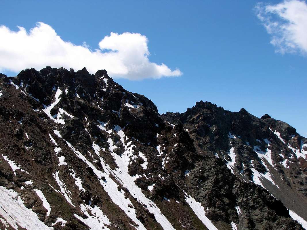
S-SW Buttress from Mont Ròss (left) towards the Trident, by Antonio
Mountain Condition
Meteo: you can find all the needed informations at the official site of the Valle d'Aosta Region:
"Guida del Monte Emilius", di Osvaldo Cardellina Editore in collaborazione con il Club Alpino Italiano Sezione di Aosta, Dicembre 1978.
"Guida dei Monti d'Italia – Emilius Rosa dei Banchi Parco del Mont Avic" di Giulio Berutto e Lino Fornelli - Club Alpino Italiano/Touring Club Italiano, Marzo 2005.
"Guida delle Alpi Occidentali" di Giovanni Bobba e Luigi Vaccarone C.A.I. Sezione di Torino Volume II (parte II), 25 Maggio 1896.
"Diari Alpinistici" di Osvaldo Cardellina e Indice Generale accompagnato da Schedario Relazioni Ascensioni 1964-2019 (inediti).
Kompass "Gran Paradiso Valle d'Aosta Sentieri e Rifugi" Carta turistica 1:50.000.
L'Escursionista "Conca di Aosta-Pila-Monte Emilius" Carta dei sentieri (n° 4) 1:25.000.
Hapax "Les Sentiers Comunità Montana Monte Emilius", Luglio 2000 1:25.000.
Enrico Editore Ivrea-Aosta "Gruppo del Gran Paradiso" 1:50.000.
I.G.C. Istituto Geografico Centrale, Torino "Carta delle Passeggiate ed Escursioni in V.D.A. Conca di Pila-Gressan, 1:20.000.
Parents refers to a larger category under which an object falls. For example, theAconcagua mountain page has the 'Aconcagua Group' and the 'Seven Summits' asparents and is a parent itself to many routes, photos, and Trip Reports.


 3556 Hits
 81.18% Score
 13 Votes

 From left or North: Col (3.014m) & Trident de Comboé (3.083m, 3.071m, 3.057m) from Alp Bren (West), by Osw
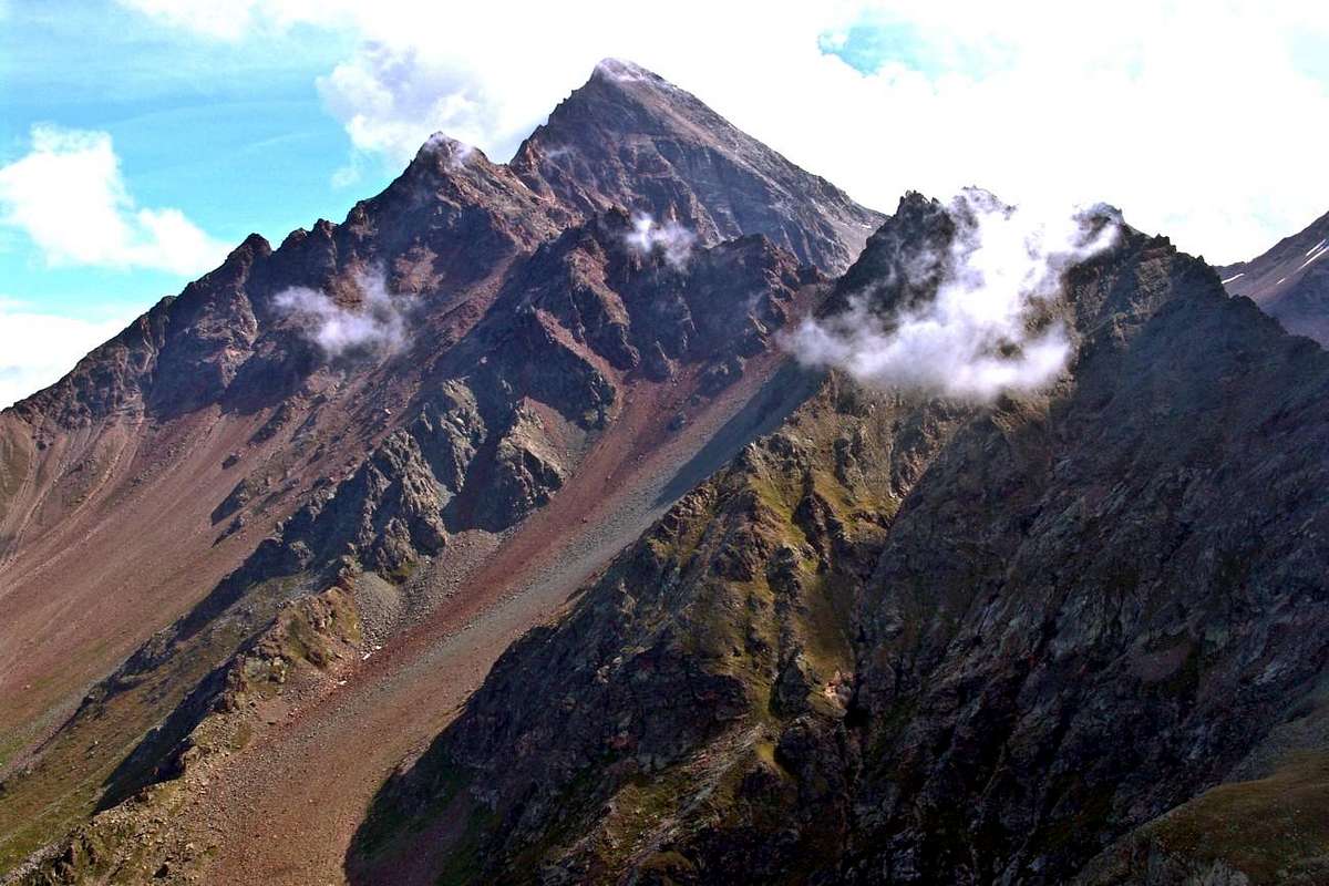 From left: Piccolo Emilius, Mont Emilius, Punte del Lago Gelato & Trident de Comboé from P. della Valletta, by emilius
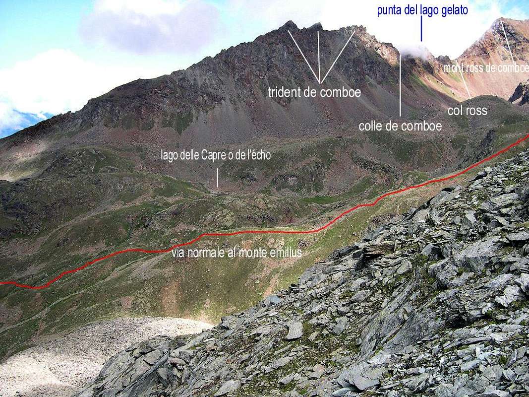 Arbolle Vallon & Trident de Comboé East Side, by livioz
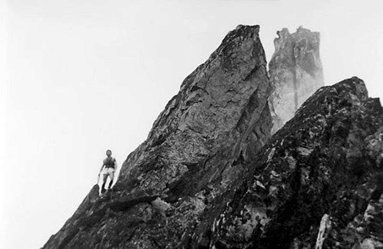


 Punte del Lago Gelato & Trident de Comboé NW Faces, by Antonio