
-
 5789 Hits
-
 82.48% Score
-
 15 Votes
|
|
Mountain/Rock |
|---|---|
|
|
46.99536°N / 11.71056°E |
|
|
Tyrol |
|
|
Mountaineering |
|
|
Summer |
|
|
10161 ft / 3097 m |
|
|
Overview
Geographical classification: Alps - Eastern Part > Zillertal Alps > Hochsteller
Hochsteller m 3097
Hochsteller is a broad and secluded rocky mountain belonging to the range called Zillertal Alps (Austria) or Alpi Aurine (Italy). The summit is located near the Italian-Austrian boundary ridge, entirely on the Austrian side, between Monte Lavizza – Haupenhöhe to the South and Kälberlahnerspitze to the NW. A rarely climbed peak until a few years ago, nowaday more frequented in reason of its interesting Normal route. During the climb you can enjoy stunning views over Croda Alta/Hohe Wand, Croda Rossa/Rotbachlspitze, Cima Grava-Hochfernerspitze, Hintere Weisspitze and Grosser Moseler. Also the summit views are wide over the surrounding ranges, as Tuxer Alpen, Alpi Aurine - Zillertal Alps, Val di Vizze-Pfitscher Tal summits and the superb lake Schlegeis-Stausee.
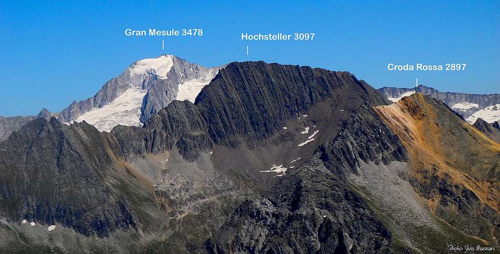
When viewed from the Italian side, the mountain has the appearance of a dark and square rocky trapeze truly distinctive, with a long and slightly notched summit ridge facing South. Along this ridge it runs the upper section of the Normal route, joining Monte Lavizza, which someone consider as a fore-summit of Hochsteller, with the true summit. The other main ridges are the more jagged NW and NE ridges, surrounding the Hochstellerkees glacier.


Getting There
Road Approach
The starting point to climb is Val di Vizze – Pfitscher Tal
Getting to Val di Vizze
- From Brennero Motorway exit Vipiteno-Sterzing 947 m and take the road n. 508 entering Val di Vizze and reaching the villages of Prati-Wiesen, Caminata-Kematen, San Giacomo-St. Jacob and Sasso-Stein m. 1508, where the road becomes unpaved. The road rises quickly towards Passo di Vizze, but cars are allowed as far as the IV hairpin m. 1806. Parking.


Approach to Passo di Vizze – Pfitscher Joch m. 2275
From Sasso to Passo di Vizze the road is open to private vehicles as far as the IV hairpin along the road (altitude 1806 m). From here take a path in the North direction (signposts «Pfitscher Joch»), or alternatively carry on briefly along the road, then turn to left following the path n. 3. 1 hour and a half by walking. Otherwise a minibus service is available; there are frequent departures both from Sasso-Stein and Passo di Vizze. See here more info: Passo di Vizze minibus
Hochsteller Normal Route from Passo di Vizze
Hochsteller Normal route from Passo di Vizze report
Summit altitude: m 3097
Difficulty: Alpine F+
Vertical gain: 822 m from Rifugio Passo di Vizze m 2275
Exposure: South
Hut: Rifugio Passo di Vizze m 2275
Starting point: Passo di Vizze m 2251
A very interesting and panoramic route inside a wild environment; it starts following at first a good path, then it involves an easy scramble up the rocky summit ridge


From the hut descend briefly the dirt road towards Passo di Vizze and take soon on the right a track heading to the lake located below the hut. From the track it immediately begins a well-worn path to Croda Rossa-Rotbachlspitze, crossing some meadows eastwards and reaching the border crest between Italy and Austria, marked by various boundary stones. Continue on the ridge in the direction of the well visible Croda Rossa, then leave the main route to Croda Rossa nearby a characteristic rocky shoulder at 2600 meters (cairn). Here an uncertain track branches off on the right, descending slightly and crossing vegetated slopes and scree around Croda Rossa eastern slopes just below its rocky summit.


Soon the path becomes more obvious up a steep grassy slope to reach the beautiful terrace pastureland named "Hohe Öfen" at about 2730 m. where the unmistakable shape of Hochsteller appearing like a dark trapezius begins to be visible. Descend briefly to reach the wide grassy saddle called Haupentalscharte m. 2684.

Climb up between blocks and debris, keeping the left side of the ridge rising towards Hochsteller foresummit; the path becomes very steep in the upper part getting the foresummit named Haupenhöhe or Monte Lavizza m 3040, summit cairn, from which a superb view towards the Alpi Aurine appears.


From the fore-summit turn to left (North) and start to scramble up a long rocky ridge, rather easy but involving some exposed moves, leading to the summit.
Descent: reversing the same route
Essential gear

High mountain gear, eventually a rope. Be aware that in late spring and early summer it's possible to find snow or ice along the summit ridge; in that case crampons and an ice-axe are reccomended
Red Tape


No fees no permits needed. The peak is located within the Zillertal Alps Natural Park, a wild and preserved environment.
When to Climb
Best season goes from middle June to the end of September
Hut


- Rifugio Passo di Vizze m 2276
Meteo
Guidebooks and maps
 |
 |
 |
Guidebooks
“Alpi Aurine” by F. Cammelli – W. Beikircher Guida dei Monti d’Italia CAI
“Prestigiosi 3000 del Sudtirolo” by Hanspaul Menara
Maps
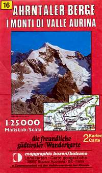
"Ahrntaler Berge - I monti di Valle Aurina" map 1:25.000 - Mapgraphic Bolzano