
-
 3926 Hits
-
 85.12% Score
-
 20 Votes
|
|
Mountain/Rock |
|---|---|
|
|
43.39300°N / 103.4283°W |
|
|
Fall River |
|
|
Hiking |
|
|
3755 ft / 1145 m |
|
|
Overview
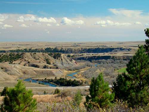 Cheyenne River Canyon View
Maverick Mountain is one of the few publicly-accessible summits in the Seven Sisters Range of Fall River County, South Dakota. While this ranked summit anchors the northeastern corner of the Seven Sisters Range of the Black Hills, it simply shows up on peak lists as “3755”. The mountain lies at the southwest corner of the small community of Maverick Junction. So it seems quite appropriate to call this summit “Maverick Mountain”. Lists of John states that this summit has 310 feet prominence, and is ranked #222 in the Black Hills. The forest is part of the Black Hills National Forest.
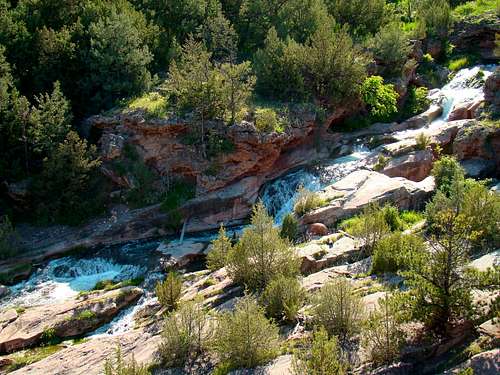 Fall River Falls
Few hikers venture up this mountain for a variety of reasons. It is one of the lowest ranked summits in the Black Hills, it has no official name and the entire Seven Sisters Range has somewhat of a local reputation as being mostly inaccessible because so much of the range is on private land. However, an old road on the mountain makes for a nice trail to just below the summit area. There are plenty of trees along the route, but not thick everywhere. The views along the route are rather impressive in some places. Perhaps the most interesting views are those of Angostura Lake to the south and the badlands along the Cheyenne River valley to the east-southeast. From some parts of the summit, there are views west of some of the peaks and canyons of the Seven Sisters Range, plus views of Battle Mountain and Friendshuh Mountain to the northwest. When you hike there, you can reasonably assume you will likely have the mountain to yourself, unless you hike during a popular local hunting season. Maverick Mountain is a ridge much like the rest of the summits in the Seven Sisters Range, that are gently sloped to the east-southeast, with the sharpest rises on the west and north sides. Brady Canyon sets the western boundary for Maverick Mountain. The Fall River flows along the northern edge of the mountain, making for some sharp drops into that canyon. Fall River Falls lies at the northeastern corner of the mountain, and then the river curves sharply to the south where it joins the Cheyenne River. On the eastern slopes, there are a number of flash flood gullies that reveal an interesting collection of rocks. The mountain is the highpoint in the Romey Game Production Area in Fall River County. The South Dakota Department of Game, Fish and Parks acquired this small 962-acre area several years ago. The area sees little use, except during state hunting seasons. A hunter from Hot Springs shot a 118-pound mountain lion on Maverick Mountain in 2011. But most of the game that is taken here is in the form of wild turkeys and deer.
Getting There
 Maverick Mountain trailhead
 Fence Crossing
The Maverick Mountain trailhead is one mile south of Highway 385/18, on old Highway 79, which is also called Scenic Road. The turnoff from Highways 385/18 is about 3.5 miles east of Hot Springs or .7-mile west of the Maverick Junction highway intersection for Highways 385, 18 and 79. The Romey Game Production Area parking lot serves as the trailhead.
Route
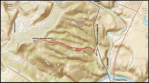 Maverick Mountain (3755) Route
 Faint Trail
 Maverick Mountain Pond
To access the old summit road from the Romey GPA parking lot, you will have to climb over the portion of the fence that is wood, at the eastern end of the lot. The photos and map posted here should help you get an idea of what to look for, since the old road is pretty hard to discern at this point. There is a small fallen steel tower that is a good reference point for sighting in the two trees to look for in finding the old road. You will head mostly north up the slope for a very short way before the trail will take a westerly bearing. In some places the road is quite well-defined, while other places it is very faint. A few locations have eroded quite a bit, making for a somewhat rough trail there. When you get near the summit, the road seems to pretty well fade away. But, you are then on a ridge of sorts, looking down at an old livestock pond. The ridge arcs around to the north and west of the pond area to the actual highpoint, which appears to have been taken over by a large tree. The hike to the summit is about 1 mile and you will gain about 600 feet in elevation.
Red Tape
As long as visitors abide by any current rules posted at the trailhead, there should be no problem. Overnight camping is not an option at this GPA. There is an overnight curfew for any kind of activities on the mountain. Campfires are not advisable either.
When to Climb
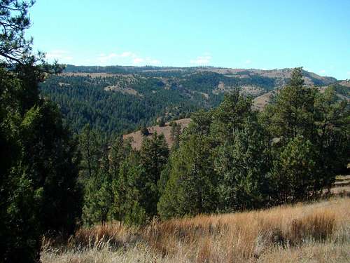 Brady Canyon
Maverick Mountain is open year-around, so unless there is a blizzard or a hail and lightning storm, most times will work for hiking. For the latest weather forecast and conditions, click on the following link: Maverick Mountain – Area Weather Forecast & Conditions Hunting seasons always warrant extra caution. Please wear plenty of bright orange if you choose to hike during one of these seasons. For more information on South Dakota hunting seasons, click on the link below: South Dakota Hunting Seasons Information
Maps
Perhaps the best maps for the area are the Black Hills South map by National Geographic and the official Black Hills National Forest map. Both are available for purchase at forest service offices and other locations in the Black Hills.
Camping & Lodging
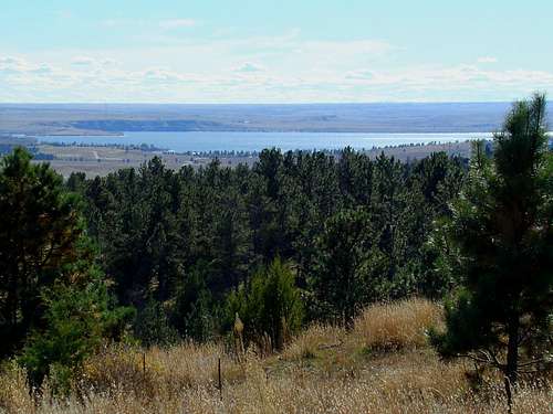 Angostura Reservoir View
Camping will need to be done at nearby campgrounds or in the nearby Black Hills National Forest lands. For more information on nearby camping and national forest camping, click on any of the links below.
Hot Springs Chamber of Commerce Camping & Lodging
The Black Hills National Forest allows back-country camping except where posted, however campfires are prohibited. You can access their camping regulations at this link:
Black Hills National Forest Back Country Camping Regulations & Information
Forest Service Information
Hot Springs District Forest Service Office
1801 Highway 18
Hot Springs, SD 57747
(605) 745-4107