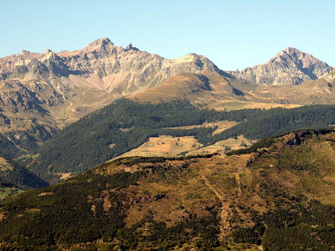
For every trip in each of them presents this trio almost unbreakable, because it represents the history, culture and traditions in the Centuries and Millennia to the firsts, and Eternity for the latest. When we think of a valley, immediately it comes to mind its highest mountain, or more beautiful that inevitably stands as a symbol of that. So for the Mont Blanc or the Grandes Jorasses in the renowned Cormayeur-Resort, Mont Velan and Grand Combins into Great St. Bernard, Cervino or Matterhorn in Valtournanche, Lyskamm Ayas, Monte Rosa in Lys Valley, Grand Paradis in Cogne and Valsavarenche, Grande Rousse to Val de Rhêmes, Sassière to Valgrisa and Rutor in La Thuile. But even those
flaunt their favorite mountain as the Grand Golliaz, Mont-de Berrio, Punte Fiorio Gorret, Arolletta,
, Viou, Faroma, Aver, Zerbion, Torché, Glacier, Rosa dei Banchi, Tersiva and Emilius. A combination that becomes even more distinctive if we add a Church, a Tower or a Castle that represent in terms Religious or what heraldic, chanting the History and the Life of the Population. One aspect that the Mountaineers,
to reach the goal and yet ignore the Hikers preferring to leave out the majesty of the views or the exclusive admiration for Nature. Fall in this way into oblivion if not in total anything despite the remaining observations that these may be the key to understand the uses and customs of a place, always a bit different from each other. A total disregard for all that has kept alive a mountain, a valley or just a country. An oversight almost incomprehensible as unforgivable that we think to regain at least part of reviving the life of the mountains, always inscrutably still in place, with that of the
Le valli hanno Chiesa, un Castello, una Torre od entrambe ed una Montagna che le contraddistiguono. Caratteristica per ciascuna di loro, valida pur per la Valle.
Infatti ogni viaggio effettuato in ognuna d'esse presenta questo trinomio quasi indissolubile, poiché rappresenta la storia, la cultura e la tradizioni nei Secoli e nei Millenni per le prime, nonché l'Eternità per le ultime. Quando pensiamo ad una valle, subito ci viene in mente la sua montagna più elevata o più bella che inevitabilmente si erge a simbolo della medesima. Così per il Monte Bianco o le Jorasses a Courmayeur, Mont Velan e Grand Combins al Gran San Bernardo, Cervino in Valtournanche, Lyskamm ad Ayas, Monte Rosa nella Valle del Lys o di Gressoney, Gran Paradiso a Cogne e Valsavarenche, Grande Rousse in Val di Rhêmes, Sassière a Valgrisa e Rutor a La Thuile. Ma anche quelle
ostentano la loro montagna preferita come Grand Golliaz, Mont-de Berrio, Punte Fiorio e Gorret, Arolletta,
, Becca di Viou, Becca d'Aver, Monte Zerbion, Becca Torché, Mont Glacier o Rosa dei Banchi e Monte Emilius. Connubio che diventa ancora più caratterizzante se acciò aggiungiamo una Chiesa, una Torre o un Castello che le rappresentino sotto il profilo Religioso oppure quello araldico, scandendo la Storia e la Vita di quella Popolazione. Un aspetto che gli Alpinisti,
di raggiungere la meta ignorano e che pure gli Escursionisti tralasciano preferendo la maestosità dei panorami o l'esclusiva ammirazione per la Natura. Cadon così nel dimenticatoio se non nell'oblio più totale le restanti osservazioni nonostante che queste possano costituire la chiave di volta per comprendere usi e costumi di una località, sempre un pò diversi l'un dall'altro. Una totale disattenzione per tutto ciò che ha tenuto in vita una montagna, una valle o semplicemente un paese. Una dimenticanza quasi incomprensibile quanto imperdonabile che pensiamo di recuperare almeno in parte riallacciando la vita delle montagne, sempre imperscrutabilmente ferme e piazzate al lor posto, con quella delle
But, in our opinion, it is the Mont Faroma with its Gothic pyramid that characterizes this valley, because who reach Lignan Hamlet not see the Becca of Luseney. Instead he sees the
Faroma (3073m) like a great Gothic cathedral from the profile and that in winter, after a recent snowfall, takes lines Himalayas with its peaks adorned by large frames snowy who smoke against the sky. This is the entry point in a valley that opens out splitting it into three parts.
a)- The first, the more Western is formed by the parallel Comba Dèche, secondary vallon with a district that goes from the Croix de Fana
(2212m), above the three Villages of Trois Villes
(1391m), the eponymous Beaks (2951m) and then continue to the North with the Eastern Tsaat a l'Etsena
(2974/5 metres about), the Pointe Joseph Marie Henry
(2918m) and Becca Conge
(2954m) before reaching the important Saint Barthélemy Hill
(2645m), which leads towards Oyace Common in Valpelline. From this point the watershed flexes more to the East and, after the little Punta Verdona
(2868m), reaches Faroma. From this a partition to the South closes this first sector, after having formed the Grand Pays and Becca di Aveille or Avouille
(2623m), above the Village Effraz
(1478m).
b)- The second is made up of a tiny vallon intermediate content to the West Coast of Champorcher
(Southern elevation 2656m, 2700m Northern) to the Col de Chaleby
(2683m); near the Col du Salvé
(2568m) separates this from rounded
Mont Morion(2709m), which forms the natural barrier between this vallon and the Basin of Cuney with its famous
Sanctuary and Refuge (2625m).
c)- The third and final part, certainly the most important, stretches from the Village of Lignan (
1633m;
Astronomical Observatory first to the Northeast to Praz Pasture
(1737m) below Col Fenêtre
(2182m), from the Torgnon Common in Valtournanche so far North, reaching, after several pastures, the final Praterier
(2060m), now at the foot of Becca's Luseney (namely between Punta Montagnaya West and Cima Bianca in opposite).
Overall, the valley, crossed by Torrent de St. Barthélemy which originates from the former glacial cirque of Becca Luseney before falling in a gorge nearby the Village of Blavy
(1015/56m), is long
about thirty kilometres, of which
about 16.2 Km. between Nus Common and the Hamlet of Lignan. Besides these two there are a dozen of them including Petit Fénis, Clemençod or Clémensod (from the Latin Clemens), Saquignod, Noz or Venoz, Le Crêt, La Combaz, Issologne (Hic Columna), or Porliod Parliou, Baravex , Praz, Arlod or dialect
"patois" Arlou (Ad Locum) and the picturesque Village of Val Deval Dessous and Dessus (Ad Vallem) before the Forest Ander below Mount Ander
(1931m) and Cima di Longhede
(2416m) on the watershed with the Basin Verrayes/St. Denis. While in locality Les Fabriques
(1411m) is the iron worked in the area. From Porliod
(1879m) to the Northeast part on the dirt road a renowned and popular trail Cross-country Skiing to La Nouva Alp
(1989m), through the Pastures of Praz de Verney and Barbonce
(2012m).
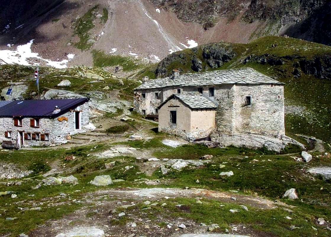
Cuney Shrine at Becca del Merlo
These two are the characteristics of this valley.
A very old story who marked his Time Religious and other "modern" looking away from her towards the immense and deep Space. You can not come in the greenesh beautiful St. Barthélemy Valley without to visit one and the other.
The "our" Holy angry very for this bad Story of the History...A)- "Complicated", that originates really, directly since the year 1000 when even the Valais Shepherds had taken refuge in this basin until the "End fel World".
Catholic Religion were the first to build a small oratory dedicated to
"Our Lady of the Heights" in what will become the Sanctuary highest in Europe. But let's calm: a landslide destroyed at that time and the same is
"saved" only a tiny wooden statue of primitive art of the Ninth Century. The event
"miraculous" upset the same that carried by the Dominican Fathers of Nus, which held up to that time the Church of Lignan. But the
Little Statue returned, like
Miracle, three times a Cuney, for which thing in 1650 the Dominican Priest Onorio decided to rebuild the ancient oratory, up there under the
Becca del Merlo. In 1661 the same, struck by the great visitation of the people, he decided to transform the same into a Chapel with an altar to celebrate Mass and the same, on the orders of the Bishop of Aosta Alberto Bailly, is dedicated to
"Our Lady of the Snows" complete with a lttle statue. But the Devil (Time) also destroyed this Chapel and the Parish Priest of St: Barthélemy, Pierre Jean Tutel, invited the locals to build a small Church stronger and resistant against bad weather. Archdeacon Luigi Porliod he completed the work and 23 August 1869 was consecrated by Bishop Jans. In 1927/1928 Don Pantaleone Petran, Lignan Pastor, with the inhabitants have built the sacristy and improved the same with rustic decorations religious inwardly, while the main altar has remained unchanged since the distant 1661. The yearly Celebration, as throughout the Valley of Aosta dedicated to the
"Madonna of the Snows", occurs on August 5th of each year.
The Devil is avenged everything disappearing with a landslide the ancient lake that once stood in nearby moraine South,
reducing the same in miserable puddle ...
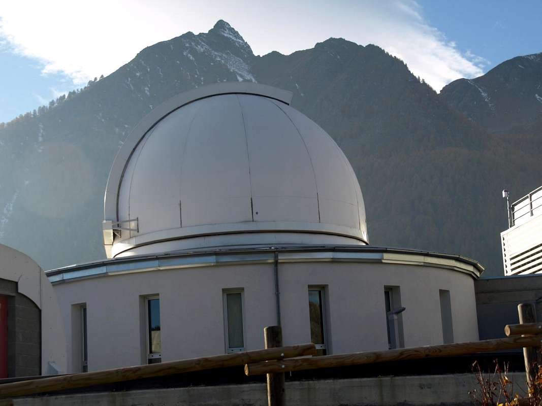
Astronomical Observatory
B)- This is instead a History more "modern" that leads to the Cosmos Search of Asteroids, Comets, Satellites, Planets, Solar Systems, Galaxies & even Aliens ...Once the people of St. Barthélemy was simpler and was content with little, climb Mont Faroma; for the most talented Luseney, where they had already passed Augusto Enrico Martelli with the Guides Jean-Antoine Carrel and Jean-Joseph Maquignaz to August 1874 and A. Adams-Reilly with the Guides Jean-Antoine Carrel and Henry Charlet in that of 1886. Sending Augustus and Ferdinand Darbelley with the Carrier Grégoire Comé Charvensod to explore in 1895 the Southeast Face of Faroma and waiting, after the passage of Captain Albert and Casalegno Surveyors of Sardinian Staff, a few English or Academic Piedmont
to complete Exploration, including the fearsome Becca del Merlo. At most, for the less skilled, he left to contemplate heaven from Mont Morion or by the Costa Champorcher, where even the cows go to graze or praying to the renowned Cuney Shrine.
But now the People had become less naive and more
"tricky". That's why they built the observatory, right here at Lignan Hamlet St. Barthélemy, where the
Sky is always clear.
The Astronomical Observatory of the Autonomous Region Valle d'Aosta (OAVdA) was inaugurated around the mid-2003 is equipped with the most modern equipment, in order to promote both the research activities of the disclosure. The property is managed, along with the planetary Lignan, Foundation Clément Fillietroz - renowned and non-profit organization, and its activity is characterized by extreme openness to the public, students, tourists, "astrolovers", to stimulate the dissemination of astronomy. At the observatory is located also the meteorological station of Nus-Saint-Barthelemy. It is located near the Village of Lignan, at
1,675 metres in the upper part of the Valley of Saint-Barthélemy, behind the town of Nus. The Village of Lignan looks like a terrace, with a low visual impact (light pollution) and characterized by a weak trend in atmospheric turbulence. For scientific research are the Observatory Astronomical active four draft institutional research ranging from studying the solar system (research and characterization of asteroids) survey on the stars of the Milky Way, the observation of distant galaxies and search for extrasolar planets. Moreover OAVdA participates, on explicit requests from other institutions in Italy and abroad, also in international collaborations for specific countries of study, taking place in well-defined periods of time depending on the celestial phenomenon to be observed and analyzed. They have designed dozens of scientific publications with peer review, which appeared in the Proceedings of important international conferences and journals of reference worldwide as Astronomy & Astrophysics, The Astrophysical Journal, Icarus, Publications of the Astronomical Society of the Pacific, The Astronomical Journal. Researchers in OAVdA between late 2011 and early 2012 were associated all'
INAF (National Institute of Astrophysics). There is also a helium physics laboratory, a classroom in which it is possible, during daytime visits, project the Sun and make various observations of the Sun group safely to the view through a telescope with a mirror of 250 mm. Laboratory is also equipped with filter H-α useful for observing special solar atmosphere phenomena in chromosphere.
![]()
Ma, a nostro avviso, é il Monte Faroma con la sua piramide Gotica che contraddistingue questa vallata, perché chi arriva a Lignan non vede la Becca di Luseney. Vede invece il Faroma
(3073 m) a guisa di grande cattedrale dal profilo gotico e che in inverno, dopo una recente nevicata, assume linee Himalayane con le sue creste adorne di grandi cornici nevose che fumano contro il cielo. Questa è la porta di ingresso in una valle che si apre a ventaglio suddividendosi in tre parti.
a)- La prima, la più Occidentale é formata dalla Comba Dèche, vallone secondario con un circondario che và dalla Croix de Fana
(2212 m), sopra i tre Villaggi di Trois Villes
(1391 m), agli omonimi Becchi
(2951 m) per poi continuare a Nord con la Tsaat a l'Etsena Est
(2974/5 metri circa), la Pointe Joseph Marie Henry e la Becca Conge
(2954 m) prima di raggiungere l'importante Colle di Saint Barthélemy
(2645 m), conducente a Oyace in Valpelline. Da qui lo spartiacque flette maggiormente ad Est e, dopo la piccola Punta di Verdona, raggiunge il Monte Faroma. Da questo un divisorio a Sud chiude questo primo settore, dopo avere scavalcato il Grand Pays e la Becca di Aveille od Avouille
(2623 m), sopra il Villaggio di Effraz
(1478 m).
b)- La seconda é costituita da un minuscolo vallone intermedio contenuto ad Ovest dalla Costa di Champorcher
(Sommità Meridionale 2656 m, 2700 m la Settentrionale) fino al Col de Chaleby
(2683 m); il vicino Col du Salvé
(2568 m) separa questa dal tondeggiante
Mont Morion (2709 m), che costituisce la barriera naturale tra questo vallone e la Conca del Cuney con il suo famoso
Santuario e Rifugio (2625 m).
c)- La terza ed ultima parte, sicuramente la più importante, si allunga dal Villaggio di Lignan
(1633 m) dapprima verso Nordest fino all'Alpe Praz
(1737 m) sotto il Col Fenêtre
(2182 m), verso il Comune di Torgnon in Valtournanche, quindi decisamente a Nord raggiungendo, dopo vari alpeggi, quello finale di Praterier
(2060 m), ormai alle pendici della Becca di Luseney ( per la precisione tra la Punta Montagnaya ad Occidente e la Cima Bianca all'opposto).
Complessivamente la valle, percorsa dal Torrent de St. Barthélemy che prende origine dall'ex circo glaciale della Becca di Luseney per poi scendere
"inforrato" verso la Frazione di Blavy
(1015/56 m), è lunga una
trentina di Kilometri, dei quali
circa 16,2 Km. tra il Comune di Nus e la Frazione di Lignan. Oltre a queste due si contano un'altra decina delle stesse tra le quali Petit Fénis, Clemençod o Clémensod (dal latino Clemens), Saquignod, Noz o Venoz, Le Crêt, La Combaz, Issologne (Hic Columna), Porliod o Parliou, Baravex, Praz, Arlod o in dialetto
"patois" Arlou (Ad Locum) ed il pittoresco Villaggio di Deval o Val Dessous e Dessus (ad Vallem) prima della Foresta di Ander sotto il Monte Ander
(1931 m) e la Cima di Longhede
(2416 m) sullo spartiacque con la Conca di Verrayes/St. Denis. Mentre in località Les Fabriques
(1411 m) si lavorava il ferro della zona. A Porliod
(1879 m) parte verso Nordest con poderale una rinomata e frequentata Pista di Fondo verso La Nouva
(1989 m), passando per gli Alpeggi di Praz de Verney e Barbonce
(2012 m).
Il Santuario del Cuney sotto la Becca del Merlo"
Queste due sono le caratteristiche di questa vallata.
Una storia antichissima che segna il suo Tempo Religioso e l'altra "moderna" che osserva lontano dal suo nell'immenso profondo Spazio. Non si può venire a Saint Barthélemy senza andare a visitare l'una e l'altra.
Il "nostro" Santo s'arrabbierebbe assai per tutta questa cattiva Storia ...
A)- Istoria "complicata" traente l'origini addirittura dall'anno 1000 quando i Pastori del Vallese s'eran rifugiati in questo bacino in attesa della "Fine del Mondo".
Di Religione Cattolica sono stati i primi a costruire un piccolo Oratorio dedicato alla
"Madonna delle Altezze" in quello che diverrà il Santuario più alto d'Europa. Ma andiam con calma: una frana distrusse a quei tempi il medesimo e si
"salvò" esclusivamente una statuetta in legno d'arte primitiva del IX° Secolo. L'evento
"miracoloso" sconvolse i medesimi che la trasportarono dai Padri Domenicani di Nus, reggenti a quell'epoca la Chiesa di Lignan. Ma la
Statuina ritornò, come per
Miracolo, ben tre volte al Cuney, per la qual cosa nel 1650 il Padre Domenicano Onorio decise di ricostruire l'antico Oratorio, lassù sotto la
Becca del Merlo. Nel 1661 il medesimo, colpito dall'enorme visitazione della gente, decise di trasformare lo stesso in una Cappella con tanto di altare onde celebrare la Messa e la stessa, su ordine del Vescovo di Aosta Alberto Bailly, fù dedicata alla
"Madonna delle Nevi" con tanto di piccola statua. Ma il Diavolo (Tempo) distrusse anche questa Cappella ed il Parroco di St. Barthélemy, Pierre Jean Tutel, invitò i locali a costruire una Chiesetta più solida e resistente contro le intemperie. L'Arcidiacono Luigi Porliod portò a termine l'opera ed il 23 Agosto 1869 avvenne la consacrazione da parte di Monsignor Jans. Nel 1927 e 1928 Don Pantaleone Petran, Parroco di Lignan, fece costruire la sagrestia e migliorò la stessa con rustiche decorazioni religiose all'interno, mentre l'altare maggiore é rimasto inalterato sin dal lontano 1661. La Festa, come in tutta la Valle d'Aosta nei confronti della
"Nostra Signora delle Nevi", ivi ricorre il 5 d'Agosto d'ogni anno.
Il Diavolo s'é vendicato di tutto ciò facendo sparire con una frana l'antico lago che sorgeva nella vicina morena Meridionale,
riducendolo a ben misera pozzanghera ...
L'Osservatorio Astronomico
B)- Questa invece é una Storia più "moderna" che porta alla Ricerca nel Cosmo di Asteroidi, Comete, Satelliti, Pianeti, Sistemi Solari, Galassie ed anche Alieni ...Una volta la gente di San Bartolomeo era più semplice e s'accontentava di poco: salire il Faroma; per i più bravi la Luseney, dove eran già transitati Augusto Enrico Martelli con le Guide Jean-Antoine Carrel e Jean-Joseph Maquignaz ad Agosto 1874 ed A. Adams-Reilly con le Guide Jean-Antoine Carrel ed Henry Charlet in quello del 1886. Mandando Augusto e Ferdinando Darbelley col portatore Grégoire Comé di Charvensod ad esplorare nel 1895 la Parete Sudest del Faroma ed aspettando, dopo il passaggio del Capitano Albert e Casalegno Topografi dello Stato Maggiore Sardo, qualche Inglese o gli Accademici Piemontesi
per completar l'Esplorazioni, compresa la temibile Becca del Merlo. Al massimo, pei men bravi, rimaneva per contemplare il cielo il Mont Morion o la Costa di Champorcher, dove van pascolar pur le mucche, oppure pregando al Santuario del Cuney.
Ora le Gente era diventata meno ingenua e sempre più
"difficile". Ecco perché han costruito l'Osservatorio, proprio qui a Lignan di St. Barthélemy, ov'il
Cielo é sempre limpido.
L'Osservatorio Astronomico della Regione Autonoma Valle d'Aosta (OAVdA) è stato inaugurato a circa la metà del 2003. È equipaggiato con le più moderne strumentazioni, al fine di favorire sia l'attività di ricerca che quella di divulgazione. La struttura è gestita, insieme al planetario di Lignan, dalla Fondazione Clément Filliétroz - Onlus, e la sua attività è caratterizzata da un'estrema apertura al pubblico, agli studenti, ai turisti, agli astroamatori, per stimolare la divulgazione dell'astronomia. Presso l'osservatorio si situa anche la stazione meteorologica di Nus-Saint-Barthélemy. Si trova vicino al Villaggio di Lignan, a
1675 metri, nella parte alta del Vallone di Saint-Barthélemy, a monte del capoluogo di Nus. La frazione di Lignan si presenta come una terrazza naturale, a ridotto impatto luminoso (inquinamento luminoso) e caratterizzata da una debole tendenza a turbolenze atmosferiche. Per la ricerca scientifica nell'Osservatorio Astronomico sono attivi quattro progetti di ricerca istituzionali che spaziano dallo studio del sistema solare (ricerca e caratterizzazione di asteroidi) all’indagine sulle stelle della Via Lattea, l’osservazione delle galassie lontane e ricerca di pianeti extrasolari. Inoltre l’OAVdA partecipa, su esplicite richieste di altri istituti in Italia e all’estero, anche a collaborazioni internazionali per specifiche campagne di studio, che si svolgono in periodi ben determinati di tempo a seconda del fenomeno celeste da osservare e analizzare. Sono state prodotte alcune decine di pubblicazioni scientifiche con peer review, comparse negli atti di importanti congressi internazionali e su riviste specializzate di riferimento a livello mondiale come Astronomy & Astrophysics, The Astrophysical Journal, Icarus, Publications of the Astronomical Society of the Pacific, The Astronomical Journal. I ricercatori in OAVdA tra la fine del 2011 e l’inizio del 2012 sono stati associati all’
INAF (Istituto Nazionale di Astrofisica). Anche un laboratorio eliofisico, un'aula didattica nella quale è possibile, durante le visite diurne, proiettare il Sole e svolgere osservazioni di gruppo del Sole in piena sicurezza per la vista tramite un telescopio con specchio da 250mm. Inoltre il laboratorio è dotato anche di filtro H-α utile per l'osservazione della cromosfera solare.