


-
 2014 Hits
-
 77.48% Score
-
 8 Votes
|
|
Area/Range |
|---|---|
|
|
45.58080°N / 7.47101°E |
|
|
Hiking, Mountaineering |
|
|
Summer, Fall |
|
|
10052 ft / 3064 m |
|
|
Note
La montagna chiama i suoi figli, ed essi rispondono fedelmente al suo appello… Osvaldo Cardellina, Diario alpinistico, 1964-65 Page texts: @ OsvaldoCardellina "Osva", passed away on May 2, 2022. Page owners: Christian Cardellina e Osvaldo Cardellina. Any updates from September 12, 2022: Antonio Giani, page administrator, friend and climbing companion. Testi della pagina: @ OsvaldoCardellina "Osva", scomparso il 2 maggio 2022. Proprietari pagina: Christian Cardellina e Osvaldo Cardellina. Eventuali aggiornamenti dal 12 settembre 2022: Antonio Giani, amministratore della pagina, amico e compagno di salite. |
Overview
Miserino it does not correspond to Miserin. The root is common, but while the first is located into Vallon of Urtier in Cogne Valley , the second is located in the adjoining Valley Champorcher. The Hill Fenêtre connects these two in a short time allowing the passage. But the transit between the two centers of population and Lillaz Dondena is somewhat distant, not to mention the descent Château Champorcher, the Cief Town. This name bears witness of the labors and hardships of those people in the past that the "Misery" united in daily living. But it also has appurtenances latin with the "Miserere", or seeking forgiveness for the sins and human injustice. Anticipating far "Les Miserables" by the Novelist Victor Hugo. That's why the Miserin, at the namesake lake, was built in 1658, by Pantaleon Savin, the Sanctuary Notre-Dame-des-Neiges above the ancient chapel famous for miracles performed during the terribly nefarious "Plague of 1630".
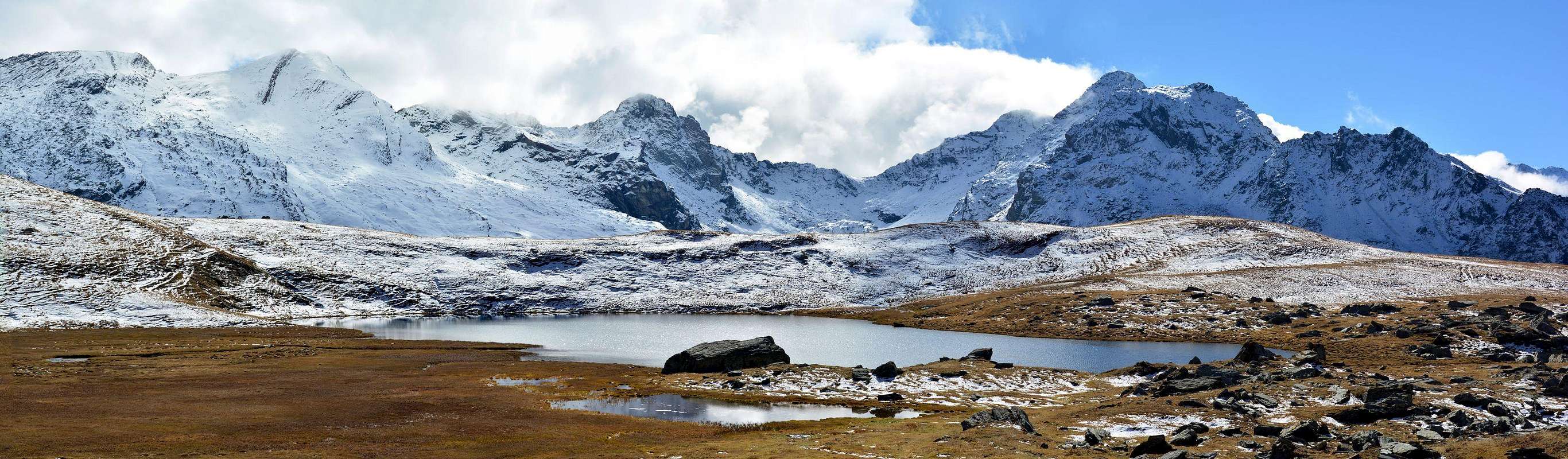
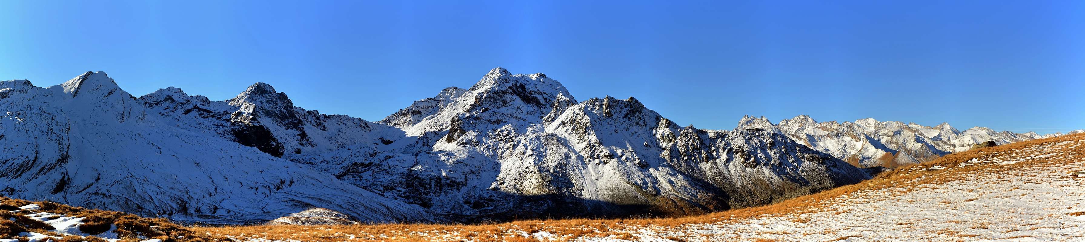
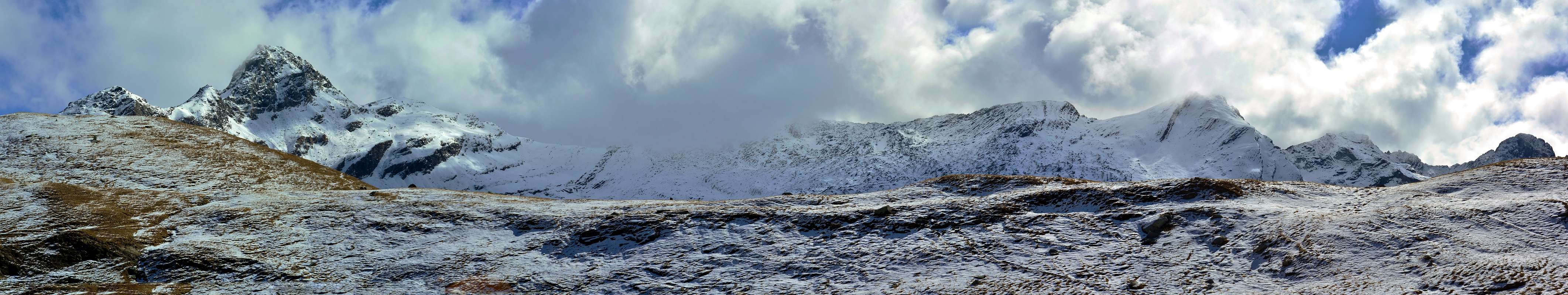
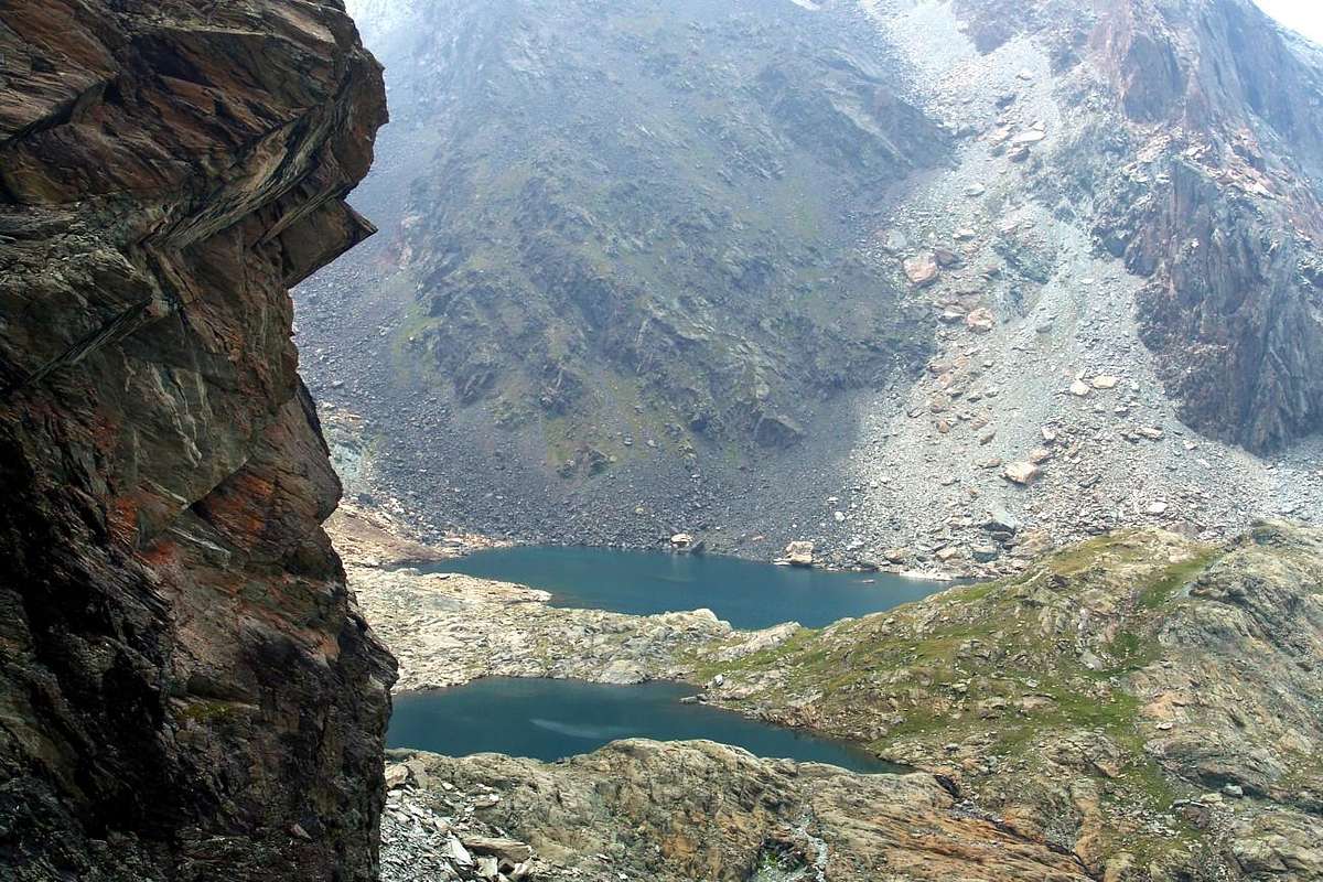
Instituted a Procession still in vogue, the 5th August Month. Nowadays, dominated Science and Rationality, one would say only that they were not true Miracles , but simply redeeming those that salt upward to breathe the pure air of the Rosa dei Banchi drinking water uncontaminated Torrent Ayasse. However, after 150 years, became famous also for the inhabitants of Cogne and Campiglia Soana in Canavese (Piedmont) and the King of Italy Vittorio Emanuele II° was upwards from Dondena Sunday, in order to attend the Mass. Even these last two populations instituted a Procession route, but with backward going to San Besso in the nearby Walloon of Rancio above Campiglia and Valprato Soana. Traditional destination for meetings between the two valleys on August 10th, even today. But to transit was not used and not using the Colle del Miserino, at the end of this basin, but that immediately adjacent to the East of the Arietta. In this basin occurs, for those who are sensitive, even the "Rite of Purification with Water" hence the name, thanks to the presence of two beautiful small lakes at the feet of the district that embraces them between Testa dell'Arietta (Head of Small Air), and Punta of Miserino and homonym Pass, Punta della Scaletta and Nera. Have nothing to envy to the largest Miserin, indeed their banks propagate a sense of Peace and Spirituality even greater.
The Vallons most important & the recommended Excursions (4)
 |
Small Historical Note
 |
Il Miserino non é il Miserin. La radice é comune, ma mentre il primo trovasi nel Vallone d'Urtier in Val de Cogne, il secondo è sito nell'attigua di Champorcher. Il Colle Fenêtre collega questi due permettendo in breve tempo il passaggio. Ma il transito tra i due centri abitati di Lillaz e Dondena è alquanto distante, per non parlar della discesa a Château di Champorcher, il Capoluogo. Questo toponimo testimonia delle fatiche e degli stenti di quelle popolazioni nel Passato che la "Miseria" univa nel viver quotidiano. Ma possiede anche attinenze latineggianti con il "Miserere", ovvero la ricerca del perdono per i peccati e l'umane ingiustizie. Anticipando di gran lunga "Les Miserables" di Victor Hugo. Ecco perché al Miserin, presso l'omonimo Lago, é stato costruito nel 1658, da parte di Pantaleone Savin, il Santuario di Notre-Dame-des-Neiges al di sopra dell'antica cappella famosa per i Miracoli compiuti durante la "Peste del 1630". Istituirono una Processione ancor oggi in auge, il 5 del mese di Agosto. Oggigiorno, dove dominano la Scienza e la Razionalità, si direbbe soltanto che non eran Miracoli, ma semplicemente si salvava chi salisse a respirar l'aria pura della Rosa dei Banchi bevendo l'acqua incontaminata del Torrent Ayasse. Comunque, dopo 150 anni, diventò famoso anche per gli abitanti di Cogne e di Campiglia Soana in Canavese (Piemonte) e lo stesso Re d'Italia Vittorio Emanuele II° si recava da Dondena la Domenica, onde assistere alla S. Messa. Anche queste due ultime popolazioni istituirono una Processione, ma con percorso a rovescio recandosi a San Besso nel vicino Vallone del Rancio sopra Campiglia e Valprato Soana. Punto d'incontro, ancor oggi, del 10 d'Agosto tra le due vallate. Ma per transitare non s'usava e non s'usa il Colle del Miserino, al termine di questa conca, bensì quello subito attiguo ad Oriente dell'Arietta. In questo bacino ricorre, per chi é sensibile, anche il "Rito della Purificazione con l'Acqua" donde il nome, grazie alla presenza di due splendidi laghetti posti ai piedi del circondario racchiudentili tra Testa dell'Arietta, Punta del Miserino e Colle, Punta della Scaletta e Punta Nera. Nulla han da invidiar all'esteso Miserin, anzi le lor sponde propagano un senso di Pace e di Spiritualità ancor maggiore.
Noterella Storica:
Nel XVII° Secolo venne edificato il rinomato Santuario dedicandolo a San Besso; fu completato nel 1669 ed importanti restauri avvennero nel 1857 e nel 1985. Se venite da queste parti, ciò é ciò che trovate. Non pensate a grandi arrampicate su roccia solidissima ma piuttosto ad una bell'Escursione. Anche qui é già passato George Yeld nel 1912 insieme alle sue Guide di Valtournanche Beniamino ed Anselmo Pession per salir la Cresta Nordovest della Punta Nera. Preceduto di due giorni soltanto da R.I.G. Irving e H.E.G. Tyndale che il 10 di Agosto avevan effettuato la prima ascensione assoluta della Punta della Scaletta attraversando la medesima da Est verso Nordovest. Ma prima ancora erano passati Carlo Ratti ed Ercole Daniele, il 22 Luglio 1896, per fare la prima della Punta del Miserino, ed ancor prima, il 13 Luglio 1880, il Capitano Cloza per salire coi suoi soldati del Genio la Punta Nera. E prima ancor di prima? Il Tempo, come dimostrano i variopinti colori di queste antichissime pietre trasformate dal vento, dall'acqua e dai ghiacci. Poi siam passati noi, molto tempo dopo ed ancor qualcosa di buono, più o meno, abbiam pur combinato. Certamente non passeremo alla Storia per quanto compiuto, ma pur sempre era qualche cosa di nuovo dopo tanti anni di silenzio assoluto. Sempre meglio che niente, sempre meglio che qui arrivar solamente per sdraiarsi a prender il sole. Allora non riman più nulla? Sempre qualcosa c'é per chi sà cercar ...
 |
Getting There
BY CAR:
- From TORINO, MILANO, etc: Motorway A5. Exit at IVREA or Quincinetto (PIEDMONT) AOSTA West/Aymavilles, Cogne Municipalities.
- Specific Roads From Aymavilles Municipality (646m) towards Cogne Valley progressively reaching the Hamlets of Vieyes (1.158m), Epinel (1.436m), Crétaz (1.494m) until Cogne Common (1.563m). From this in East through the Regional Road (7,5 Km.) to arrive at Lillaz Fraction (1.607m), passing near Champlong (1.596m) Village. Take the farms dirt road towards "Sogno di Berdzé" Refuge at Peradzà Alp in Urtier Vallon, under the Fenêtre of Champorcher. Reach the junction 2.363 meters on dirt road, after turn South to the Broillot or Broillà Alp (2.399m) at the feet and just at entrance on Miserino's Conca.
- From FRANCE: through the Mont Blanc Tunnel to Entrèves-crossroads to Vény/Ferret Valleys - Mountain Guides of Courmayeur - La Saxe Rock Gym - Courmayeur. By Little Saint Bernard Hill, closed since November until half May to La Thuile Valley - Pré Saint Didier - Courmayeur. It is not necessary to take Motorway A5: you can drive on SS.26, in the direction of AOSTA - IVREA - TURIN.
BY PLANE:
- Aeroporto "Corrado Gex" Saint Christophe (Aosta).
Some Hiking Routes Easy
1) - Lillaz Hamlet, Goilles Damon, Tsavanis Pastures (1.607m, 1.869m, 2.293m), fork 2.363 meters, Broillot Alpage (2.399m): Excursion with trails 13A/13B before in East, after on small path 13C South-southeast to two Miserino's Lakes (2.664m, 2.665m), amongst Punta Miserino, Punta della Scaletta and Punta Nera (E/F; 3h'00/3h'30).
2) - To Miserino's Lakes: Excursion from Lillaz with path before in East-southeast to Alp Broillot, after in South to Miserino Lakes and Pass (2.842m) (EE/F; 4h'00/4h'20).
3) - Towards Saddle 2.897 meters and Tête de la Nouva (3.034m): Excursion-Climbing from Miserino Lakes, dubling the Northern Slope, to Saddle 2.897 meters and through East-northeast Ridge, avoiding left (South) a certain amount of short rocky steps crossing on grassy ledges, to Tête de la Nouva (3.034m) (EE/A/F+; 1h'30/1h'45).
4) - To Colle dell'Arietta (2.947m) and Tête de l'Arietta (2.998m): Excursion-Climbing from Miserino Lakes, dubling the North Slope of Punta del Miserino with path 13B/VA, to Testa dell'Arietta and through East-northeast Ridge. Also with route more in West from the Eastern Loch towards the pond 2.858 meters, below Punta del Miserino Testa dell'Arietta, and from this towards Arietta's Pass, without path but crossing on Northern Crest Pointe Miserino and through wild moraines (EE/A/F+; 1h'15/1h'30).
5) - Lakes to Miserino Pass (2.842m): Excursion from the junction between two lakes in South pathless but moraines towards Miserino Pass (EE/A/F+; 1h'00/1h'15).
 |
 |
 |
6) - Lakes to Pass and Punta del Miserino (3.010m): Excursion-Climbing from lakes towards Punta del Miserino, through West-southwest Ridge (EE/A/F+; 1h'00/1h'15).
7) - Western Lake to "Bocchetta of Punta Nera" or saddle (2.980m) and Punta della Scaletta or Pointe d'Echellette (3.018/20m): Excursion-Climbing from Lillaz with path before in East to Alp Broillot, after Southeast and South to Miserino Lakes. Starting from Western Lake through very steep moraines and brocken blocks, pathless, to a small carving about 2.980 meters. Through Northern Ridge in final part, crossing on acute little spires very sharp (I°+/II°-), towards Punta Scaletta (EE/A/F+; 2h'30/2h'45).
8) - Lakes to saddle (2.980m) and Punta Nera (3.063/4m): Excursion-Climbing from Lillaz with path before in East to Alp Broillot, after Southeast and South to Miserino Lakes; from Western Lake through steep moraines to a small carving about 2.980 meters. Through Northern Ridge in terminal part to Punta Nera (EE/A/F+; 2h'00/2h'15).
Campings
Remember that free camping is forbidden (except for emergency reasons, over 2.500m, from darkness until dawn).Mountain Conditions
- You can get meteo information at the official site of the Regione Valle d'Aosta:
- Valle d'Aosta Meteo
Books and Maps
BOOKS:- "Guida delle Alpi Occidentali" di Giovanni Bobba e Luigi Vaccarone C.A.I. Sezione di Torino Volume II (parte II), 25 Maggio 1896.
- "Guida dei Monti d'Italia–Emilius Rosa dei Banchi Parco del Mont Avic" di Giulio Berutto e Lino Fornelli-Club Alpino Italiano/Touring Club Italiano, Marzo 2005 (in Italian).
- "I Rifugi della Valle d'Aosta" di Stefano Ardito, Ed. Guide iter, Febbraio 2003.
- "Guida della Regione Autonoma Valle d'Aosta" di Mario Aldrovandi; Ed. S.P.E. di Carlo Fanton, Torino 1964.
 |
 |
 |
 |
MAPS:
- Enrico Editore Ivrea-Aosta "Gruppo del Gran Paradiso" 1:50.000.
- I.G.C. Istituto Geografico Centrale Torino "Ivrea Biella e Bassa Valle d’Aosta" (n° 9), 1:50.000.
- L'Escursionista "Valle di Cogne Carta dei Sentieri" 1:25.000.
Important Information
- REGIONE AUTONOMA VALLE D'AOSTA the official site.
- FONDAZIONE MONTAGNA SICURA Villa Cameron, località Villard de la Palud n° 1 Courmayeur (AO) Tel: 39 0165 897602 - Fax: 39 0165 897647.
- SOCIETA' GUIDE ALPINE DI COGNE Tel. 347/9473526 – 328/1373728.
- A.I.NE.VA. (Associazione Interregionale Neve e Valanghe).
Useful Numbers
- Protezione Civile Valdostana località Aeroporto n° 7/A Saint Christophe (Ao) Tel. 0165-238222.
- Bollettino Meteo (weather info) Tel. 0165-44113.
- Unità Operativa di Soccorso Sanitario Tel. 118.