Visiting Valpelline-Oyace-Bionaz & "Tour de la Tornalla": a walk a hike & one ascent

Visiting Valpelline-Oyace-Bionaz & "Tour de la Tornalla": a walk a hike & one ascent

Page Type Page Type: Trip Report
Location Lat/Lon: 45.89812°N / 7.49102°E
Date Date Climbed/Hiked: Sep 12, 2015
Activities Activities: Hiking, Mountaineering, Trad Climbing
Seasons Season: Spring, Summer, Fall, Winter

Tour & Dam Overview


All valleys have Church, Castle or Tower and even both or a Mountain with hallmarks. Characteristic for each that applies even to whole, complete Aosta Valley.
For every trip in each of them presents this trio almost unbreakable, because it represents the history, culture and traditions in the Centuries and Millennia to the firsts, and Eternity for the latest. When we think of a valley, immediately it comes to mind its highest mountain, or more beautiful that inevitably stands as a symbol of that. So for the Mont Blanc or the Grandes Jorasses in the two Courmayeur Vény and Ferret Valleys, Mont Velan and Grand Combins into the Great St. Bernard, Matterhorn in Valtournanche, Lyskamm in Ayas, Monte Rosa at the Lys Valley, Grand Paradis in Cogne and Valsavarenche, Grande Rousse to Val de Rhêmes, Sassière to Valgrisa and Rutor in La Thuile. But even those "minor" flaunt their favorite mountain as the Grand Golliaz, Mont-de Berrio, Punte Fiorio Gorret, Arolletta, Becca de Luseney, Viou, Faroma, Aver, Zerbion, Torché, Glacier, Rosa dei Banchi, Tersiva and Monte Emilius. A combination that becomes even more distinctive if we add a Church, a Tower or a Castle that represent in terms Religious or what heraldic, chanting the History and the Life of the Population. One aspect that the Mountaineers, "hasty" to reach the goal and yet ignore the Hikers preferring to leave out the majesty of the views or the exclusive admiration for Nature. Fall in this way into oblivion if not in total anything despite the remaining observations that these may be the key to understand the uses and customs of a place, always a bit different from each other. A total disregard for all that has kept alive a mountain, a valley or just a country. An oversight almost incomprehensible as unforgivable that we think to regain at least part of reviving the life of the mountains, always inscrutably still in place, with that of the People who live at the base of the same, being born here, living and ending their journey ...


Mont Morion Meridional (3505m) Southeast Face from Valpelline, by Osw 2016


Le valli hanno Chiesa, un Castello, una Torre od entrambe ed una Montagna che le contraddistiguono. Caratteristica per ciascuna di loro, valida pur per la Valle.
Infatti ogni viaggio effettuato in ognuna d'esse presenta questo trinomio quasi indissolubile, poiché rappresenta la storia, la cultura e la tradizioni nei Secoli e nei Millenni per le prime, nonché l'Eternità per le ultime. Quando pensiamo ad una valle, subito ci viene in mente la sua montagna più elevata o più bella che inevitabilmente si erge a simbolo della medesima. Così per il Monte Bianco o le Jorasses a Courmayeur, Mont Velan e Grand Combins al Gran San Bernardo, Cervino in Valtournanche, Lyskamm ad Ayas, Monte Rosa nella Valle del Lys o di Gressoney, Gran Paradiso a Cogne e Valsavarenche, Grande Rousse in Val di Rhêmes, Sassière a Valgrisa e Rutor a La Thuile. Ma anche quelle "minori" ostentano la loro montagna preferita come Grand Golliaz, Mont-de Berrio, Punte Fiorio e Gorret, Arolletta, Becca di Luseney, Becca di Viou, Monte Faroma, Becca d'Aver, Monte Zerbion, Becca Torché, Mont Glacier o Rosa dei Banchi e Monte Emilius. Connubio che diventa ancora più caratterizzante se acciò aggiungiamo una Chiesa, una Torre o un Castello che le rappresentino sotto il profilo Religioso oppure quello araldico, scandendo la Storia e la Vita di quella Popolazione. Un aspetto che gli Alpinisti, "frettolosi" di raggiungere la meta ignorano e che pure gli Escursionisti tralasciano preferendo la maestosità dei panorami o l'esclusiva ammirazione per la Natura. Cadon così nel dimenticatoio se non nell'oblio più totale le restanti osservazioni nonostante che queste possano costituire la chiave di volta per comprendere usi e costumi di una località, sempre un pò diversi l'un dall'altro. Una totale disattenzione per tutto ciò che ha tenuto in vita una montagna, una valle o semplicemente un paese. Una dimenticanza quasi incomprensibile quanto imperdonabile che pensiamo di recuperare almeno in parte riallacciando la vita delle montagne, sempre imperscrutabilmente ferme e piazzate al lor posto, con quella delle
Genti che vivono alla base delle medesime, qui nascendo, vivendo e concludendo il loro cammino ...


Arolletta Chain above Ruz-Dzovenno (Bionaz), by Osw 2015


After visiting the hill over the course of Baltea, we move to the Northeast in Gr. St. Bernard and his branch more Eastern by Valpelline facing up to the Bionaz.
A "wild and unspoiled" valley after which even the great Place Moulin dam not disturbs the landscape. Perhaps even it enhances it, like a large lake into which reflect ancient and "historical" mountains like the beautiful pyramid of Becca di Luseney while in the background stand out against the sky Grandes Petites Murailles, heralding the great Glacier of Tsa de Tsan. A beautiful Hike, you can reach the beginning of the artificial lake along the dirt road concurrent with the trail n° 9/10/11/12/13 along its Northern shore and, after the visit with the Promenade towards Tornalla's Tour, just after the Chapel of La Lè Novailloz (2021m) to the Alp Praz Raye (2021m), above the Refuge Prarayer (1988m; T/E/F; 1h'00/1h'15). Otherwise you can think of an easy hike to a nearby Summit, perhaps starting from Valpelline to the great forests facing South.


Becca Luseney (3513m) West Face between North & South Ridges, by Osw 2015


No one forbids or prevents you from doing a "jump" to the nearby Becca Viou for Arpisson Vallon or Faroma by Comba Vessona, both from here in full view ...
1)-
One continuing with the path to the Tour de la Tornalla to the junction 1390 metres to go down to the bridge through the under Betenda diversion with the trail n° 3. By Betenda (1356/51m) continue on to the South with route n° 5/Alta Via n° 1 which goes along the entire Vessona Valley reaching the hill of the same name (2788m). From this via the Northeast Ridge easily overcoming a brief "mauvais pas" in the middle of it, then though broken rocks or blocks to the Summit (3073m; EEA/F+; 5h'45/6h'15).
2)- Alternatively, starting first from Valpelline, through the bridge after Prailles (942m) on Buthier de Valpelline you can search the whole Comba of Arpisson along the trail n° 5, first concurrent with the farm dirt road that reaches the alp with the same name (1838/82m). Abandoning to the left after the detour to Fouillou Pass, it goes back to the South reaching, through Porillon Alpe-Neuve Alp, with the trail n° 20A/20B/105 first towards Arpisson Lake (2484m) and then to the next Viou Hill (2696/8m), at the Penne Nere Bivouac (2730m). A simple Crest East-southeast, with a small track on easy small rocks under the tread, leads quickly to Becca Viou (2856m; E/F; 5h'45/6h'15).


Gran Becca & Pointe du Bachà just above Bionaz, by Osw 2015


Dopo la visita alla collina sopra il corso della Dora, ci spostiamo più a Nordest verso il Gran San Bernardo ed il ramo Orientale rivolto alla Valpelline sin a Bionaz.
Una valle "selvaggia ed incontaminata" al termine della quale nemmeno la grande Diga di Place Moulin disturba il paesaggio. Anzi forse lo esalta, come fosse un grande lago nel quale si rispecchiano antiche e "storiche" montagne come la bella piramide della Becca di Luseney mentre sullo sfondo si stagliano contro il cielo Grandes e Petites Murailles, che preannunciano il grande Ghiacciaio di Tsa de Tsan. Una bella Escursione, dopo la visita Passeggiata alla Tour de la Tornalla, permette di raggiungere l'inizio del lago artificiale percorrendo la strada poderale concomitante con il sentiero n° 9/10/11/12/13 lungo la sua sponda Nord e, dopo la Cappella di La Lè a Novailloz (2021 m) fino all'Alpe Praz Raye (2021 m), appena sopra il Rifugio di Prarayer (1988 m; T/E/F; 1h'00/1h'15). Altrimenti si può pensare ad una facile Ascensione ad una Cima dei dintorni.
Nessuno vieta od impedisce di fare un "salto" alla vicina Becca di Viou per l'Arpisson od al Faroma per la Comba di Vessona, entrambe da qui ben in vista ...
1)-
Una continuando con il sentiero verso la Tour de la Tornalla fino al bivio 1390 metri per scendere al Ponte della Betenda tramite la deviazione sempre con sentiero n° 3; dalla Betenda (1356/51 m) continuare a Sud con il sentiero n° 5/Alta Via n° 1 che percorre l'intero Vallone di Vessona raggiungendo lo omonimo colle (2788 m). Da questo tramite la facile Cresta Nordest superando un breve "mauvais pas" a metà della medesima, quindi con rocce rotte e blocchi e poi alla Vetta (3073 m; EEA/F+; 5h'45/6h'15).
2)- In alternativa, partendo dal primo Comune di Valpelline, dal ponte dopo Prailles (942 m) sul Buthier de Valpelline si può percorrere l'intera Comba di Arpisson tramite il sentiero n° 5, dapprima concomitante con la strada poderale, che raggiunge l'omonima alpe (1838/82 m). Lasciata subito dopo sulla sinistra la deviazione per il Colle di Fouillou, si risale verso Sud raggiungendo, passando per Porillon Alpe-Neuve, con il sentiero n° 20A/20B/105 dapprima il Lago d'Arpisson (2484 m) ed il successivo Colle di Viou (2696 m), presso il Bivacco Penne Nere (2730 m). La semplice Cresta Est-sudest con una piccola traccia conduce in breve tempo alla Becca di Viou (2856 m; E/F; 5h'45/6h'15).

Oyace ... Bca de Viou & Voyfrède Northern Faces 2015
Bionaz ... By Lexert Loch to Jumeaux & Tour Noir 2015
Lac Lexert between Oyace/Bionaz & Gr. Murailles 2015
Bionaz ... Gran Bca Pointe du Bachà & Invergnaou 2015


From Oyace/Bionaz to Becca de Viou, Lexert Lake, Gran Becca Pointes du Bachà & Invergnaou, by Osw 2015


Getting There

By car:

  • From TORINO, MILANO, etc: Motorway A5. Exit at IVREA or Quincinetto (PIEDMONT)

    From IVREA Town: before in West to Aosta, after in Northeast towards Gignod, Valpelline, Oyace and Bionaz Municipalities.

    From Courmayeur Resort: before in East to Aosta, after in Northwest to Gignod and in Northeast towards Valpelline, Oyace and Bionaz Municipalities.


    From Valpelline towards Oyace and Bionaz Communes in Valpelline Valley
    From Valpelline (580m), with Regional, to Oyace Common (1316-1377m); this to North and South Vallons (Brison, Crête Sèche, Vertsan, Tsa Comba, Grand Chamin Comba, Comba des Lacs and d'Orein up to the entrance into the vallon between Gran Vanna-Braoulé-Bouquetins and Petite/Grande Murailles, below Valpelline Pass.
    From Oyace (1377m), with Regional Road, to Bionaz Commune (1612m) and Places Moulin artificial Dam (1970/80m) and Northern and Southern Vallons (Bella Tsa, Combes de Valcornière, Livourneaz, Montagnayes; Vessonaz, Verdonaz, Vieille, Verdzignolaz, Arpisson, Gran Comba and Roisan-Praperiaz Basin. In North: above Ruz Crêtes Sèches Refuge (2389m) under Arolletta small crest and Mont Berlon and Franco Spataro Bivouac (2600m); above Chamen or Chamin Sassa's Bivouac (2973m). From Praz Raye with the Prarayer Refuge (2005m) in Comba d'Orein Nacamouli Refuge (2828m) and Col Collon Bivouac (2818m) at Collon Pass. Towards North: "Capanna" Aosta (2788) at Dent d'Hèrens; North-northeast: Perelli Bivouac (3831m) on Col des Grandes Murailles. East-northeast: Bivouac de la Tête des Roèses (3170m) below the Grandes Murailles and over Paoluccio Bivouac (3582m). East: Fiorio Bivouac (3307m) at Col de Creton. From Oyace or from Valpelline In South or Southeast: Lière Bivouac (2423m) nearby the Arpeyssaou Hill. Valpelline in South-southeast: "Penne Nere" Bivouac (2730m) near Viou Hill and Becca.


    "Place des Moulins" Dam, by Osw


  • From FRANCE: through the Mont Blanc Tunnel to Entrèves-crossroads to Vény/Ferret Valleys - Mountain Guides of Courmayeur - La Saxe Rock Gym - Courmayeur. By Little Saint Bernard Pass, closed since November until half May to La Thuile Valley - Pré Saint Didier - Courmayeur.

    It is not necessary to take Motorway A5: you can drive on State Road n° 26, in the direction of AOSTA - IVREA - TURIN.


By plane:

  • Aeroporto Internazionale "Corrado Gex" Saint Christophe (Aosta).


Hike towards Tornalla's Tower


Towards Valpelline, Oyace and Bionaz


A choice is that from the junction on the main road of Moulin (777/65m) after Roisan Commune (643m), reached as mentioned also by the Hamlet of Senin near St. Christophe Municipality, rather than the San Bernardo there shall Northeast towards the "wild" Valpelline, composed of three Commons Valpelline, Oyace and Bionaz until you reach the Dam of "Place Moulin or des Moulins" over there to the Grandes Murailles Dent d'Herens at the border with the Valtournanche or Valley of the Matterhorn.
Connection variant:
it is also possible to "bind" the two routes through the return from San Bernardo to the Municipalities of Allein (1253m) and Doues (1251m) with steep but short descent from the latter to Valpelline (938m). Otherwise from the crossroads of Moulin continuing on Regional Road next to the Torrent Buthier you first reach the village of Rhins (785m). *** Even from here with Road Regional towards Doues) and little ones of Collin, Avillier, Creusevy, Chanodaz, Liarey (+; 904m) and Valpelline center.
This valley, in turn, gives two opportunities: 1)- Valpelline just after the junction 1029 metres between Cleyval and Chosoz take toward North Regional Road to Ollomont Commune (1356m), just below the By Basin. Otherwise 2)- continue to Est-northeast, with the Regional Road in the direction of the upper-middle part of the valley, reaching Villages Lavod, Berrio, Thoules (+; 1045m) and the Oyace Common (1316m), at the foot of the Mountain Chain Mont Morion and dominated by the dark Tour d'Oyace (1474m). The last part of this secluded valley and wild moves towards Bionaz with the gigantic dam of the same name, also known as the Places de Moulin. Oyace by the Regional reaches the Villages Serignan, Close, Place, Balme (1515m)), the Lexert Lake (1552m) with its small "Area Naturalistic" Dzovenno (1564/77m), Perquis and Bionaz (1622m). From there reaches Ferrère, Chamin, Léchère (1812m) small Villages to finish at Place Moulin or Place des Moulins (1980m) to West front of the Place des Moulins Dam. But it is also possible to completely this big stage in a single day traveling by car all the ways indicated. Watching the whole thing "in passing", but also renouncing to up some short and pleasant walk on foot, for example in 1934, in the footsteps of Abbé Henry and Princess Maria José with its "Queen of the Society or Chaperon" towards the Chapel of Les Thoules Dessus smoking cigar and cigarettes until late at night, after being gone from Dessous Thoules, Grand Chemin, Lavod, Simon and Les Ansermins Villages.
Abbot says in Diary: "At the patron saint of the Thoules Chapel there are always firefighters ...". We reply, 82 years after: "Of course, with all these smokers ....


Verso Valpelline, Oyace e Bionaz


Una scelta consiste che dal bivio sulla Statale di Moulin (777/65 m) dopo il Comune di Roisan (643 m), raggiungibile come già detto anche dalla Frazione di Senin presso il Comune di St. Christophe, invece che a Nordovest pel San Bernardo si proceda a Nordest verso la "selvaggia"Valpelline, composta dai tre Comuni di Valpelline, Oyace e Bionaz sin a raggiungere la Diga di "Place Moulin o des Moulins" là in fondo verso Grandes Murailles e Dent d'Hérens al confine con la Valtournanche o Valle del Cervino.
Variante di collegamento:
inoltre é possibile "legare" i due itinerari passando al ritorno dal San Bernardo per i Comuni di Allein 1253 m) e di Doues (1251 m) con ripida ma breve discesa da quest'ultimo a Valpelline (938 m). Altrimenti dal bivio di Moulin continuando sulla Strada Regionale a fianco del Torrent Buthier si raggiunge dapprima il Villaggio di Rhins (785 m). *** Anche da qui Strada Regionale per Doues) e poi quelli di Collin, Avillier, Creusevy, Chanodaz, Liarey (+; 904 m) ed il centro del Comune di Valpelline.

Oyace ... Tour Tornalla above St. Michel Church 2015
Oyace ... At the beginning of trail to Tornalla 2015
Oyace ... Middle part of path to Tornalla Tower 2015
Oyace ... Upper part above Betenda Tableland 2015
Exist ... trail from Tornalla Tower up Betenda Plain 2015


From Oyace nearby the Village of Serignan-Chez les Bredy the trail towards Tour de la Tornalla, by Osw 2015


Questa valle, a sua volta, concede due opportunità: 1)- subito dopo Valpelline al bivio 1029 metri tra Cleyval e Chosoz prendere verso Nord la Strada Regionale per Ollomont (1356 m), subito al di sotto della Conca di By. Oppure 2)- continuare verso Est-nordest con la Regionale in direzione della parte medio-alta della vallata raggiungendo i Villaggi di Lavod, Berrio, Thoules (+; 1045 m) ed il Comune di Oyace 
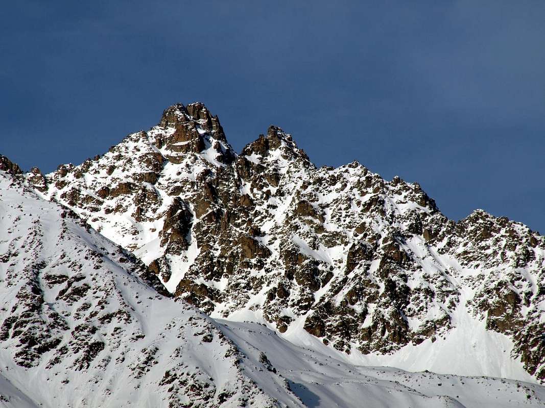
(1316 m), ai piedi della Catena del Mont Morion e sovrastato dalla tetra e quasi orrida Tour d'Oyace (1474 m). L'ultima parte di questa valle isolata e selvaggia si indirizza verso il Comune di Bionaz con la mastodontica omonima Diga, conosciuta anche con il nome di Places de Moulin. Da Oyace la Strada Regionale raggiunge i Villaggi di Serignan, Close, Place, Balme (1515 m), il Lago Lexert (1552 m) con la sua piccola "Area Naturalistica", Dzovenno (1564/77 m), Perquis e Bionaz (1622 m); da qui raggiunge Ferrère, Chamin, Léchère (1812 m) per terminare a Place Moulin o Place des Moulins (1980 m) al fronte Occidentale della Diga. Certamente questa scelta andrà a discapito di una visita più approfondita, osservando il tutto "en passant", ma soprattutto rinunciando a qualche breve e simpatica passeggiatina a piedi nei dintorni, come ad esempio nel 1934, sulle tracce dell'Abbé Henry e della Principessa Maria José con la sua Dama di Compagnia o "Chaperone" alla Cappella di Les Thoules Dessus fumando lui sigaro e lor sigarette fino alla tarda notte, dopo essere passati da Thoules Dessous, Grand Chemin, Lavod, Semon e Les Ansermins.
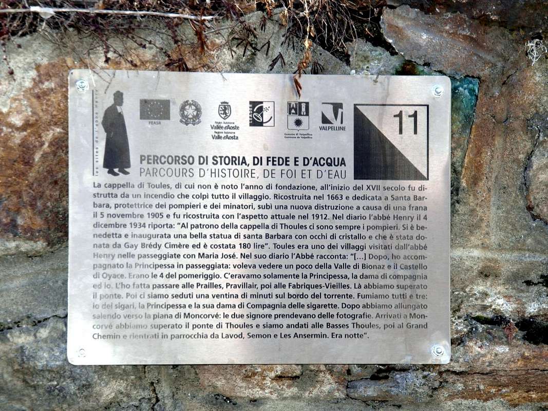
L'Abate nel Diario: "Al patrono della Cappella di Thoules ci sono sempre i pompieri ...". Rispondiam noi, 82 anni appresso: "Per forza, con tutti questi fumatori ...
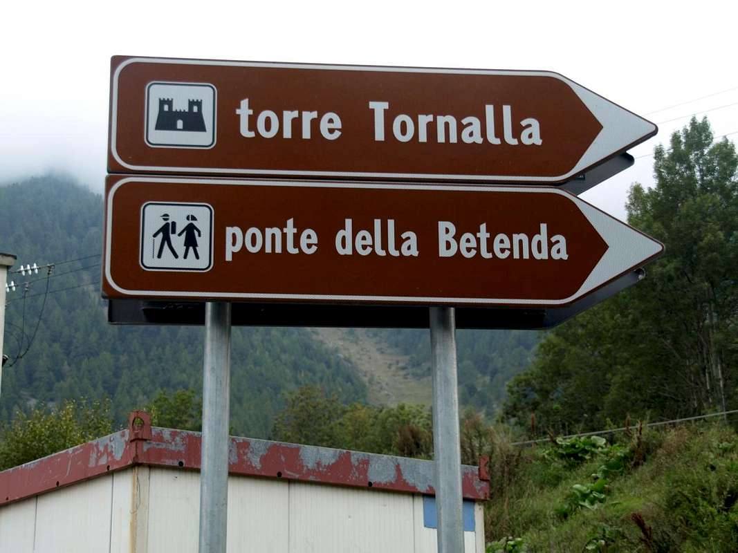


A small Trip to the Tour de la Tornalla the XII° Century


From small Villages Voisinal, Grenier, and Crétaz Serignan you can reach with a short walk this Tower "holed up" on the above-wooded rocky promontory.

A first trail n° 3 starts by Grenier-Vernoce Fraction (1257m), addressed first to the East, then Northeast and across the Bois "Les Cretes" reaches the Tornalla's Tower on its West side. The second, also well marked with signs in brown, always starts as n° 3 by the Village of Serignan-Chez les Bredy 
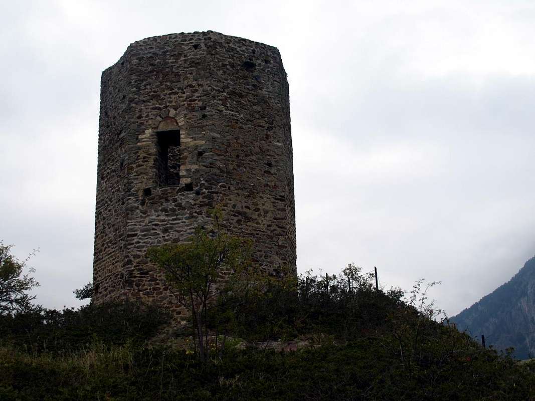
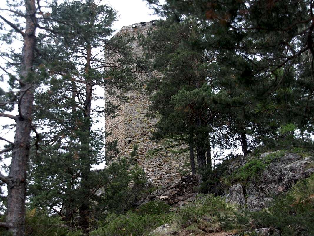
(1385m), soon after the Church of St. Michel and Crétaz Fraction, and begins the ascent to the East for then fall back strongly in the South. At the junction with the trail, down towards the underlying Betenda Bridge above the Buthier de Valpelline, turn sharply to the right (West) and drive past some small basins reaching a fence in a protective timber. A final more steep section and exposed to the South, by means of some steps on the rocky plates, leads to the Tour de la Tornalla, which is reached on its Eastern side (T/F; 0h'30). Currently at the start and at the "Bouc Plan" is under construction a direct variant that runs along the Northern side of the interior of the forest of "Plan Bouc". In any case, be very careful when children are present, since the grassy-rocky promontory summit, with some wooden benches on the side West, is very scenic but also very exposed on all sides, especially to the South and West.


Una piccola Gita alla Tour de la Tornalla del XII° Secolo


Da Voisinal, Grenier, Crétaz e Serignan si può raggiungere con breve camminata questa Tour "asserragliata" sul soprastante promontorio boschivo-roccioso.

Un primo sentiero n° 3 parte da Grenier-Vernoce (1257 m), rivolto dapprima ad Est e poi Nordest ed attraverso il Bois "les Cretes" raggiunge la Tour sul suo lato Occidentale.
Il secondo, anche esso ben segnalato con cartelli in marron, parte sempre come n° 3 dal Villaggio di Serignan-Chez les Bredy (1385 m), subito dopo la Chiesa di St. Michel e Crétaz, e inizia la salita verso Est per poi ripiegare decisamente a Mezzogiorno. Al bivio con il sentiero per il Ponte della Betenda svoltare decisamente a destra (Ovest) ed oltrepassate alcune piccole conche raggiungere una staccionata in legno protettiva. Un ultimo tratto più ripido ed esposto a Sud conduce, per mezzo di alcuni gradinamenti sulle placche rocciose, alla Tour de la Tornalla, che si raggiunge sul suo lato Orientale (T/F; 0h'30). Attualmente nella parte iniziale e presso il "Plan Bouc" é in fase di costruzione una variante diretta percorrente il lato Settentrionale all'interno della Foresta del "Plan Bouc". In ogni caso prestare molta attenzione in presenza di bambini, poiché il promontorio erboso-roccioso sommitale, con alcune panche in legno sul fianco Ovest, risulta molto panoramico ma anche alquanto esposto su ogni lato, soprattutto a Sud e ad Occidente.


Comments

No comments posted yet.


Children

Children

Children refers to the set of objects that logically fall under a given object. For example, the Aconcagua mountain page is a child of the 'Aconcagua Group' and the 'Seven Summits.' The Aconcagua mountain itself has many routes, photos, and trip reports as children.