
|
|
Mountain/Rock |
|---|---|
|
|
42.8386°S / 72.6509°W |
|
|
Download GPX » View Route on Map |
|
|
Hiking, Scrambling |
|
|
Summer |
|
|
3681 ft / 1122 m |
|
|
Overview
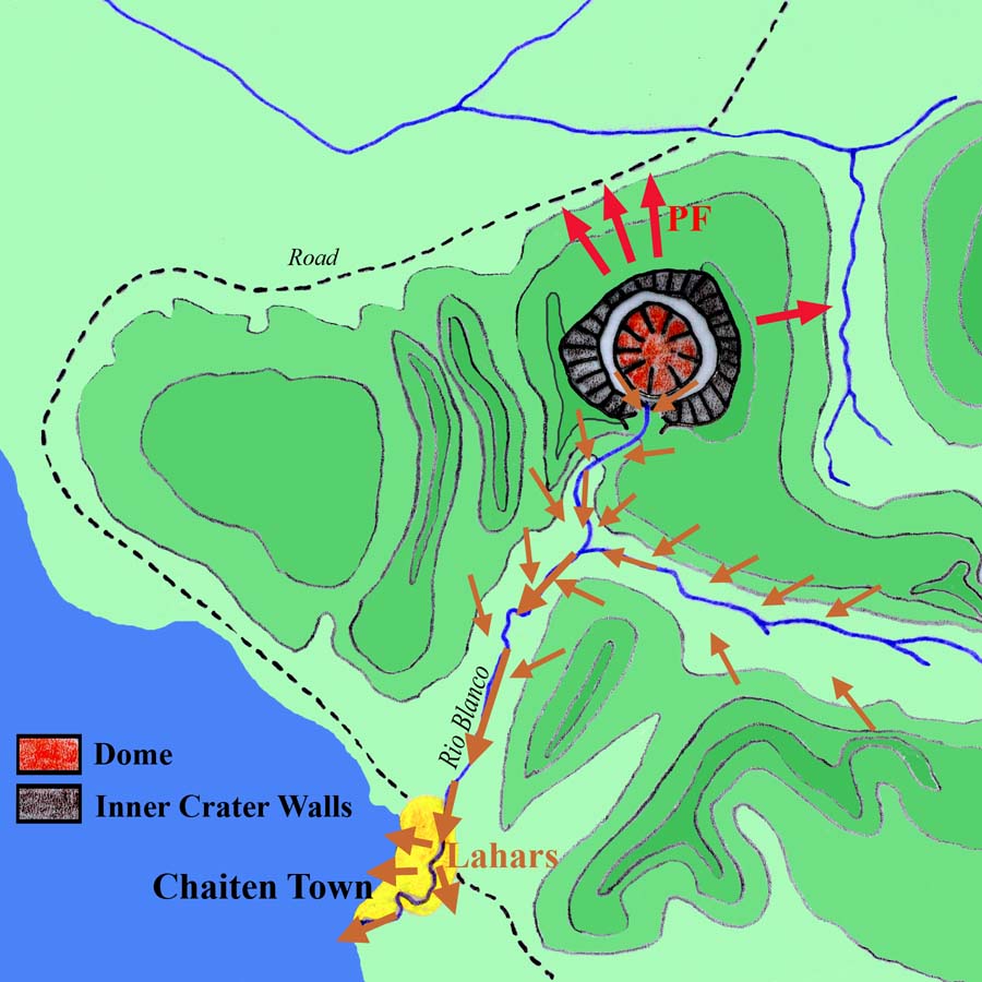
Volcán Chaitén in southern Chile is formed of an active lava dome growing within a 4 km by 2.5 km crater that was formed ~9000 years ago. The current eruption began in May 2008 after a repose of perhaps 5000 years when the previous dome formed. The current sequence began with a large explosive phase and led to the near total inundation of the nearby Chaitén town with mud in addition to blanketing a much larger area, including parts of Argentina with ash. Rhyolitic dome growth followed, something not really seen since the Katmai eruption in 1912. This activity is still ongoing on the west end of the complex which comprises several centres of effusion within the main caldera. Activity is manifest as a slow increase in elevation, with rockfalls occurring on flanks and a gas plume emanating from the summit. Some modelling of the minerals in erupted rocks has suggested that the magma involved rose very quickly from a 5 km deep magma chamber with very little seismological warning. There was so much surprise about the eruption that it was first thought to have emanated from the nearby Michinmauida / Minchinmavida, last active in 1835. Prior to the 2008 eruption Chaitén had a small dome and was covered in forest, see this photo from 2003. This page describes accessing the crater floor by the base of the dome only, with a theoretical treatment of carrying on up it for those of you that are crazy. The pre-eruption high point was on the SE side of the crater rim, just to the east of the main breach. Whether that's still the case I'm not sure.
Getting There
From the north: Take one of the daily Navimag ferries from Puerto Montt to Chaitén town, though it's possible from Castro or Quellon also which are on the island of Chiloe though those services are less frequent. The Puerto Montt ferry gets booked up as it's pretty much the only way north/south through the country given the road damage due to the eruption so plan ahead, particularly if you have your own vehicle. The ferry company website appears erratic so see what you can do by phone or it may have to be in person at their office in Puerto Montt. Ferry takes about 8-10 hours or maybe some hours more depending on tides or other random things.  Michinmauida and Chaitén Michinmauida and Chaitén |
 Ferry terminal Ferry terminal |
 Chaitén town Chaitén town |
From the south: Access from the south is via road with the nearest border crossing with Argentina is at Esquel (Arg.) / Futaleufu (Chile) else the next main crossing south is Los Antiguos (Arg.) / Chile Chico (Chile). There are daily public transport vehicles plying this route that may or may not break down on you.
Once you get to Chaitén town: At the time of my visit in January / February 2010 there was essentially a restaurant, a shop or two and a couple of places to stay but little else functioning. Local source of assistance may be a Nicolas who operates a travel agency called Chaitur out of the 'bus station' in town, kinda pricey if you need rides but he's been up the volcano a few times with some USGS folks over the years so knows his stuff.
|
|
 Chaitén area map Chaitén area map |
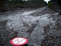
From Chaitén town to the volcano: Ideally you would head 6 miles north-west to Santa Barbara where you can also stay and then another 7 - 8 miles east along the road to where it gets cut by a river and assorted fallen trees. There's an airport en-route so watch out for barriers and follow procedures. If you're on your own vehicle note that water levels can fluctuate dramatically so don't park at the bottom of the dip that you'll come to. From there head along what's left of the road, skirting rivers, climbing trees and whatever else comes in your way for about 1200 m / 15 minutes till you get to the source of the water coming in from your right. Here is where there is an obvious "damage zone" to your right also (i.e. some standing but dead trees rather than green ones). You should be able to see the volcano through these dead trees. If you have come to a bridge then you've gone a few hundred metres too far.
Alternative first ascent option: Various parties have looked at climbing into the crater from the Chaitén side. There is a river drainage, see external map here and external photos here and here (from 2003), you can follow for numerous hours and theoretically work your way up there but to my knowledge no-one has successfully managed to do this. Plus the risk factor from getting hit in the face by rocks is higher too.
 Park before here Park before here |
 End of the road End of the road |
Route on the mountain
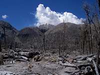
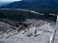
Stage 1 - Through the trees: After following the directions above, head straight through the trees keeping the volcano in front of you. You will reach the tree line (i.e. where instead of standing up and dead they're dead and all over the floor) after about 5 minutes from which point the view is open and you can see the top of the and the potential routes ahead. You can freestyle it quite easily but GPS coordinates of the route that we took and a more detailed description is given here which takes maybe 3.5 hours from where you can no longer drive to the crater rim and from there to the crater floor.Stage 2 - Flat section: From the tree line you can ascend to the rim by choosing either to follow the left hand bank of the river that descends from the volcano or the right hand side. Choosing the left hand side as will be described here makes it much easier to proceed down into the crater while the right hand option gets you higher up on the rim. Traversing between the two points while possible is particularly steep and hazardous and only for the confident. Choose which side you will take early on as after a few hundred metres the river is too deeply incised to cross. As you proceed along the left hand bank you will have to navigate around and over many large splintered fallen trees. Head in the direction of the light coloured scar / drainage that comes down the flank of the volcano.
 At the tree line At the tree line |
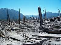 Pyroclastic blasted trees Pyroclastic blasted trees |
 None of this None of this |
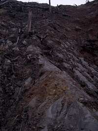
Stage 3 - Slope climb: Once at the base of the scar head straight upwards, or by some other means you see fit. The idea here is to save yourself the tedium of working your way through the fallen trees waiting for you to your left. Once the slope becomes too steep and slippery to climb, cut left into those trees then head straight upward till you get a view of the dome. Now head up and right towards the crest of the ridge taking the path of least resistance as there is faint but convenient one.
 Top of scar Top of scar |
 Between scar and ridge Between scar and ridge |
 Almost to ridge crest Almost to ridge crest |
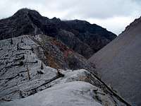
Stage 4 - Ridge crest: The going gets somewhat easier here as the ground is a little less steep than the last section. At first you have to contend with many fallen trees as usual but as you continue the ash thickens up and the trees disappear underfoot. Proceed along the ridge crest till you get to the crater rim noting that the ash here is very hard parked and can be slippery to walk along so take care. The same goes for subsequent travel round the crater rim as described below.
 Beginning of ridge crest Beginning of ridge crest |
 Ending of ridge crest Ending of ridge crest |
 View back down ridge crest View back down ridge crest |
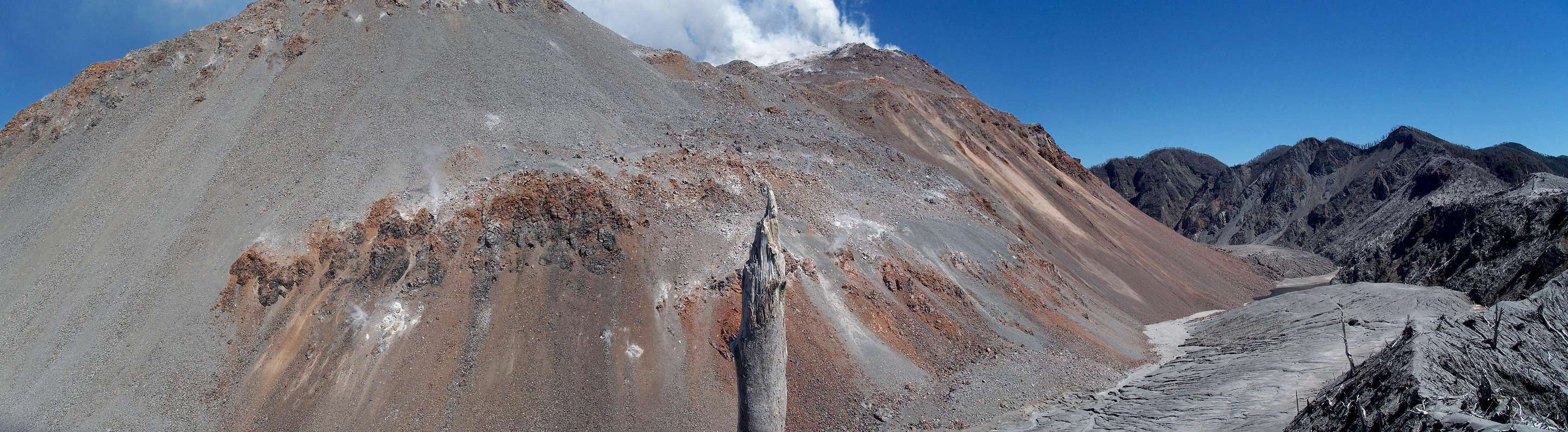
Stage 5 - Crater rim: Take in the views, you've earned it.
 View of crater rim to the E View of crater rim to the E |
 View of dome from crater rim View of dome from crater rim |
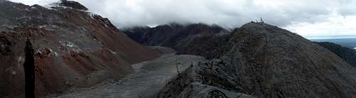 Chaitén complex overview looking WSW Chaitén complex overview looking WSW |
Stage 6 - Descent into the crater: When you arrive at the crater rim head to your right and descend to the lowest point on the rim. Here, while daunting, is a way down into the crater if you like trusting your life to mud and broken bits of wood sticking out of it. The top 10 m are the steepest and trickiest, past that you'll be fine. Note the weather in the crater itself can be very different from the weather up on the rim. The wind can be very strong and blow things away if you're not careful. While down here you might want to wander around as it's much easier to traverse around the dome on the flat than going round the rim, the complete circumnavigation of which would require technical climbing gear as there are many deep ravines cutting across.
 Crater route overview Crater route overview |
 Crater route detail Crater route detail |
 View from crater floor View from crater floor |
Stage 7? - Theoretical ascent up the dome: Continuing from the crater floor up on to the dome from the same side would not present any particular technical challenges as the going is just a several hundred metre climb over unstable bouldery scree. The issue would be getting to the highest point which appears to be the active vent in the west which is steaming away in the below photo. You would be contending with rocks falling on you, extreme heat, possible explosions and a severe lack of oxygen.
 |
 |
GPS coordinates for route
All of these are based on the WGS 84 datum. Note that most satellite maps continue to use pre-eruption imagery and topography and so differ from the current situation on the ground. As well as a lot of the trees being gone, the dome is now much bigger and the moat shallower due to infilling. What looks on maps like a 100 m or more descent from the north rim of the crater into the moat is now half that. That being said because of the unusual topography in the region the accuracy of some of the GPS points might not be perfect (multi-pathing signals etc.). Am experimenting with the map and GPX file at the moment so it's subject to change.
|
Red Tape / Weather / Activity
Red tape: Approaching Chaitén volcano from the north technically puts you in the territory of Parque Pumalin. You should get permission to climb from the administration, perhaps be email/phone or you can try in person at the office at the park entrance just north east of Santa Barbara once you get past the airstrip though I'm not sure if it's actually open. However the head ranger usually makes daily trips up and down the road running from Santa Barabara east past the volcano also.Weather: Given the largely non technical nature of the route you could probably go any time of year but would have most fun during the southern hemisphere's summer months which are typically very clear, though have in 2010 been anything but. Rain makes climbing over giant slippy trees a much trickier business. While this sounds farcical think how much of a problem you'll have getting out of there with a broken ankle or a impaled leg. As mentioned earlier, wind conditions in the crater can be much stronger than evident while up on the crater rim.
Activity levels: For most current conditions check the GVP page as well as SERNAGEOMIN´s webcam shots towards the bottom here. In terms of risk, biggest danger is falling off a tree that you're climbing on or falling down the crater wall. There may be a risk of rocks avalanching on you from the dome if you're unlucky or too close to the action. Also a chance of another cataclysmic explosion or being hit by lightning but it's pretty small right now.

Camping / Accomodation
Officially you can't camp in Parque Pumalin to my knowledge given the volcanic activity but you may be able to negotiate something. That being said, you can camp down by the beach in Santa Barbara, or stay in one of the cabanas there or at a pretty nice and extensive place called 'Resedencial El Patito' that is essentially a hotel that will feed you plenty. You can also stay in Chaitén itself where there a few options, including 'Hospedaje Don Carlos' at Almirante Riveros 53 (Ph. 91283328) though I can't vouch for anything in particular. Again, you may want to contact Nicolas who operates a travel agency called Chaitur in town to get updated info. Santa Barbara
External Links
Global Volcanism Program Detailed eruption history
Chaitén page by R. Roscoe who visited in December 2009.
Lots of good photos inc. aerials.
Guided trip company Don't know anything about them myself though.
Nrsmith1213 - Jan 3, 2016 12:19 pm - Hasn't voted
Chaiten UpdateI am currently in Chaiten. The town seems to have certainly progressed since the initial summary. There are a few more hostels, restaurants, and businesses in general. Just a block down from the bust station, on Calle(street) Bernardo O'Higgens, there is a green bus that serves coffee and food. The folks who own the food bus, Tommy and Lotta, also own the tourist agency across the street, Natour. They would be happy to give you any tourist info you need and also lead hikes to the Volcano as well as kayak tours to see sea lions and Chilean Dolphins. If you hang out in the bus long enough you'll be sure to meet some locals who can probably give you info on how to access the many areas around town where you can hike, climb, or trailblaze.