
-
 21923 Hits
-
 93.65% Score
-
 44 Votes
|
|
Mountain/Rock |
|---|---|
|
|
44.32370°N / 109.6065°W |
|
|
Park |
|
|
Hiking, Scrambling |
|
|
Summer, Fall |
|
|
12165 ft / 3708 m |
|
|
Overview
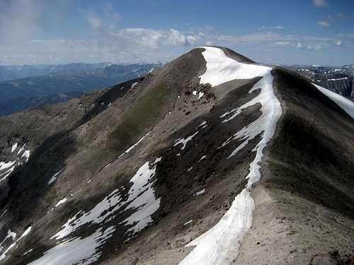 Nearing the summit of Wapiti Ridge
For mountaineers who like solitude, adventure, and remote peaks that are rarely (if ever) climbed, Wyoming's Absaroka Range is heaven. The range is split into three subranges (North, Southeast, and Southwest), and each has its own character and feel. The peaks in the Southwest Absarokas are some of the most remote peaks in the continental United States, some of which are 20-25 miles from the nearest roads. This can be a dangerous place to climb due to the rotten and loose rock, and the large populations of predators like grizzly bears, mountain lions, and wolves should not be taken lightly.
Believe it or not, the highest peak in the Southwest Absarokas does not have an official name; Wapiti Ridge is a 30-mile long chain of mountains that runs parallel to the South Fork of the Shoshone River, and the highest point in the range is located near its middle at 12,165 feet. Ptarmigan and Citadel Mountains are the only named peaks along the eastern part of the ridge, but both are about 200 feet lower. For the purposes of this page, I am referring to this peak as Wapiti Ridge. The word "Wapiti" is derived from the Shawnee Indian word for elk, an animal that is found in abundance in this area.
Reaching this spectacular summit is not an easy undertaking, and while it can be done in a day, most people will require two days to make the trip. The route from the Bobcat-Houlihan trail head to the top is only around nine miles, but the 6100 feet of elevation gain, 4000 of which happens over the last three miles, is a killer! From the top, you will have amazing centralized views of most the three Absaroka ranges, as well as a distant look at the Tetons.
In addition to being the range highpoint, Wapiti Ridge ranks 16th on the Wyoming prominence list with 2,505 feet of prominence.
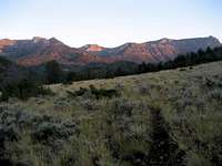
 Absaroka Beauty
Getting There and Climbing Information
 Bobcat-Houlihan route on Wapiti Ridge
Starting from Cody, Wyoming, turn south 0.4 miles west of the traffic light in front of Wal-Mart onto the South Fork Road (291). Travel this scenic road for about 27 miles and turn right on Road 6Eh; there is a sign directing you to the Bobcat-Houlihan trail head, which lies along the same road that goes to the TE Ranch. This roads descends to the river and crosses on a bridge at about 2.2 miles. Turn left immediately after crossing the bridge and drive another half mile to reach the trail head, which is on your right.
 Bobcat-Houlihan trail head
 Bobcat Creek crossing
Hike for half a mile past the parking area to a gate which enters the Shoshone National Forest and continue for another two miles along the base of the hills until you reach Bobcat Creek. The trail then heads into the drainage, staying on the right side of the creek as it eventually switchbacks onto a small plateau, at which point you will get your first good look at the mountain. The summit is not visible from here, but it is located on the ridge out of sight to the left of the large rock pyramid near the head of the Bobcat drainage.
 Early morning on the trail
 Looking back down
From here the trail drops to the first of three crossings of Bobcat Creek. The first one is the hardest, and it is fairly rocky and moves fast; my climbing partner (Tim Worth) and I threw a couple of downed logs across on the hike out, but on the way up we were able to find a spot a little ways downstream that was tricky to jump, but doable. The second crossing happens about another 100 yards down the trail and was a long jump from a rock, while the third was easy. The trail then begins to get steep as it ascends a ridge on the right side of the creek, gaining 2700 vertical feet in the next 2.7 miles before it disappears in a meadow just below the rock pyramid, which now looms very close.
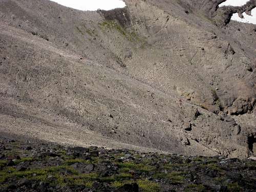
 Big wall at the base of Wapiti Ridge
This would make a great spot to set up camp for anyone taking multiple days to make the climb. From here you have a couple of options, and as is often the case in the mountains, one is shorter and harder while the other is longer and easier. The short route crosses a boulder field to the west underneath the rock prow and continues to follow the right side of Bobcat Creek to its head beneath the summit. Ascend steep scree slopes to the right and find a way onto the ridge before heading left to the summit; I did not go this way so I can't testify as to the route-finding, but after viewing it from the ridge above, there may be some pretty loose scrambling sections and a couple of Class 3 moves to reach the ridge. Reaching the ridge from the meadow by this route is about 1.7 miles with 2700 feet of gain, so it is steep!
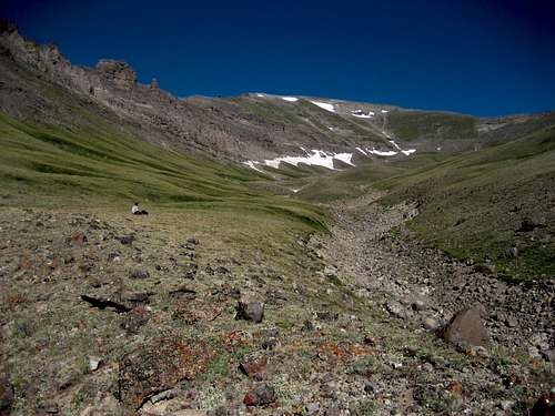 Contemplating the route up to the ridge
The other way up is to head to the right through the valley below the pyramid and make for the obvious notch on the right of the unnamed creek that comes down from above. Scramble up the steep slope to reach a beautiful valley to the southwest of point 11698. From here, ascend the gentle grassy slopes to the saddle on the ridge, which overlooks Hardpan Lake and Ptarmigan Mountain. This way only gains 1800 feet in a mile and a half to the saddle, which sits at 11,500 feet. Head left along the ridge onto a high plateau at over 12,000 feet before dropping through a little rock gully and descending 200 feet to another saddle below the actual summit. The extra mile that this route adds is well worth it in my opinion!
 Easy gully on the saddle below the summit
 Wapiti Ridge summit register
The summit views go seem to go on forever, with a sea of mountains on all sides. The Washakie Wilderness is a truly large place, and this is one of the best summits I've ever visited for appreciating the vastness of the magnificent forested drainages and rugged mountains that make up this part of the Southwest Absarokas. Looking back down the Bobcat Creek drainage to the South Fork Valley over 6,000 feet below in the distance is also a daunting sight, as you have a long ways to go to get back to the car, and your knees will probably hate you for it!
A round trip to summit of Wapiti Ridge is around 18-19 miles, depending on the route taken near the top, and there is 6100 feet of elevation gain from the trail head; nothing on the route is harder than Class 2.
Summit Views
 West
West North
North Southwest to Younts Peak
Red Tape and Camping
 Grizzly tracks on Wapiti Ridge
There are no fees to use the Bobcat-Houlihan trail head. Camping is allowed within a fenced area at the trail head and in the Shoshone National Forest. Be sure to research camping regulations specific to this area on the SNF website.
As noted in Tom Turiano's book Select Peaks of Greater Yellowstone, this is not a place to be during hunting season; if you must go, wear bright colors and watch out for the hunters. He also says that this is a very popular area with illegal outfitters, I'm guessing in part due to the area's remote nature.
If you are climbing Wapiti Ridge in a day, start your hike very early to avoid thunderstorms, which often form in this area as early as noon. Getting off the ridge and the exposed areas above treeline is not done quickly, so keep an eye on the sky.
Tim W. and I saw four grizzlies on the ridge just east of the summit, so keep your eyes open for wildlife as well!
 Grizzlies below the summit (red circles)
External Links
Army Cutworm Moths and GrizzliesShoshone National Forest
Wikipedia entry for the Shoshone National Forest
South Fork Ice Climbing
 Breccia Cliffs