
-
 8263 Hits
-
 76.66% Score
-
 7 Votes
|
|
Route |
|---|---|
|
|
44.03010°N / 114.635°W |
|
|
Hiking, Scrambling |
|
|
Spring, Summer, Fall |
|
|
Most of a day |
|
|
Class 3 |
|
|
Washington Basin 6 Peaks Traverse
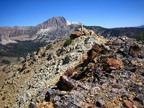
This popular and logical traverse is one of the best link-ups of multiple peaks in the state of Idaho. Six peaks can be scaled in a day with 5 of the peaks being above 10,000 feet, several sub peaks to cross, and several visits to terrain below 10,000. Most all of this traverse is Class 2 with just one section of Class 3 and the possibility of more optional Class 3 terrain. One can easily bail out from the ridge at many spots with minimal effort if need be, and although water is usually non existent, the traverse can be done quickly enough where you can carry what you need from below. Furthermore, trails lead to the start and finish of the traverse so there's minimal valley bush-whacking.
The views from the summits are impressive and include many of the peaks in the range and many beautiful lakes (Phyllis Lake, Heart Lake, Champion Lakes, Washington Lake, and Washington Basin Lake). One aspect to this area that stands out is the impact and footprint of motorized vehicles at some very high elevations and trails. Not only will you find motorcycle tracks at 10,000 feet or more, but the legacy of mining is found in the form of old cabins, machinery, and steep roads.
From the 4th of July Trailhead: 18.1 miles and 7074 feet gain (total)

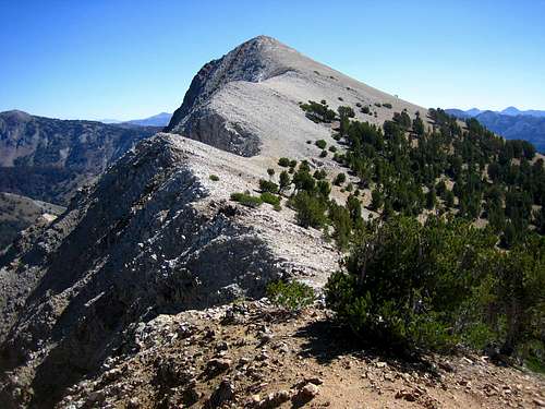
4th of July Peak (10,713) -Northeast Ridge (Class 2)
Leave the trail at the prominent pass northwest of Washington Lake and ascend the northeast flank of the peak. Once on the ridge, there's usually a climbers path through the dirt and the route climbs onto rocks and talus as the route turns south and becomes the north ridge of the peak. Easily scramble past a small notch on the ridge to the true summit where you'll have great views of Ebony and Ivory.

Ivory Peak (10,408) -North Northeast Ridge (Class 3)
The North Northeast Ridge of Ivory is nearly sustained Class 3 terrain amongst a mostly Class 2 ridges traverse.
After descending the steep and rugged south slopes of 4th of July Peak (note that there's several vertical drop offs and fins of rock here), find the broad pass between the peaks. Ascend the beginning of the NNE ridge on the south side of the ridge near the pass, then follow the ridge proper past a few steep rock towers that make this section of the traverse sustained Class 3. The nature of the rock changes to a brittle, blocky, steep white ridge. Either climb over the direct ridge (Class 3+), or visit the north side ledges (Class 3) to obtain the summit.

Ebony Peak (10,514) -East Ridge (Class 2)
Descend steeply to the west, but easily, to the small saddle between the peaks and ascend the dark open slopes of Ebony. Notice the greenish blue lakes below on the north side (Phyllis and unnamed 9576) and the mining remnants and roads south in the upper Washington Basin. The summit of Ebony is broad and long and it appears the easternmost portion of rocks is the high point along this long dark ridge.

Washington Peak (10,519) -NorthEast Ridge (Class 2)
First ascend over Point 10,500, then over the open, steep slopes toward the summit of Washington Peak where you may find a climbers or goat trail. At the time of writing, this was the only peak in the area to have a summit log (white PVC tube). The views are exceptional of the Champion Lakes basin and even though the peak is only marginally taller than it's neighbors, this peak seems to tower above the terrain. From the summit south, there's usually a good climbers path leading toward Point 10,322.
Croesus Peak (10,322 / 10,288) -West Ridge (Class 2)
First descend down steeply through a rocky gully from Point 10180 to the broad saddle where you'll most likely see a motorcycle / hikers path. Ascend steeply the west ridge avoiding the small sub alpine fir on the north side of the ridge. Visit the true high point of the peak, then ridge traverse over to the more prominent 10,288 where the map denotes this peak and there's often a large summit cairn and marker. Goats can be found anywhere along this traverse, but they were viewed in the area in late August of 2007. Descend steeply down the very loose east slopes toward the Croesus-Bible Back saddle.

Bible Back Mountain (9,928) -West Ridge (Class 2)
From the saddle west of the summit, the rugged and steep north slopes of Croesus are highly impressive. There's also an old mining cabin found here and many open mining pits all over the east and west slopes of Bible Back. Use caution if quickly descending. Climb the short and steep west slope to the summit where there's often a large stick and cairn. Descend the open northeast slopes of the peak toward the old mining trail. Briefly follow that south, then leave the trail and continue to descend to Washington Creek and the trail confluence with Washington Lake Creek where you can just follow the trail back north to Washington Lake and eventually to the 4th of July Trailhead.
