
-
 8545 Hits
-
 75.81% Score
-
 6 Votes
|
|
Mountain/Rock |
|---|---|
|
|
46.72350°N / 10.48830°E |
|
|
Hiking |
|
|
Summer, Fall |
|
|
8366 ft / 2550 m |
|
|
Overview
 Watles seen across Malser Heide Watles seen across Malser Heide |
Monte Vatles (German: Watles) is one of the fine lookout peaks along the northern part of the Vinschgau / Val Venosta Valley. It compares to neighbouring Seebödenspitze (Cima Pian del Lago) and Köpfleplatte on the other (eastern) side of the valley. Its location - almost directly to the west of where the valley of the Etsch / Adige bends northwards - ensures great views along the ridges of the highest groups of the eastern Alps. To the south there is the Ortler / Cevedale Group, to the northeast are the Ötztal Alps, to the west massive Sesvenna looms while to the southwest you can get glimpses of of the Bernina Group.
 |  |  |
The mountain itself is not so much of a beauty. It is a grassy knob which easily can be summitted. There even is a cablecar which can take you up to Plantapatsch Hut at 2056m from where the remainder of the ascent is just like a stroll. There are three easy ascent routes towards the summit, the most popular of which touches the beautiful Pfaffensee, a lake located directly above the Vinschgau / Val Venosta Valley. Thus be prepared to meet a lot of people on Watles - it is a popular spot. Still Vinschgau / Val Venosta is a rather lonely hiking region - so a crowdy day on Watles means meeting some twenty people on the top.
 |  |  |
I visited the region in September 2000 and summited Watles during the end of my stay. Don't ask me why I didn't take any more pictures of the area - I guess it was so breathtaking I just forgot. I would definitely recommend this time of the year for a stay in the region - all the cablecars are still running but the trails are very lonesome. Never met more than 5 people a day except for the regional hotspots - Watles is one of them.
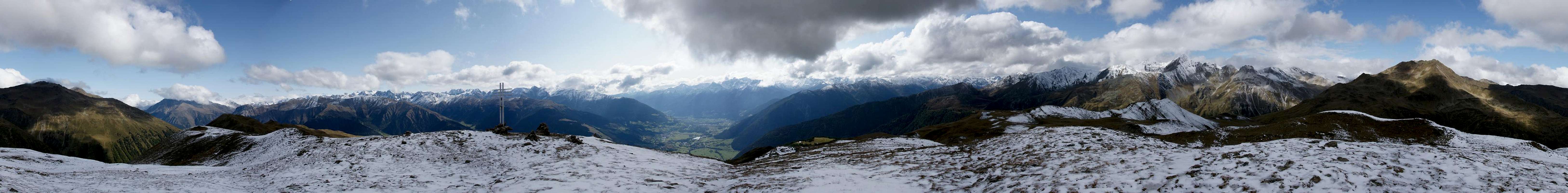
360° Summit Panorama
  |
Getting There
 Piz Nair Ridge seen from Spitzige Lun, Watles to the left
From Italy
Take the Brenner motorway (A22) which you leave at Bozen (Bolzano) south. Take S38 (Vinschgauer Staatsstrasse) northwards towards Meran (Merano). The road follows the Etsch (Adige) Valley into Vinschgau (Val Venosta). Follow the road westwards until you reach Tschengls (Sengles). (Here S38 goes on towards Europe’s highest pass, Stilfser Joch (Passo dello Stelvio)). Instead follow S40 northwards until you reach Burgeis (Burgusio).
From Austria
Take Inntalautobahn (Motorway A12) westward from Innsbruck to Landeck. At Landeck turn onto road 180 which winds its way upwards the upper Inn valley towards Nauders. Between Nauders and Reschen (Résia) you cross the border and are directly on the shore of Reschensee (Lago di Résia). Go onwards until you reach Burgeis (Burgusio).
From Switzerland
Take motorway A3 from Zürich or E43 from Bregenz southwards in the direction of Chur. Shortly after the motorways meet turn off onto road 28, direction Davos. Behind Davos at Susch the road splits (27 / 28). You can take either roads - the southern one (28) leads you over Ofenpass (Passo dal Fuorn) into Vinschgau (there take SS40 northwards to Burgeis), the northern one (27) goes to the Swiss Austrian border near Pfunds where you turn southwards again on 180 and head for Nauders, Reschen and Burgeis.
Red Tape
 Sesvenna Group seen from Watles
No red tape, no permits required no parking fees. Like Seebödenspitze this is a ski region so the slopes are pretty eroded anyway.
When To Climb
Watles can be climbed all year round. In winter you can do ski tours towards Schwarzer Kopf, Seebödenspitze, Elferspitze and Zehnerspitze.Accommodation
For accommodation you can contact the Vinschgau Tourism office atTourism association Vinschgau
Kapuzinerstraße, 10
I - 39028 Schlanders
Southtyrol - Italy
Tel. +39 0473 62 04 80
Fax +39 0473 62 04 81
E-Mail : vinschgau@suedtirol.com
Web page: www.vinschgau.org
Another worthwhile web page is www.suedtirolerland.it.
Weather Conditions
For weather conditions in South Tyrol look at the page of Meteo Alpin. For the english text you have to scroll down the right frame.Other sites with weather and webcam-links are
- www.vinschgau.org
- www.suedtirolerland.it
Maps 'n' Books
I used the following Map and Book, both by Kompass Verlag (and in German - the map has an Italian section, though).Map
Vinschgau / Val Venosta
Kompass Map WK 52
Kompass Verlag
ISBN: 3-85491-058-4
Book
Vinschgau / Ortlergruppe
Kompass Hiking Guidebook 950
Kompass Verlag
ISBN: 3-85491-404-0