
-
 15549 Hits
-
 85.35% Score
-
 20 Votes
|
|
Route |
|---|---|
|
|
48.69100°N / 113.636°W |
|
|
Mountaineering |
|
|
Summer, Fall |
|
|
Most of a day |
|
|
Class 3 |
|
|
The West Face Route:
Layout designed for best viewing on a "1024 x 768" screen.
 |
|---|
The photo on the left of Going-to-the-Sun was taken from the Piegan Pass Trail. The West Face Route begins where the scree field meets the cliffs slightly to the right of the lowest point on the GTTS ridge.
The West Face Diagonal Chute Variation's gully reaches the summit ridge on the far left of this photo directly above the top of the pine tree on the left.
The following information is from the Glacier National Park website:
Going-to-the-Sun Mountain was named by James Willard Schultz for what he claimed was an old Indian legend, in which Napi, the Old Man, came down from his home in the sun to help his people, the Blackfeet, out of their difficulties. When his work was done, he returned to his home in the sun, up the slopes of this mountain. This legend however, was probably invented by the white men, and may have originated within Schultz, who was not above flowering up his stories to make them have more reader appeal.
The West Face Route Overview:
To visit Glacier National Park is to enter a place where Heaven touches Earth affording brief glimpses into the Wonders of Creation.
The West Face Route of Going-to-the-Sun is rated Glacier Park Class 3 with two class 4 cliffs just above the scree on the west slope.
An up-to-date guidebook for this route can be found in Climb Glacier National Park, Routes for Beginning and Intermediate Climbers; Volume 1: Logan Pass, The Garden Wall, and Siyeh Bend. Purchase it when you arrive in northwestern Montana or purchase it on-line at Climb Glacier National Park.
This route is also outlined on pages 248 – 251 in A Climber's Guide to Glacier National Park by J. Gordon Edwards. Total distance to the summit of Going-to-the-Sun is 4 miles and total elevation gained is 3,700 feet.
Edwards noted that the summit of Going-to-the-Sun is NOT a place to be in threatening weather. Check the local weather forecast prior to climbing Going-to-the-Sun or any peaks in Glacier National Park. Check out Glacier National Park's What's New Page with weather, road conditions and the usual happenings at Glacier National Park.
 |  |  |
|---|
Click on the Linked Text to View More Photos of the Route
Views from the top of Going-to-the-Sun place a unique perspective on Logan Pass as well as the St. Mary’s Valley. The nearest neighbor Matahpi at 9,365 feet in elevation is overshadowed by 10,014 foot Mount Siyeh to the north. The views to the Garden Wall and the southeast face of Mount Gould could possibly be described as Glacier Park at it best. Piegan Glacier can clearly be seen on the face of Piegan Mountain and the views to the west into Logan Pass are truly spectacular.
The West Face Route Approach:
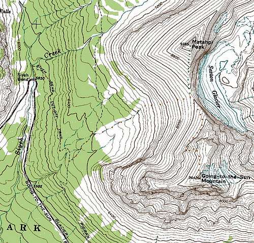 West Face Route Topo
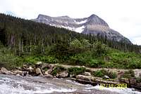 GTTS from Siyeh Creek near Siyeh Bend the trail on the streambank leads to the junction with the Piegan Pass Trail
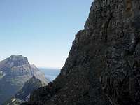 GTTS viewed from Reynolds Goat Trail.
After walking 1 mile from the Siyeh Bend to the junction with the Piegan Pass Trail turn left (north). Continue approximately another ½ to ¾ mile through the evergreen forest past two permanent streams into an open meadow from which views of the saddle between Going-to-the-Sun and Matahpi can be seen. An easy path is to follow a dry stream bed as it steps up the valley as it approaches the band of cliffs. It is possible to pick and choose a route through the diorite sill below the talus slopes to gain access to the saddle between Going-to-the-Sun and Matahpi. Mark the top of the diorite sill for identification on the descent. Edwards notes that easier routes through the cliffs are found to the left (north). After climbing through the diorite sill follow goat trails up the slope to the saddle between the two peaks. Upon reaching the take time to enjoy the views to the east. To see a different perspective of the saddle between Going-to-the-Sun and Matahpi click here .
The West Face Route Description
 |  |  |
|---|
Follow a goat trail slightly below the crest of the saddle through the scree fields below the cliffs of Going-to-the-Sun. This trail leads to the prominent gully on the West Face as described by Edwards. Continue south on the trail as it dips below the place where the cliffs reach the lowest in elevation. It is necessary to loose a little elevation at this point. Just past this lowest portion is where the “deep gully” is found. Watch your footing and be cautious not to loosen any rock on those climbing below. Carefully climb through two sets of class 4 cliffs to another scree field. Mark your area of descent well as the rim above the cliffs can easily look the same in a number of places. Once above the cliffs choose any route to the ridge or angle to the right (south) and head directly to the summit.
The summit block requires a small degree of route finding but is an uncomplicated scramble through class 3 rock. Once on the ridge is is a mere ridge walk to the summit cairn.
Returning Down The West Face Route:
 Descending to the cliffs
As with down-climbing on any off trail route be cautious of vegetation and loose or wet rocks that could cause a loss of balance or fall. This is especially true on this route.
 Matahpi Peak from GTTS approach
Retrace the route to the saddle between Going-to-the-Sun and Matahpi. An optional side trip is to summit Matahpi which is comprised of a class 2/3 scramble for 1,000 feet from the saddle between Going-to-the-Sun and Matahpi. If an ascent of Matahpi is not planned proceed down the scree fields to the diorite sill and return to the Piegan Pass Trail.
Essential Gear:
 Bob enjoying the view from GTTS, bring your lunch the view is awesome!
Hiking poles will aide in your ascent and descent while working through Glacier’s wonderful scree on the approach!
Gaitors are also helpful while descending to keep rocks out of shoes.
A GPS would help in locating the correct routes for descent.
A helmet would be useful will going through the cliffs.
Bring water as this is potentially a dry route after leaving the two permanent streams on the Piegan Pass Trail.
If an early season climb is made an ice axe and crampons may be needed to cross snowfields.
As with all hiking and climbing in Glacier National Park use caution and practice good manners with the wildlife. You are in bear country. Carry your bear deterrent spray, don’t hike alone and make some noise. For more information please go to the Park's website for Bear Information. The U.S. Forest Service also has helpful information on Grizzly Bear Management.
Guidebook and Links:
GUIDEBOOK: A Climber's Guide to Glacier National Park ; J. Gordon EdwardsGlacier National Park in Pictures
Glacier Mountaineering Society
Visit Montana
You do not have to register for day climbs in Glacier National Park but it is recommended. Backcountry travel regulations can be found at Backcountry Travel. There is also information from the Park Service on Mountain Climbing in Glacier.
Thanks to my friends who make everyday in Glacier some of the best days of my life and a HUGE thanks to our wives for trying to understand the addiction to Glacier National Park!
 The father and son team, my friends, SP members, montanarendonk and Vantana.
 FlatheadNative and "What About Bob?" on the descent from GTTS.