
-
 11338 Hits
-
 72.08% Score
-
 2 Votes
|
|
Route |
|---|---|
|
|
40.52270°N / 111.7434°W |
|
|
Ridge scramble |
|
|
Less than two hours |
|
|
Class 3-4 |
|
|
Overview
The summit of Bighorn Peak is probably reached most easily via the east ridge, as described in the East Ridge via Bells Canyon route. An alternative route to the summit is via the west ridge. This would most practically be done as a traverse from the summit of Lone Peak.The scrambling on the west ridge of Bighorn Peak is more difficult and exposed than the east ridge, but can generally be kept at class 3 with careful routefinding.
 |  |  |  |
Stats
Distances and elevations given here are measured using the summit of Lone Peak as the starting point for the traverse to Bighorn Peak.One-Way Hiking Distance: 0.75 miles
Elevation Loss: -703 ft.
Elevation Gain: 327 ft.
Lone Peak Elevation: 11,253 ft.
Lone/Bighorn Saddle Elevation: 10,550 ft.
Bighorn Summit Elevation: 10,877 ft.
Route Description
For the purposes of this route description it is assumed that the starting point is the main (west) summit of Lone Peak. Refer to that mountain page for details on ascending the peak.From the main summit of Lone Peak make the short (approximately 100 yards) traverse to the slightly lower false summit to the east. Although the scrambling between these two summits is not difficult, the exposure is extreme (particularly on the south side), so proceed with caution across this short ridge.
From the east summit of Lone Peak it is an easy class 2 stroll of approximately 0.4 miles down the east ridge of Lone Peak to the saddle separating Lone Peak from Bighorn Peak. Along this ridge are outstanding views to the left into Bells Canyon.
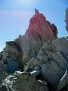
At the saddle (elevation ±10,550 feet) the summit of Bighorn Peak lies 0.25 miles to the east, with an elevation gain of ±325 feet. The route to the summit as seen from the saddle is shown in this photo.
Begin the scrambling along the ridge staying near the ridge crest, but eventually it will be necessary to drop off the north side of the ridge for a period, to avoid several pinnacles blocking progress along the ridge.
Coutour high along the north face near the ridge crest, and look for a gap which will regain the ridge beyond the pinnacles. There are several possible locations where this can be accomplished.
After regaining the ridge continue scrambling east towards the summit. There will at times be considerable exposure on the right (south) side of the ridge, and several spots requiring careful footwork.
Eventually the ridge levels with a final few hundred feet of easy boulder hopping to the summit.
Options for descent include retracing the route back to the summit of Lone Peak, or following the east ridge down to a saddle, with a descent down into Bells Canyon. The latter option would require a car shuttle.