
|
|
Route |
|---|---|
|
|
38.62560°N / 106.2505°W |
|
|
Hiking, Mountaineering, Scrambling, Skiing |
|
|
Spring, Summer, Fall, Winter |
|
|
Class 2 |
|
|
Overview
When the road is open (see the “Red Tape” section on the main page), this is currently the standard route to Tabeguache Peak. It is a bit longer than the old standard route (which is now closed) up Tabeguache and starts at the same trailhead. This route described below is open, but do not use the closed route up the southwest ridge.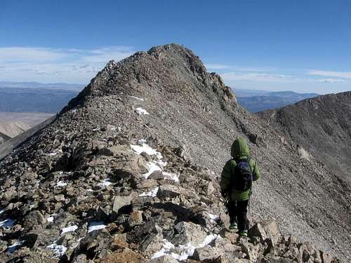 Approaching the summit of Tabeguache Peak from the West Ridge.
Getting There
From the intersection of US 285/US 50 in Poncha Springs, drive west on US 50 for ~6 miles and turn right (north) on County Road 240. After ~3 miles the pavement ends. The Angel of Shavano Campground is 0.6 miles farther.The road gets rougher after the campground and may require 4wd (though we made it fine in our Subaru). The trailhead is 3.8 miles beyond the Angel of Shavano Campground. Note that the forest service closes this road periodically due to logging operations and for other reasons.
Before heading out, make sure to check the Alters and Notices from the National Forest for road closures.
 Click for full size.
Route Description
From the trailhead, follow the good trail north through the forest. At 11,200 feet is a pond. Do not take the old closed trail here, but continue up the valley along Jennings Creek. There is a fairly good trail in some places, while in other places, it fades away. As time passes, the trail will likely get more well worn as more people use this route.For the most part, the route stays on the east side of the creek and there are several minor obstacles such as boulders to skirt. There are some bristlecone pines (the oldest trees in the world) in a few places in the valley.
Near the head of the valley, the route steepens. The route you want ascends to the obvious saddle at the head of the valley. Early season and with snow there are more variations possible and you can make a more direct line to the West Ridge.
 Upper Jennings Creek Basin. The route to the West Ridge climbs to the obvious saddle and then climbs east (right) to the summit of Tabeguache Peak.
Climb to the saddle (12,610 feet) which is between Carbonate Mountain and Tabeguache Peak. The route then turns east and follows the West Ridge of Tabeguache Peak to the summit. Along the way you will pass over the false summit of Point 13,936. The ridge is a little rough and slow in places, and has tedious scree, but the route to the summit of Tabeguache is obvious.
 High on the West Ridge of Tabeguache Peak.
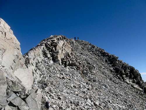 The summit of Tabeguache Peak from the West Ridge.
The round trip distance to the summit and back is 7.2 miles with 3900 feet elevation gain. After enjoying the summit, either return the same way, or climb east and over Mount Shavano before descending the Blank Gulch Route. Do not descend the Southwest Ridge of Tabeguache Peak.