
-
 3842 Hits
-
 71.06% Score
-
 1 Votes
|
|
Route |
|---|---|
|
|
37.99100°N / 106.894°W |
|
|
Hike/Scramble |
|
|
Half a day |
|
|
Class 3 |
|
|
Approach
The Stewart Creek Trailhead, Eddiesville Trailhead, and West Willow Creek Trailhead allow access to the West Ridge Route and are described on the main Organ Mountain page. The starting point of the route is the 13,100' saddle between San Luis and Organ. The Stewart Creek Trail leads directly to this point. The other trails put you on the Colorado Trail. From the West Willow Creek Trailhead you hike north until intersecting the Colorado Trail, which you follow east over two more saddles. From here you can take the South Ridge of San Luis to its summit and descend the trail coming from the opposite side to the saddle. You can accomplish the same from the Eddiesville Trailhead by following the Colorado Trail to the start of the South Ridge of San Luis. You could also take a cross country route from the Cochetopa Creek Valley directly to the saddle.
Route Description
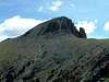
The 13,100' saddle between San Luis and Organ Mountain is broad and grassy. From this point head directly towards Organ Mountain leaving the Stewart Creek Trail and passing by a large stone cairn/tower. A large rock mound with cliffs to the south prevent following the ridge directly so bypass it to the north until you can gain the grassy ridge again. From here head up and over Point 13,477 along the ridge which gradually turns narrow and rocky.
From the top of the point you can see Organ Mountain and the location of a large discontinuity in the ridge. This notch is the crux of the climb and if you want to see it first hand you can continue along the ridge to the very edge. Otherwise you can begin a descending traverse along the south side of the ridge after coming down a bit off Point 13,477. Aim for a point somewhat below a large cave visible from the west which is approximately 200 vertical feet below the ridge. The traverse is mostly loose dirt and rocks. Upon reaching the edge of the gully that comes down the south side from the notch a straightforward downclimb into the gully should be obvious. The gully is pretty loose so I don't recommend hanging around in it for long. After crossing the gully you'll have to continue down it for a short ways to find a reasonable climb out.
From here begin to ascend to the ridge along the easiest route. An ascending traverse will put you back on the ridge where it is rounded and grassy again. The awesome columns of the south face wil be ahead as well as the remaining portion of the route which climbs up an obvious gap in the rock towers on the northwest face. Follow the ridge to the base of this gap and climb over boulders up to the columns. The sides of the gap are quite solid and provide the quickest means up. If you stay to the right side you can follow a pretty solid ridge to the summit once you are above the gap. Immediately to your right as you ascend this way the South Face drops away amongst the columns that give the mountain its name. There's a large cairn at the summit as well as a summit register.
 |  |  |
Essential Gear
I would suggest bringing a helmet along as there is some rock fall potential crossing the gap.
Miscellaneous Info
If you have information about this route that doesn't pertain to any of the other sections, please add it here.