
|
|
Route |
|---|---|
|
|
39.15220°N / 107.0608°W |
|
|
Mountaineering |
|
|
Summer |
|
|
One to two days |
|
|
class 4 |
|
|
West Ridge on Clark Peak
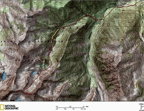
The above Topo is better viewed in Large format.
14 miles Round Trip and 5,540-vertical gain.
First, I wouldn’t recommend Clark Peak unless you are in excellent physical shape, feel comfortable off trail, feel comfortable navigating dense tree cover, feel comfortable climbing loose rock, feel comfortable on a skinny, highly exposed ridge. This is a 14 mile, 5,500-ft climb that will likely take you an entire day. If you feel comfortable with the above mentioned criteria then the West Ridge on Clark Peak has potential to be one of your all time favorite climbs.
Please read the Clark Peak Overview where I share some thoughts concerning the difficult approach to Moon Lake Basin. Also, crossing Snowmass Creek can be quite an adventure in spring. The April-June run-off is nothing to mess around with so plan accordingly.
Begin the approach from the Snowmass Creek Trailhead (8,400-ft.) This is a very busy TH. Arrive early on weekends for parking. Hike 1.5 mile on the Snowmass Creek trail and look sharp to the north, across a nice meadow loaded with cows for the West Snowmass Creek Drainage. Refer to Topo map. Leave the Snowmass Creek Trail, and hike down to Snowmass Creek. From here, locate a place to cross the swift creek. Pick up a nice single track trail that crosses the meadow and say hello to the cows for me.
Officially leave the private property (unlatch a fence) and follow a nice trail as it ascends up into West Snowmass Creek Drainage. Around 9,870-ft or 3.2 miles into the hike you will come to an obvious large meadow. This is where things get confusing. At the meadow, the trail will split. As I recall, one trail begins to descend south to the creek. This trail is fairly easy to follow, however it is the wrong trail. Instead, continue going straight where the trail splits. Stay high on the north side of the meadow, following game trails. Soon, the meadow will give way to a wooded draw. Look for a faint, ascending trail that begins a traverse of the southeast slopes of Haystack Mountain (marked in yellow on topo.) If you do not locate this trail stay low and bushwhack up the dense wooded draw. The trail ascends a steep slope to another meadow east of Mount Daly. The trail is obvious here. Soon the meadow will end, and at this point, cross to the east side of the creek. From here, ascend a good trail up another steep slope. Just east of Moon Lake, the trail will fade away, mostly due to the beginning of a massive boulder field. Make your way into the rugged basin directly south of Moon Lake.
Once up into the rugged basin, locate the low point of Clark’s west ridge and begin a death march up the boulder laden slope. Most of the rock up this slope is somewhat solid. The slope will steepen toward the ridge crest and class 3 scrambling is required.
Gain the ridge crest and observe the west ridge Clark Peak. I won’t describe the ridge route in detail because I don’t want to spoil your sense of adventure. However I will say the ridge is long, distance and time-wise, and goes with constant class 3 and class 4 scrambling. The ridge will appear to be narrow, very exposed and loose. The drop-offs are considerable to the north and south. Do not attempt this ridge run in bad weather. The ridge route is extremely exposed to the elements with no escape.