Western States Highpointing
Since I had already climbed seven of the western state highpoints: CA, MT, NV, AZ, OR, WA and ID, I decided I would like to climb some of the remaining ones. On July 9, 2004, I hit the road to bag additional western state highpoints. My plan was to mix some driving with climbing…the driving turned out to be the hardest part, although it was quite amazing to see the wide variety of scenery we are blessed with in the west. Of course there were beautiful mountains and rivers, but also the rolling plains with lush green grasses and huge cattle herds were seemingly endless.
The raw statistics were:
Days - 6
Miles driven – 3,774
Miles hiked – 59
Highpoints visited – 8
Elevation gained – 16,275’
Some brief notes about the trip:
1. Failed to properly condition gluteus maximus prior to start!!!
2. Peak reports:
a. Wheeler Peak, NM (13,161’) – Located in the Wheeler Peak
![Wheeler Peak, NM]() Wheeler Peak
Wheeler PeakWilderness Area of Carson National Forest just outside the Taos Ski Valley resort in beautiful country. The hike is very pleasant up to Williams Lake which lies beneath the mountain. From the lake, you ascend a steep, somewhat loose slope (unpleasant) to a saddle north of the peak and follow the ridge to the top. The roundtrip is about 6.2 miles with about 3,250’ elev. gain. Clouds were rolling in as I climbed on 7/10/04 following a start of 5:35 am (All times are Las Vegas time!). At the summit, there is a great register constructed from approx. 5” diameter iron pipe with a threaded cap, but my hands were so cold due to the cool, windy conditions that I had to hold the pen with both hands to laboriously write my name. I quickly retreated back down to where the weather was mild and sunny and finished the hike at 8:40 am. The drive from Las Vegas was 741 miles and took me 13 ½ hours.
b. Black Mesa, OK (4,973’) – Located in the Black Mesa Nature
![Black Mesa, OK]() Black Mesa, OK
Black Mesa, OKPreserve about 5 ½ miles from Kenton, OK, this hike is quite nice through cattle country up a well marked trail to the top of the mesa. Black Mesa is one of the largest mesas in the world, extending over 40 miles into New Mexico and Colorado. It is a basalt-capped plateau formed by the flow of an ancient volcano. This highpoint is 1,299’ east of New Mexico, 53 miles WSW of Kansas, 31 miles north of Texas, and 7 miles south of Colorado. The roundtrip hike is about 8.6 miles with about 775’ elev. gain. The weather was about 82 and sunny as I started at 2:05 pm on 7/10/04. The hike took 2 ½ hours. The drive from Wheeler Peak was about 245 miles and took me 5 hours.
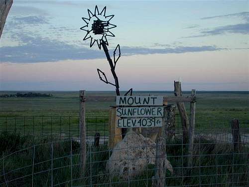
c. Mt Sunflower, KS (4,039’) – Located in a pasture filled with Black Angus cattle, this hike is ¼ mile unless you choose to drive to the
![Mount Sunflower, KS]() Mt Sunflower, KS
Mt Sunflower, KS summit! It was 60 degrees as I made a mountaineering start of my climb at 4:30 am on 7/11/04. Mt Sunflower is named for the Kansas state flower. At the high point there is a 6’ high sunflower made from railroad spikes and a large boulder. The drive from Black Mesa was 280 miles and took me about 5 ½ hours.
d. Panorama Pt, NE ( 5,424’) – Located in a pasture about 17 miles southeast of Pine Bluffs, WY, this is another highpoint that can be
![Panorama Pt, NE]() Panorama Pt, NE
Panorama Pt, NE reached in your vehicle. The drive was about 304 miles from Mt Sunflower and took me about 6 hours.
e. Harney Peak, SD (7,242’) – Located in the Black Elk Wilderness area of the Black Hills National Forest about 7 miles NE of Custer, SD, this hike started at the Sylvan lake recreational area. It was a very scenic and pleasant hike of about 5.8 miles gaining some 1,600’ in
![Harney Peak, SD]() Mt Harney, SD
Mt Harney, SD elevation to a fire lookout tower built by the CCC in 1938-39 and manned until 1967. This highpoint is the highest point east of the Rockies and west of the Pyrenees mountains of Western Europe. The hike took me 2 ¼ hours on 7/11/04 since I started late in the day and didn’t want to be on the trail after sunset. This was the third highpoint I visited on that day. The drive from Panorama Pt was about 272 miles and took me about 5 hours.
f. White Butte, ND (3,506’) – Located on a ranch about 8 miles SE of Amidon, ND, this highpoint is on private property. I met the owner and his young son who drove up in their pickup shortly after I arrived by the old ranchhouse. They easily granted permission to visit the highpoint and mentioned that they were asking climbers to contribute $20 for the
![White Butte, ND]() White Butte, ND
White Butte, ND privilege. The hike is about 2 miles roundtrip and gains about 400’ elevation passing through some rattlesnake infested ranchland. I started my climb at 6:15 am on 7/12/04 and it took me about 45 minutes. The register shows that it is a popular destination with people visiting most days during the summer. The drive from Harney Peak was about 231 miles and took me about 5 hours.
g. Mount Elbert, CO (14,433’) – Located in the San Isabel National Forest about 25 miles from Leadville, CO. I climbed the Black Cloud trail which gains about 5,300’ and passes over South Mt Elbert ( 14,134’) on the way to the peak. The climb is about 11 miles roundtrip and gets your
![Mount Elbert, CO]() Mt Elbert, CO
Mt Elbert, CO attention very early on due to the steepness and elevation. It parallels the Black Cloud creek as it ascends through beautiful alpine terrain. There were two Class 4? creek crossings over narrow and precarious logs. The views from the peaks are magnificent. I started the climb at 5 am on 7/13/04 having set up my tent at the trailhead the previous night upon arrival just before dark. The ascent took 3 ½ hours while the descent only required 2 hours. The drive from White Butte was about 692 miles and took me 12 ½ hours.
h. Kings Peak, UT ( 13,528’) – Located in the High Uintas Wilderness Area of the Ashley and Wasatch National Forests about 39 miles South of Mountain View, WY, one of the challenges was the gravel roads which extend about 32 miles to the Henrys Fork Campground trailhead. Some sections were in good shape due to recent grading and rainfall the day I was in the vicinity (no dust).
![Kings Peak, UT]() Kings Peak, UT
Kings Peak, UT Other sections were bone jarring, even at 10 mph, with deep, water-filled potholes. I approached from the south and took a shortcut? from Lonetree, WY which bumps over about 15 miles of rocky road. Unfortunately, it has not been graded in years and was full of large rocks and potholes. I considered turning back after about 3 miles and again at about 6 miles, but by then the prospects of backing off seemed worse than proceeding. It was probably beautiful country, but by then it was nearly dark and I was hunting and pecking looking for the trailhead…my advice – approach from the north from Mountain View, WY. Forget about Lonetree, WY which had only one sign which faced traffic coming south so I had to turn around to figure out I was in beautiful, downtown Lonetree which had one or two residences. If you have time, there is a magnificent stretch of highway between Vernal, UT and Mountain View, WY which skirts Flaming Gorge Reservoir.
This climb was the highlight of my trip! I started at 5 am and the trail to Gunsight Pass was delightful, traveling south along Henry’s Fork creek for about 6 or 7 miles slowly gaining elevation as it travels up the valley. Once you get to Gunsight Pass which is about 9.6 miles in, the route crosses the pass and drops into the next valley where it intersects with a trail heading for Anderson Pass which is South of Gunsight. Rather than descend and have to regain elevation on trails, you can start a gradually ascending traverse at Gunsight at about the 11,900’ level around the SE flank of peak 13,103’ and save a couple of trail miles. There were no difficulties encountered and this efficiently placed me near Anderson pass from which area you start a ridge climb SSE up to the summit. The weather in High Uintas Wilderness is frequently dicey and on 7/14/04, shortly after I reached the summit at 10:05 am, it started to spit sleet/hail. I hastily retreated down the mountain as thunder was beginning and by the time I was back to Gunsight Pass, it had started raining and there was serious thunder and lightning on all points of the compass. The rain was only light and lasted a couple of hours, but the continuous sounds of thunder echoing through the valley were really impressive. I negotiated several swampy sections along the trail which threatened to overwhelm the tops of my boots and arrived back at the trailhead by 2:30 pm with mud up to the knees of my pants! The climb is listed as 28.8 miles with 5,350’ elev. gain, but I probably cut off at least 1,500’ of vertical and 2 or 3 miles by use of the traverse from Gunsight Pass. The drive from Mt Elbert was about 427 miles and took me 9 ½ hours. Since it was early in the afternoon, I decided to drive home and that drive is about 582 miles and took me 10 ¼ hours ending my odyssey at 1 am on 7/15/04.
3. Interesting towns along the route:
Albuquerque, NM; Santa Fe, NM; Taos, NM; Custer, SD; Deadwood, SD; Cheyenne, WY; Denver, CO; Leadville, CO; Aspen, CO; and Salt Lake City, UT


Comments
Post a Comment